- Electric and Telecom Plans Free
- Fire and Emergency Plans Free
- Floor Plans Free
- Plant Layout Plans Free
- School and Training Plans Free
- Seating Plans Free
- Security and Access Plans Free
- Site Plans Free
- Sport Field Plans Free
- Business Process Diagrams Free
- Business Process Mapping Free
- Classic Business Process Modeling Free
- Cross-Functional Flowcharts Free
- Event-driven Process Chain Diagrams Free
- IDEF Business Process Diagrams Free
- Logistics Flow Charts Free
- Workflow Diagrams Free
- ConceptDraw Dashboard for Facebook Free
- Mind Map Exchange Free
- MindTweet Free
- Note Exchange Free
- Project Exchange Free
- Social Media Response Free
- Active Directory Diagrams Free
- AWS Architecture Diagrams Free
- Azure Architecture Free
- Cisco Network Diagrams Free
- Cisco Networking Free
- Cloud Computing Diagrams Free
- Computer Network Diagrams Free
- Google Cloud Platform Free
- Interactive Voice Response Diagrams Free
- Network Layout Floor Plans Free
- Network Security Diagrams Free
- Rack Diagrams Free
- Telecommunication Network Diagrams Free
- Vehicular Networking Free
- Wireless Networks Free
- Comparison Dashboard Free
- Composition Dashboard Free
- Correlation Dashboard Free
- Frequency Distribution Dashboard Free
- Meter Dashboard Free
- Spatial Dashboard Free
- Status Dashboard Free
- Time Series Dashboard Free
- Basic Circle-Spoke Diagrams Free
- Basic Circular Arrows Diagrams Free
- Basic Venn Diagrams Free
- Block Diagrams Free
- Concept Maps Free
- Family Tree Free
- Flowcharts Free
- Basic Area Charts Free
- Basic Bar Graphs Free
- Basic Divided Bar Diagrams Free
- Basic Histograms Free
- Basic Line Graphs Free
- Basic Picture Graphs Free
- Basic Pie Charts Free
- Basic Scatter Diagrams Free
- Aerospace and Transport Free
- Artwork Free
- Audio, Video, Media Free
- Business and Finance Free
- Computers and Communications Free
- Holiday Free
- Manufacturing and Maintenance Free
- Nature Free
- People Free
- Presentation Clipart Free
- Safety and Security Free
- Analog Electronics Free
- Audio and Video Connectors Free
- Basic Circuit Diagrams Free
- Chemical and Process Engineering Free
- Digital Electronics Free
- Electrical Engineering Free
- Electron Tube Circuits Free
- Electronic Block Diagrams Free
- Fault Tree Analysis Diagrams Free
- GHS Hazard Pictograms Free
- Home Automation and Wiring Free
- Mechanical Engineering Free
- One-line Diagrams Free
- Power Сircuits Free
- Specification and Description Language (SDL) Free
- Telecom and AV Circuits Free
- Transport Hazard Pictograms Free
- Data-driven Infographics Free
- Pictorial Infographics Free
- Spatial Infographics Free
- Typography Infographics Free
- Calendars Free
- Decision Making Free
- Enterprise Architecture Diagrams Free
- Fishbone Diagrams Free
- Organizational Charts Free
- Plan-Do-Check-Act (PDCA) Free
- Seven Management and Planning Tools Free
- SWOT and TOWS Matrix Diagrams Free
- Timeline Diagrams Free
- Australia Map Free
- Continent Maps Free
- Directional Maps Free
- Germany Map Free
- Metro Map Free
- UK Map Free
- USA Maps Free
- Customer Journey Mapping Free
- Marketing Diagrams Free
- Matrices Free
- Pyramid Diagrams Free
- Sales Dashboard Free
- Sales Flowcharts Free
- Target and Circular Diagrams Free
- Cash Flow Reports Free
- Current Activities Reports Free
- Custom Excel Report Free
- Knowledge Reports Free
- MINDMAP Reports Free
- Overview Reports Free
- PM Agile Free
- PM Dashboards Free
- PM Docs Free
- PM Easy Free
- PM Meetings Free
- PM Planning Free
- PM Presentations Free
- PM Response Free
- Resource Usage Reports Free
- Visual Reports Free
- House of Quality Free
- Quality Mind Map Free
- Total Quality Management TQM Diagrams Free
- Value Stream Mapping Free
- Astronomy Free
- Biology Free
- Chemistry Free
- Language Learning Free
- Mathematics Free
- Physics Free
- Piano Sheet Music Free
- Android User Interface Free
- Class Hierarchy Tree Free
- Data Flow Diagrams (DFD) Free
- DOM Tree Free
- Entity-Relationship Diagram (ERD) Free
- EXPRESS-G data Modeling Diagram Free
- IDEF0 Diagrams Free
- iPhone User Interface Free
- Jackson Structured Programming (JSP) Diagrams Free
- macOS User Interface Free
- Object-Role Modeling (ORM) Diagrams Free
- Rapid UML Free
- SYSML Free
- Website Wireframe Free
- Windows 10 User Interface Free
Metro Map
Mass rapid transit is also known to be called as a heavy rail, a metro, a subway, a tube, or an underground. It is a type of a high-capacity public transport usually found in most of the urban areas all over the world. Unlike trams or buses, such rapid transit systems are electric railways. They operate on an exclusive right-of-way. They cannot be accessed by pedestrians or other vehicles, often being grade separated either on elevated railways or in tunnels.
Modern services on rapid transit systems may be provided on the designated lines between stations. They usually use the electric multiple rail tracks. Sometimes some of such systems use guided rubber tires, monorail or magnetic levitation. The stations usually have high platforms, having no steps inside the trains. They require the custom-made trains for minimizing the gaps between a platform and a train.
Being integrated with other public transport, they are operated by the same public transport authorities. Nevertheless, some of the rapid transit systems have the so-called “at-grade intersections” between a rapid transit line and a road. Sometimes they have such intersections between two rapid transit lines, being unchallenged in its ability to transport too many people quickly over some short distances.
Metro is known to be the most common term for underground rapid transit systems. It is usually used by the non-native English speakers. It is always possible to create the needed metro map by using the ConceptDraw DIAGRAM diagramming and drawing software either from a scratch or by editing the already created drawings by using the Metro Map solution.
The Metro Map solution enables to create the needed metro maps, bus and other transport maps and transport schemes, as well as the tube-style infographics and route maps, allowing one to control the direction in which any ConceptDraw DIAGRAM user can create new stations, add text icons/labels and change the lengths of the pre-made drawings as the solution contains such design objects as the representations of the Lines, the Landmarks, and the Stations.
The Metro Map solution includes the Replicating Objects as well as the Switching Objects, enabling the transport managers, metro stations builders as well as transport project managers to end up having a professionally looking vector graphic document.
-
Install this solution Free -
What I need to get started -
Solution Requirements - This solution requires the following products to be installed:
ConceptDraw DIAGRAM v18 - This solution requires the following products to be installed:
-
Compatibility - Sonoma (14), Sonoma (15)
MS Windows 10, 11 - Sonoma (14), Sonoma (15)
-
Support for this Solution -
Helpdesk
Design Elements — Metro Maps

Related News:
Examples
There are a few samples that you see on this page which were created in the ConceptDraw DIAGRAM application by using the Metro Map solution. Some of the solution's capabilities as well as the professional results which you can achieve are all demonstrated here on this page.
All source documents are vector graphic documents which are always available for modifying, reviewing and/or converting to many different formats, such as MS PowerPoint, PDF file, MS Visio, and many other graphic ones from the ConceptDraw Solution Park or ConceptDraw STORE. The Metro Map solution is available to all ConceptDraw DIAGRAM users to get installed and used while working in the ConceptDraw DIAGRAM diagramming and drawing software.
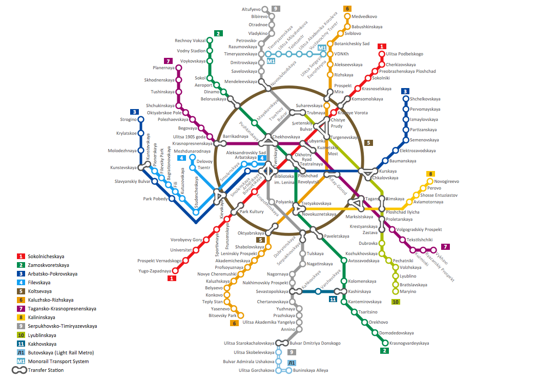
Example 1: Metro Map — London Tube
This diagram was created in ConceptDraw DIAGRAM using the Transport Map Library from the Metro Map Solution. An experienced user spent 40 minutes creating this sample.
This sample shows the London Tube opened in 1863. Explore the oldest public metro system in the world with this subway map created with ConceptDraw DIAGRAM. Each subway line has its own color and line width on the subway map to maximize visibility.

Example 2: Metro Map — Los Angeles Metro Rail and Liner
This diagram was created in ConceptDraw DIAGRAM using the Transport Map Library from the Metro Map Solution. An experienced user spent 20 minutes creating this sample.
This sample shows a map of the Los Angeles Metro Rail, a rapid-transit rail system consisting of six separate lines serving 80 stations. A legend is a useful way to explain the notation to any viewers of the subway map.

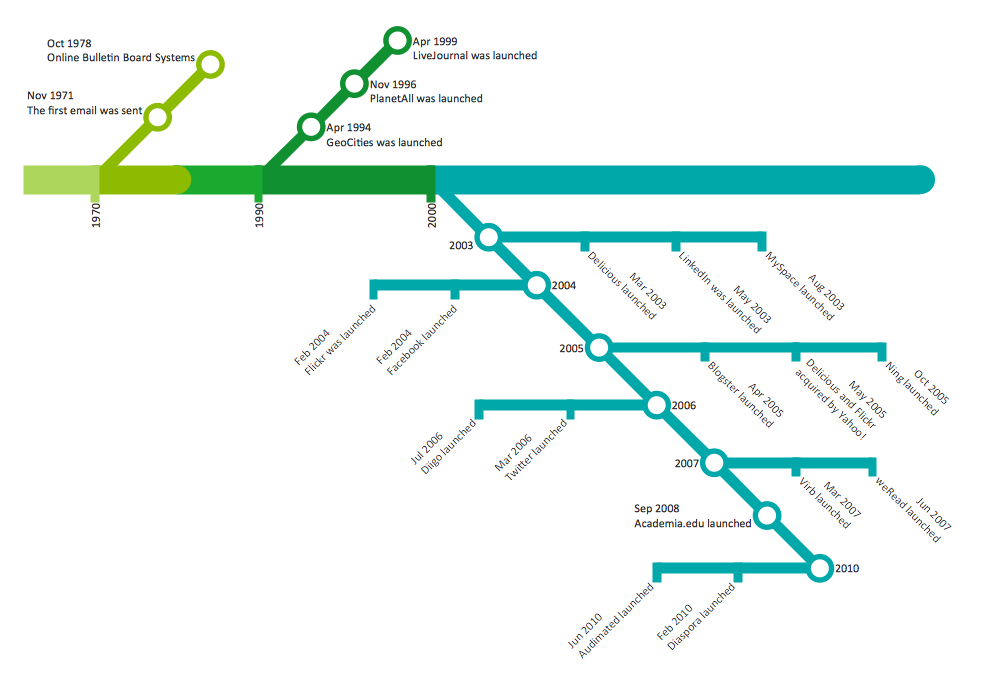
Example 3: Metro Map — E-mail History
This diagram was created in ConceptDraw DIAGRAM using the Transport Map Library from the Metro Map Solution. An experienced user spent 10 minutes creating this sample.
This sample visualizes the history of E-mail in an interesting and specific view that is both understandable and convenient. Use bright colors to make metro maps more attractive.

Example 4: Metro Map — ARL Route Map
This diagram was created in ConceptDraw DIAGRAM using the Transport Map Library from the Metro Map Solution. An experienced user spent 5 minutes creating this sample.
This sample shows an ARL route map. Designing maps in ConceptDraw DIAGRAM, you can easily apply different styles to the routes for a different appearance, if necessary. Various vector objects can be used to signify additional information; for example, you can show location of parts of the world relative to your route and metro maps of local transit systems.

Example 5: Subway Map — Tokyo Tube Map
This diagram was created in ConceptDraw DIAGRAM using the Transport Map Library from the Metro Map Solution. An experienced user spent 35 minutes creating this sample.
This sample illustrates the most extensive mass transit system in the world — Tokyo Tube Map. Look at this subway map – it has an extremely complex structure. Use the predesigned vector objects from the ConceptDraw DIAGRAM libraries to design similarly complex routes and metro maps, metro path maps, subway train maps, and metro train maps in mere minutes.

Example 6: MTA Subway Map — New York City Subway
This diagram was created in ConceptDraw DIAGRAM using the Transport Map Library from the Metro Map Solution. An experienced user spent 40 minutes creating this sample.
This sample shows the MTA Subway Map in New York City. The Metropolitan Transportation Authority (MTA) is a largest public benefit corporation which is responsible for public transportation in12 counties in southeastern New York and 2 counties in southwestern Connecticut.
More Examples and Templates

Inside


What I Need to Get Started
Both ConceptDraw DIAGRAM diagramming and drawing software and the Metro Map solution can help creating the illustrations you need. The Metro Map solution can be found in the Maps area of ConceptDraw STORE application that can be downloaded from this site. Make sure that both ConceptDraw DIAGRAM and ConceptDraw STORE applications are installed on your computer before you get started.
How to install
After ConceptDraw STORE and ConceptDraw DIAGRAM are downloaded and installed, you can install the Metro Map solution from the ConceptDraw STORE.

Start Using
To make sure that you are doing it all right, use the pre-designed symbols from the stencil libraries from the solution to make your drawings look smart and professional. Also, the pre-made examples from this solution can be used as drafts so your own drawings can be based on them. Using the samples, you can always change their structures, colors and data.
