- Electric and Telecom Plans Free
- Fire and Emergency Plans Free
- Floor Plans Free
- Plant Layout Plans Free
- School and Training Plans Free
- Seating Plans Free
- Security and Access Plans Free
- Site Plans Free
- Sport Field Plans Free
- Business Process Diagrams Free
- Business Process Mapping Free
- Classic Business Process Modeling Free
- Cross-Functional Flowcharts Free
- Event-driven Process Chain Diagrams Free
- IDEF Business Process Diagrams Free
- Logistics Flow Charts Free
- Workflow Diagrams Free
- ConceptDraw Dashboard for Facebook Free
- Mind Map Exchange Free
- MindTweet Free
- Note Exchange Free
- Project Exchange Free
- Social Media Response Free
- Active Directory Diagrams Free
- AWS Architecture Diagrams Free
- Azure Architecture Free
- Cisco Network Diagrams Free
- Cisco Networking Free
- Cloud Computing Diagrams Free
- Computer Network Diagrams Free
- Google Cloud Platform Free
- Interactive Voice Response Diagrams Free
- Network Layout Floor Plans Free
- Network Security Diagrams Free
- Rack Diagrams Free
- Telecommunication Network Diagrams Free
- Vehicular Networking Free
- Wireless Networks Free
- Comparison Dashboard Free
- Composition Dashboard Free
- Correlation Dashboard Free
- Frequency Distribution Dashboard Free
- Meter Dashboard Free
- Spatial Dashboard Free
- Status Dashboard Free
- Time Series Dashboard Free
- Basic Circle-Spoke Diagrams Free
- Basic Circular Arrows Diagrams Free
- Basic Venn Diagrams Free
- Block Diagrams Free
- Concept Maps Free
- Family Tree Free
- Flowcharts Free
- Basic Area Charts Free
- Basic Bar Graphs Free
- Basic Divided Bar Diagrams Free
- Basic Histograms Free
- Basic Line Graphs Free
- Basic Picture Graphs Free
- Basic Pie Charts Free
- Basic Scatter Diagrams Free
- Aerospace and Transport Free
- Artwork Free
- Audio, Video, Media Free
- Business and Finance Free
- Computers and Communications Free
- Holiday Free
- Manufacturing and Maintenance Free
- Nature Free
- People Free
- Presentation Clipart Free
- Safety and Security Free
- Analog Electronics Free
- Audio and Video Connectors Free
- Basic Circuit Diagrams Free
- Chemical and Process Engineering Free
- Digital Electronics Free
- Electrical Engineering Free
- Electron Tube Circuits Free
- Electronic Block Diagrams Free
- Fault Tree Analysis Diagrams Free
- GHS Hazard Pictograms Free
- Home Automation and Wiring Free
- Mechanical Engineering Free
- One-line Diagrams Free
- Power Сircuits Free
- Specification and Description Language (SDL) Free
- Telecom and AV Circuits Free
- Transport Hazard Pictograms Free
- Data-driven Infographics Free
- Pictorial Infographics Free
- Spatial Infographics Free
- Typography Infographics Free
- Calendars Free
- Decision Making Free
- Enterprise Architecture Diagrams Free
- Fishbone Diagrams Free
- Organizational Charts Free
- Plan-Do-Check-Act (PDCA) Free
- Seven Management and Planning Tools Free
- SWOT and TOWS Matrix Diagrams Free
- Timeline Diagrams Free
- Australia Map Free
- Continent Maps Free
- Directional Maps Free
- Germany Map Free
- Metro Map Free
- UK Map Free
- USA Maps Free
- Customer Journey Mapping Free
- Marketing Diagrams Free
- Matrices Free
- Pyramid Diagrams Free
- Sales Dashboard Free
- Sales Flowcharts Free
- Target and Circular Diagrams Free
- Cash Flow Reports Free
- Current Activities Reports Free
- Custom Excel Report Free
- Knowledge Reports Free
- MINDMAP Reports Free
- Overview Reports Free
- PM Agile Free
- PM Dashboards Free
- PM Docs Free
- PM Easy Free
- PM Meetings Free
- PM Planning Free
- PM Presentations Free
- PM Response Free
- Resource Usage Reports Free
- Visual Reports Free
- House of Quality Free
- Quality Mind Map Free
- Total Quality Management TQM Diagrams Free
- Value Stream Mapping Free
- Astronomy Free
- Biology Free
- Chemistry Free
- Language Learning Free
- Mathematics Free
- Physics Free
- Piano Sheet Music Free
- Android User Interface Free
- Class Hierarchy Tree Free
- Data Flow Diagrams (DFD) Free
- DOM Tree Free
- Entity-Relationship Diagram (ERD) Free
- EXPRESS-G data Modeling Diagram Free
- IDEF0 Diagrams Free
- iPhone User Interface Free
- Jackson Structured Programming (JSP) Diagrams Free
- macOS User Interface Free
- Object-Role Modeling (ORM) Diagrams Free
- Rapid UML Free
- SYSML Free
- Website Wireframe Free
- Windows 10 User Interface Free
Germany Map
Germany is a federal parliamentary republic. It is situated in the central-western part of Europe and it includes 16 constituent states. Covering an area of 357021 square kilometres, Germany has a largely temperate seasonal climate. There are about 82 million people who live Germany on a constant basis which makes this country the most populous member state of the EU.
Germany is known to be the second most popular immigration destination in the world after the USA. Its capital, as well as the largest metropolis, is Berlin. At the same time, its largest conurbation is the Ruhr (its main centres are Essen and Dortmund). There is a long list of the other major cities of this country: Munich, Hamburg, Cologne, Stuttgart, Frankfurt, Dusseldorf, Bremen, Leipzig, Dresden, Nuremberg, and Hannover.
Germany is located in Central and Western Europe. Denmark is bordering it to the north, the Czech Republic, and Poland - to the east and Austria to the south-east. Switzerland is also Germany’s neighbour which can be found on the map to the south-southwest. Besides, there are France, Belgium, the Netherlands, and Luxembourg around.
Germany is also bordered by the North Sea as well as by the Baltic Sea. Covering the territory of 357021 square kilometres, Germany consists of 349223 square kilometres of land being known as the seventh largest country by area in Europe.
ConceptDraw DIAGRAM diagramming and drawing software makes it possible to create any needed map of Germany from a scratch but using the Germany Map solution may enable any ConceptDraw DIAGRAM user to design it quicker by providing the collection of the pre-made examples and templates of the maps as well as the vector stencil graphic maps of Germany, including all its 16 states.
The Germany Map solution can be used as the base for making various thematic maps that can reflect any needed information concerning Germany by all the ConceptDraw DIAGRAM users.
-
Install this solution Free -
What I need to get started -
Solution Requirements - This solution requires the following products to be installed:
ConceptDraw DIAGRAM v18 - This solution requires the following products to be installed:
-
Compatibility - Sonoma (14), Sonoma (15)
MS Windows 10, 11 - Sonoma (14), Sonoma (15)
-
Support for this Solution -
Helpdesk
There is 1 library containing 19 vector objects in the Germany Map solution.
Design Elements — Germany

Related News:
Examples
There are a few samples that you see on this page which were created in the ConceptDraw DIAGRAM application by using the Germany Map solution. Some of the solution's capabilities as well as the professional results which you can achieve are all demonstrated here on this page.
All source documents are vector graphic documents which are always available for modifying, reviewing and/or converting to many different formats, such as MS PowerPoint, PDF file, MS Visio, and many other graphic ones from the ConceptDraw Solution Park or ConceptDraw STORE. The Germany Map solution is available to all ConceptDraw DIAGRAM users to get installed and used while working in the ConceptDraw DIAGRAM diagramming and drawing software.
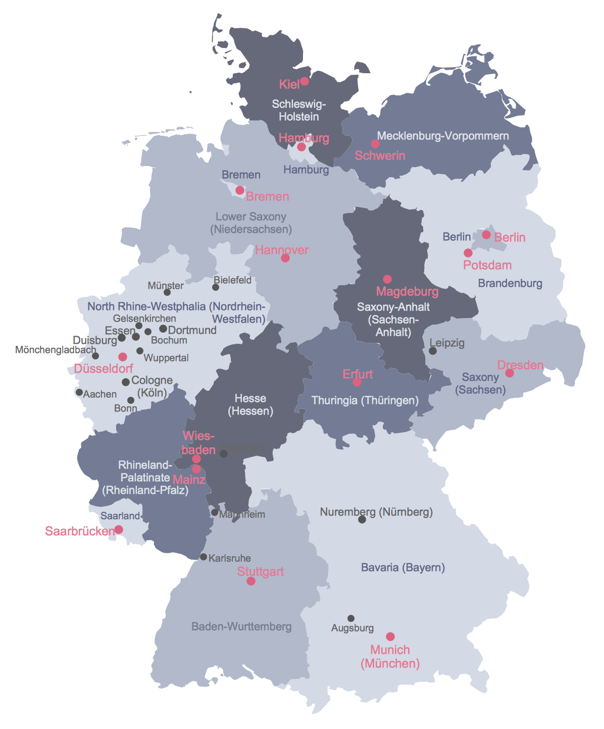
Example 1: Political Map of Germany
This diagram was created in ConceptDraw DIAGRAM using a Germany library from the Germany Map Solution. An experienced user spent 5 minutes creating this sample.
This sample shows detailed political map of Germany with cities. Varied coloring of each state allows visually detach them each from other on the map. The excellent idea to color brightly in red the names of major cities.
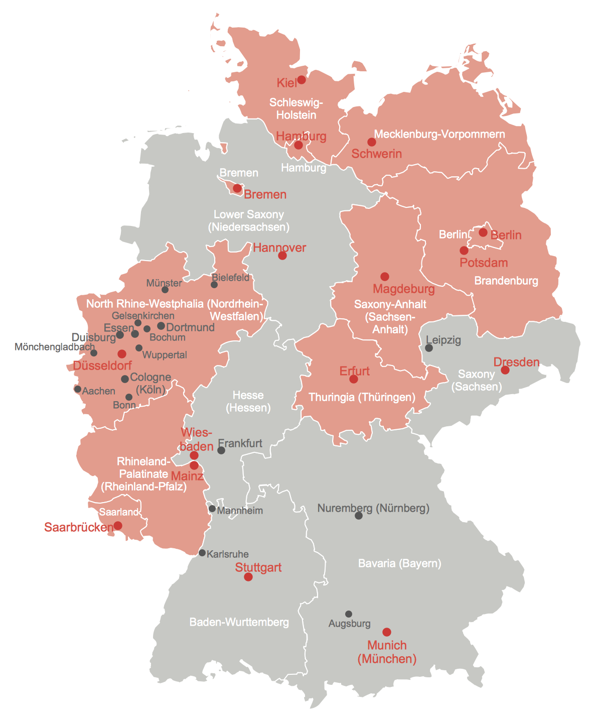
Example 2: States of Germany with Freedom of Information Legislation
This diagram was created in ConceptDraw DIAGRAM using a Germany library from the Germany Map Solution. An experienced user spent 5 minutes creating this sample.
Freedom of information legislation presumes for each person the unconditional right to access official federal information. This sample vector map illustrates the states of Germany, which have approved the Freedom of Information laws assumed in Germany.
Example 3: Map of Germany in Eurozone
This diagram was created in ConceptDraw DIAGRAM using a Germany library from the Germany Map Solution. An experienced user spent 5 minutes creating this sample.
The Germany Map solution helps quickly design various maps of Germany, including the detailed maps for each of Germany's states, and vice versa extensive maps depicting Germany as part of EU on the map of Europe.

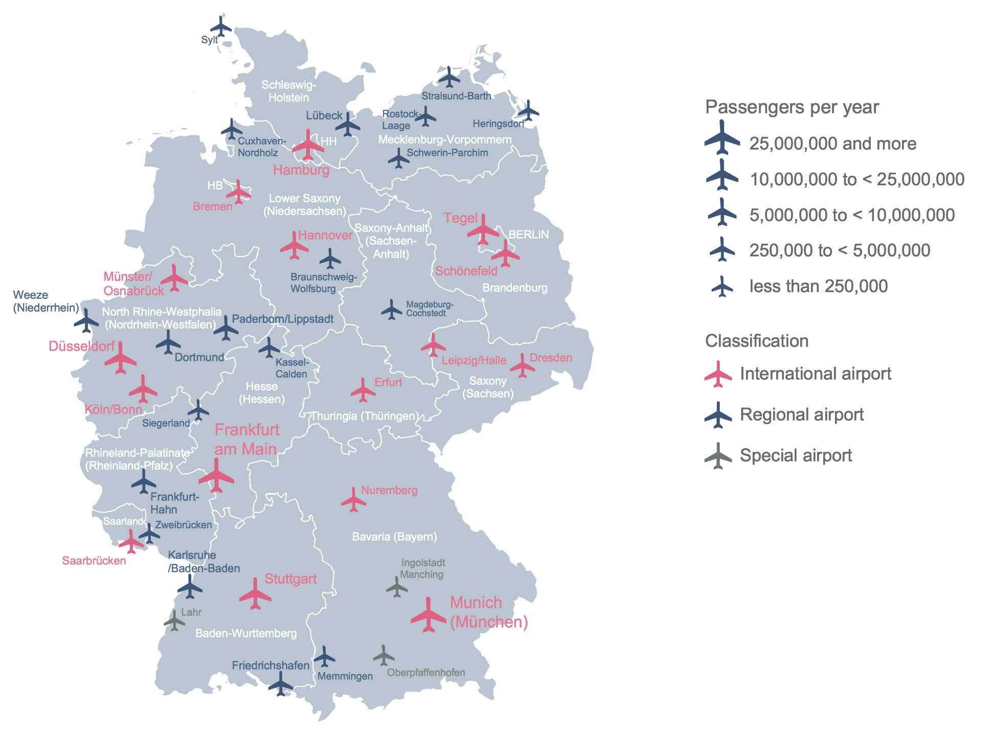
Example 4: Airports in Germany
This diagram was created in ConceptDraw DIAGRAM using a Germany library from the Germany Map Solution. An experienced user spent 5 minutes creating this sample.
Thematic map is a pictorial reflection and effective visual way to structure important information and data. This map of Germany depicts all airports situated in Germany and classifies them by quantity of passengers per year.
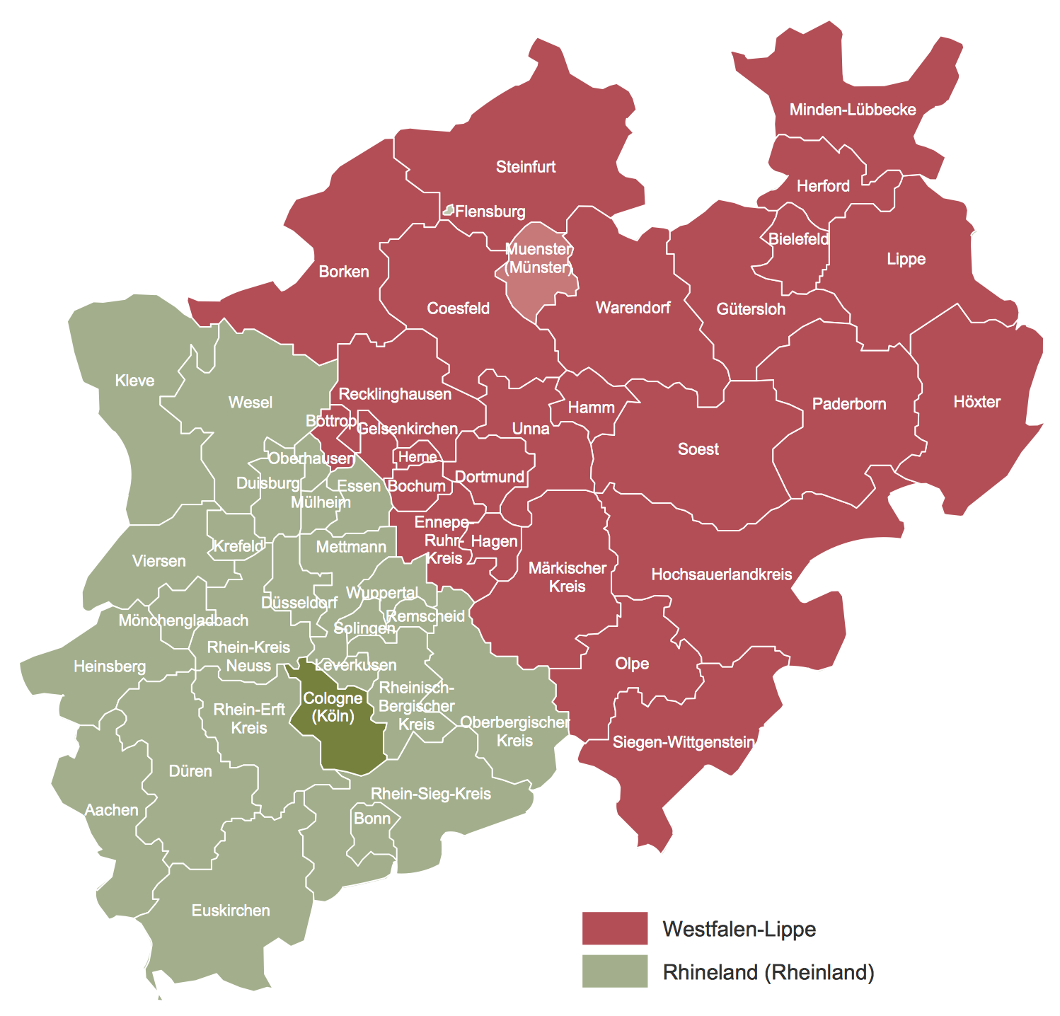
Example 5: Map of the Two Regional Authorities in North Rhine-Westphalia
This diagram was created in ConceptDraw DIAGRAM using a Germany library from the Germany Map Solution. An experienced user spent 5 minutes creating this sample.
This catchy map demonstrates the regional authorities Rhineland (green) and Westphalia-Lippe (red) in North Rhine-Westphalia, which is the most populous state of Germany. It was created in minutes on the base of ready map of North Rhine-Westphalia offered by Germany Map solution for ConceptDraw DIAGRAM
More Examples and Templates

Batrachotomus Germany Localisation Map

EU Countries Map — Renewable Electricity Generation

Germany Crop Areas Map — Sugar Beets

Map of German States

Map of Germany Districts

Federal States of Germany Map

Germany Districts Map

Germany Location Map

Locator Map of Baden-Wurttemberg

Locator Map of Bavaria

Locator Map of Berlin

Locator Map of Brandenburg

Locator Map of Bremen

Locator Map of Hamburg

Locator Map of Hesse

Locator Map of Lower Saxony

Locator Map of Mecklenburg-Vorpommern

Locator Map of North Rhine-Westphalia

Locator Map of Rhineland-Palatinate

Locator Map of Saarland

Locator Map of Saxony

Locator Map of Saxony-Anhalt

Locator Map of Schleswig-Holstein

Locator Map of Thuringia
Inside


What I Need to Get Started
Both ConceptDraw DIAGRAM diagramming and drawing software and the Germany Map solution can help creating the illustrations you need. The Germany Map solution can be found in the Maps area of ConceptDraw STORE application that can be downloaded from this site. Make sure that both ConceptDraw DIAGRAM and ConceptDraw STORE applications are installed on your computer before you get started.
How to install
After ConceptDraw STORE and ConceptDraw DIAGRAM are downloaded and installed, you can install the Germany Map solution from the ConceptDraw STORE.

Start Using
To make sure that you are doing it all right, use the pre-designed symbols from the stencil libraries from the solution to make your drawings look smart and professional. Also, the pre-made examples from this solution can be used as drafts so your own drawings can be based on them. Using the samples, you can always change their structures, colors and data.

Germany Maps
Germany is a federal republic made up of sixteen federal states. After notable periods of political upheaval over the last century, since the fall of the Berlin Wall and the re-unification of East and West Germany, the geographical borders of these states have remained stable and unchanged. For administrative purposes, these states are further divided into governmental districts, rural or urban districts, and municipalities.
Of the sixteen states, three are known as 'city states', covering the populous cities of Hamburg, Berlin and Bremen. The other thirteen are termed 'area states', and cover a larger geographic area. The full list is as follows:
- Baden-Württemberg
- Bavaria
- Berlin
- Brandenburg
- Bremen
- Hamburg
- Hesse
- Lower Saxony
- Mecklenburg-Western Pomerania
- North Rhine-Westphalia
- Rhineland-Palatinate
- Saarland
- Saxony
- Saxony-Anhalt
- Schleswig-Holstein
- Thuringia
Map of Germany states
Using thematic maps is a natural way to represent geographical data about a specific region. There are a number of common methods used by cartographers — a choropleth map for example would use the basic outlines of Germany and its constituent states to show the prevalence of specific data within these regions. Within these types of map, differences in qualitative data are shown by different colour hues, while quantitative data is represented by different hues of a single colour.
Other thematic map variants include proportional maps, where symbols of different sizes represent the value of data in that area, or dot distribution maps, where a dot is placed to signify each occurrence of a particular phenomenon. Methods such as these provide a quick at-a-glance review of what can be numerous or complex data sets.
Thematic Map was created with ConceptDraw DIAGRAM, it shows detailed maps for each of Germany's states, and vice versa extensive maps depicting Germany as a part of EU on the map of Europe
Using the diagramming software ConceptDraw DIAGRAM, in conjunction with the Germany Maps solution, gives users a powerful set of tools that allows them to quickly and intuitively create thematic maps based on Germany's national and district borders. The solution contains a professionally drawn map of Germany, with the ability to toggle the display of state borders and major cities, allowing further layers of detail to be added. As is common with ConceptDraw solutions, a number of templates and samples are provided to spark creativity and give map and infographic designers a solid base to start working from.
The ConceptDraw website provides in-depth learning materials and a comprehensive help desk, including video tutorials, FAQs, and how-to guides with simple to follow steps for the best possible results. Expand the borders of map and infographic design with the Germany Maps solution for ConceptDraw DIAGRAM