This site uses cookies. By continuing to browse the ConceptDraw site you are agreeing to our Use of Site Cookies.

Infographic design elements, software tools Subway and Metro style

Subway infographic design elements for ConceptDraw DIAGRAM (mac and pc).

How to draw Metro Map style infographics? Moscow, New York, Los Angeles, London

The solution handles designs of any complexity, and the comprehensive library covers all key aspects of a transportation system. To further enhance your map design, there is the option to embed links, that can display station images or other relevant, important information. We have also included a set of samples in the solution, that show the possible real-world application — complex tube systems including the London Tube and New York City Subway show the level of detail possible when using the Metro Map Solution.

How to draw Metro Map style infographics? (Los Angeles)

Tool to draw Metro Map styled inforgraphics. Los Angeles Metro Rail and Liner sample.
This is a one-click tool to add stations to the map. It lets you control the direction in which you create new stations, change lengths, and add text labels and icons. It contains Lines, Stations, and Landmarks objects.

Subway Train Map

You want create a Subway Train Map fast and easy? Use the excellent tool - ConceptDraw DIAGRAM diagramming and vector drawing software. Extended with Metro Map Solution from the Maps Area, it is the best for drawing various types of metro maps.

Subway infographic design elements - software tools

Subway infographic design elements of MetroMap and ConceptDraw software tools.

Spatial infographics Design Elements: Continental Map

ConceptDraw DIAGRAM is a software for making infographics illustrations. You can work with various components to build really impressive and easy-to-understand infographics design.

Winter Sports Vector Clipart. Medal Map. Spatial Infographics

Tracking Olympic results in visual format is the most modern way to deliver statistics to a broad audience. This is a good example of an illustrated table you may easily modify, print, or publish on web from ConceptDraw Winter Sports solution.

Map Infographic Maker

Take inspiration with ConceptDraw to visualise your maps and make eye-catching infographics.

Infographic software: the sample of New York City Subway map

Tool to draw Metro Map styled inforgraphics. New York City Subway map sample.

How to draw Metro Map style infographics? (London)

Tool to draw Metro Map styled inforgraphics. London Tube map sample.

Rail transport - Design elements

The vector stencils library Rail transport contains clipart of railway transport for ConceptDraw DIAGRAM diagramming and vector drawing software.
Use it to draw illustrations of trains and transportation of passengers and goods by railroads.

Metro Map

ConceptDraw Metro Maps solution is a one-click tool to add stations to the metro map. It lets you control the direction in which you create new stations, change lengths, and add text labels and icons. It contains Lines, Stations, and Landmarks objects.
The Metro Map Solution from the Maps Area uses two ConceptDraw techniques: Replicating Objects and Switching Objects. And the result is a vector graphic document.

Metro Train Map

Drawing of Metro Train Map is usually complex process, but we want to make it easier and offer you the ConceptDraw DIAGRAM software with its Metro Map Solution from the Maps Area of ConceptDraw Solution Park.
The vector stencils library "Transport maps" contains 34 shapes for designing the transportation maps, metro maps, subway maps, underground maps, tube maps using the ConceptDraw PRO diagramming and vector drawing software extended with the Metro Map solution from the Maps area of ConceptDraw Solution Park.
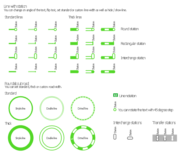
Metro map shapes
Metro map shapes, transfer station, station, roundabout, roundabout road, roundabout, line, station, line notation, interchange station,
Used Solutions

How to draw Metro Map style infographics? (Moscow)

Tool to draw Metro Map styled inforgraphics. Moscow Metro sample.

Map Infographic Design

ConceptDraw collection of vector elements for infographics design.

How can you illustrate the weather condition

Use it to make professional looking documents, presentations, and websites illustrated with color scalable vector clipart for geography, weather, and animals.

Types of Map - Overview

ConceptDraw defines some map types, divided into three categories. Every map type has specific shapes and examples.

Vector Map of Germany

Vector map is the best way to visually present a world, continents, islands, to display location and boundaries of countries and cities. ConceptDraw DIAGRAM diagramming and vector drawing software offers the Germany Map Solution from the Maps Area of ConceptDraw Solution Park - the best tool for fast and easy drawing vector map of Germany of any degree of detailing, and thematic cartograms and maps of Germany on its base.

Excellent Examples of Infographic Maps

Create Spatial infographics with ConceptDraw using its excellent examples of infographic maps. We hope these can inspire and teach you!