This site uses cookies. By continuing to browse the ConceptDraw site you are agreeing to our Use of Site Cookies.

Infographic software: the sample of New York City Subway map

Tool to draw Metro Map styled inforgraphics. New York City Subway map sample.

Maps of Germany With Cities

Despite the fact that the maps surround us everywhere in our life, usually the process of their drawing is sufficienly complex and labor-intensive. But now, thanks to the ConceptDraw DIAGRAM diagramming and vector drawing software extended with Germany Map Solution from the Maps Area of ConceptDraw Solution Park, we have the possibility to make easier this process. Design fast and easy your own pictorial maps of Germany, map of Germany with cities, and thematic Germany maps in ConceptDraw DIAGRAM!

Map of Germany

Germany, officially the Federal Republic of Germany, is a federal parliamentary republic in West-Central Europe. You need design the map of Germany or detailed map of Germany with cities fast and easy? We reccomend you to use the indispensable ConceptDraw DIAGRAM diagramming and vector drawing software extended with unique Germany Map Solution from the Maps Area of ConceptDraw Solution Park.
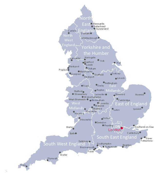
This political map example shows English regions, cities and towns.
"England is a country that is part of the United Kingdom. It shares land borders with Scotland to the north and Wales to the west. The Irish Sea lies northwest of England and the Celtic Sea lies to the southwest. England is separated from continental Europe by the North Sea to the east and the English Channel to the south. The country covers much of the central and southern part of the island of Great Britain, which lies in the North Atlantic; and includes over 100 smaller islands such as the Isles of Scilly, and the Isle of Wight. ...
The subdivisions of England consist of up to four levels of subnational division controlled through a variety of types of administrative entities created for the purposes of local government. The highest tier of local government were the nine regions of England: North East, North West, Yorkshire and the Humber, East Midlands, West Midlands, East, South East, South West, and London. ...
There are fifty settlements which have been designated city status in England, while the wider United Kingdom has sixty-six.
While many cities in England are quite large in size, such as Birmingham, Sheffield, Manchester, Liverpool, Leeds, Newcastle, Bradford, Nottingham and others, a large population is not necessarily a prerequisite for a settlement to be afforded city status. Traditionally the status was afforded to towns with diocesan cathedrals and so there are smaller cities like Wells, Ely, Ripon, Truro and Chichester." [England. Wikipedia]
The political map example "English cities and towns map" was drawn using ConceptDraw PRO software extended with the Map of UK solution from the Maps area of ConceptDraw Solution Park.
English regions map
English regions map, Yorkshire and the Humber, West Midlands, South West England, South East England, North West England, North East England, Greater London, England regions and cities, England, East of England, East Midlands,
Used Solutions

Map of Germany — Hamburg

Hamburg is the second largest city in Germany and the eighth largest city in the European Union. It is the second smallest German state by area.
Despite the fact that the maps surround us everywhere in our life, usually the process of their drawing is sufficienly complex and labor-intensive. But now, thanks to the ConceptDraw DIAGRAM diagramming and vector drawing software extended with Germany Map Solution from the Maps Area of ConceptDraw Solution Park, we have the possibility to make easier this process. Design fast and easy your own pictorial maps of Germany, map of Germany with cities, and thematic Germany maps in ConceptDraw DIAGRAM!

How to draw Metro Map style infographics? (New York)

How to draw Metro Map style infographics of New York subway.
New York Subway has a long history starting on October 27, 1904. Since the opening many agencies have provided schemes of the subway system. At present time are 34 lines in use. This page present New York City subway map construct with Metro Map Solution in Conceptdraw DIAGRAM software. This is a one-click tool to add stations to the map. It lets you control the direction in which you create new stations, change lengths, and add text labels and icons. It contains Lines, Stations, and Landmarks objects

Metro Map

ConceptDraw Metro Maps solution is a one-click tool to add stations to the metro map. It lets you control the direction in which you create new stations, change lengths, and add text labels and icons. It contains Lines, Stations, and Landmarks objects.
The Metro Map Solution from the Maps Area uses two ConceptDraw techniques: Replicating Objects and Switching Objects. And the result is a vector graphic document.

Australia Map — Victoria

Victoria (abbreviated as Vic) is a state in the south-east of Australia. Victoria is Australia's most densely populated state and its second-most populous state overall.
Maps surround us everywhere in our life, study, work, traveling, they are widely used in geography, history, politics, economics, and many other fields of science and life activity. But designing of maps is usually complex and labor-intensive process. Now we have the possibility to make easier this process - ConceptDraw DIAGRAM diagramming and vector drawing software extended with Australia Map Solution from the Maps Area of ConceptDraw Solution Park will help us in easy drawing detailed Australia map.

Map of Germany — Bavaria State

Bavaria is a federal state of Germany. In the southeast of the country with an area of 70,548 square kilometres.
Despite the fact that the maps surround us everywhere in our life, usually the process of their drawing is sufficienly complex and labor-intensive. But now, thanks to the ConceptDraw DIAGRAM diagramming and vector drawing software extended with Germany Map Solution from the Maps Area of ConceptDraw Solution Park, we have the possibility to make easier this process. Design fast and easy your own pictorial maps of Germany, map of Germany with cities, and thematic Germany maps in ConceptDraw DIAGRAM!

Map of Germany — Bremen

The City Municipality of Bremen is a Hanseatic city in northwestern Germany. The Free Hanseatic City of Bremen is the smallest of Germany's 16 states.
Despite the fact that the maps surround us everywhere in our life, usually the process of their drawing is sufficienly complex and labor-intensive. But now, thanks to the ConceptDraw DIAGRAM diagramming and vector drawing software extended with Germany Map Solution from the Maps Area of ConceptDraw Solution Park, we have the possibility to make easier this process. Design fast and easy your own pictorial maps of Germany, map of Germany with cities, and thematic Germany maps in ConceptDraw DIAGRAM!

Australia Map — New South Wales

New South Wales (abbreviated as NSW) is a state on the east coast of Australia.
Maps surround us everywhere in our life, study, work, traveling, they are widely used in geography, history, politics, economics, and many other fields of science and life activity. But designing of maps is usually complex and labor-intensive process. Now we have the possibility to make easier this process - ConceptDraw DIAGRAM diagramming and vector drawing software extended with Australia Map Solution from the Maps Area of ConceptDraw Solution Park will help us in easy drawing detailed Australia map.

Map of Scotland

Scotland is a country that is part of the United Kingdom and covers the northern third of the island of Great Britain.
ConceptDraw DIAGRAM diagramming and vector drawing software extended with powerful Map of UK Solution from the Maps Area of ConceptDraw Solution Park is the best for drawing various kinds of United Kingdom maps, map of Scotland, map of England, map of Wales, Northern Ireland map, thematic UK maps of any detailing and geospatial infographics.

Subway Map

ConceptDraw DIAGRAM diagramming and vector drawing software is the best choice for making professional looking Subway Map. ConceptDraw DIAGRAM provides Metro Map Solution from the Maps Area of ConceptDraw Solution Park.

Map of UK — Great Britain Cities

Great Britain, also known as Britain, is an island in the North Atlantic off the north-west coast of continental Europe. With an area of 209,331 km2 (80,823 sq mi), it is the largest island in Europe and the ninth-largest in the world.
How to design the Map of UK fast and easy? It is incredibly convenient to use special software. ConceptDraw DIAGRAM diagramming and vector drawing software offers the Map of UK Solution from the Maps Area of ConceptDraw Solution Park specially developed to make easier drawing the maps of UK counties, various UK related thematic maps and cartograms on their base.

Geo Map - Australia - Victoria

Victoria (abbreviated as Vic.) is a state in the south-east of Australia. Victoria is Australia's most densely populated state and its second-most populous state overall.

Geo Map - Asia - Philippines

The Philippines, officially known as the Republic of the Philippines, is a sovereign island country in Southeast Asia situated in the western Pacific Ocean.
Use the Continent Maps solution and Philippines library to draw thematic maps, geospatial infographics and vector illustrations. This solution to help visualize the business and thematic information connected with geographic areas, locations or customs; for your business documents, presentations and websites.

Map of Germany — Brandenburg State

Brandenburg is one of the sixteen federated states of Germany. It lies in the northeast of the country covering an area of 29,478 square kilometers and has 2.45 million inhabitants.
Despite the fact that the maps surround us everywhere in our life, usually the process of their drawing is sufficienly complex and labor-intensive. But now, thanks to the ConceptDraw DIAGRAM diagramming and vector drawing software extended with Germany Map Solution from the Maps Area of ConceptDraw Solution Park, we have the possibility to make easier this process. Design fast and easy your own pictorial maps of Germany, map of Germany with cities, and thematic Germany maps in ConceptDraw DIAGRAM!

Map Infographic Design

ConceptDraw collection of vector elements for infographics design.

Geo Map — USA — Oklahoma

Oklahom is a state located in the South Central United States.
The vector stencils library Oklahoma contains contours for ConceptDraw DIAGRAM diagramming and vector drawing software. This library is contained in the Continent Maps solution from Maps area of ConceptDraw Solution Park.

Australia Map — States and Cities

Maps surround us everywhere in our life, study, work, traveling, they are widely used in geography, history, politics, economics, and many other fields of science and life activity. But designing of maps is usually complex and labor-intensive process. Now we have the possibility to make easier this process - ConceptDraw DIAGRAM diagramming and vector drawing software extended with Australia Map Solution from the Maps Area of ConceptDraw Solution Park will help us in easy drawing detailed Australia map.