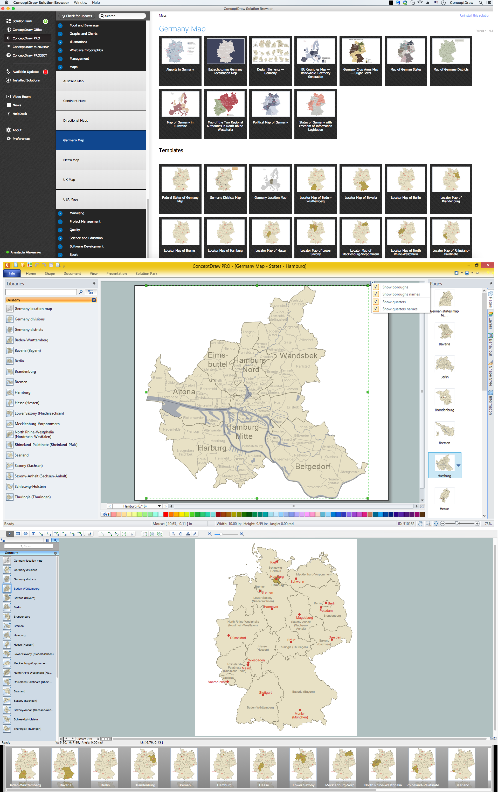
Map of Germany — Hamburg
“Hamburg is the second largest city in Germany and the eighth largest city in the European Union. It is the second smallest German state by area. Its population is over 1.7 million people, and the Hamburg Metropolitan Region (including parts of the neighbouring Federal States of Lower Saxony and Schleswig-Holstein) has more than 5 million inhabitants. The city is situated on the river Elbe.“
Boroughs
- Hamburg-Mitte
- Altona
- Eimsbüttel
- Hamburg-Nord
- Wandsbek
- Bergedorf
- Harburg
Quarters
- Altona-Altstadt
- Altona-Nord
- Bahrenfeld
- Blankenese
- Groß Flottbek
- Iserbrook
- Lurup
- Nienstedten
- Osdorf
- Othmarschen
- Ottensen
- Rissen
- Sternschanze
- Sülldorf
- Allermöhe
- Altengamme
- Bergedorf
- Billwerder
- Curslack
- Kirchwerder
- Lohbrügge
- Moorfleet
- Neuallermöhe
- Neuengamme
- Ochsenwerder
- Reitbrook
- Spadenland
- Tatenberg
- Eidelstedt
- Eimsbüttel
- Harvestehude
- Hoheluft-West
- Lokstedt
- Niendorf
- Rotherbaum
- Schnelsen
- Stellingen
- Billbrook
- Billstedt
- Borgfelde
- Finkenwerder
- HafenCity
- Hamburg-Altstadt
- Hamm
- Hammerbrook
- Horn
- Kleiner Grasbrook
- Neustadt
- Neuwerk
- Rothenburgsort
- Steinwerder
- St. Georg
- St. Pauli
- Veddel
- Waltershof
- Wilhelmsburg
- Alsterdorf
- Barmbek-Nord
- Barmbek-Süd
- Dulsberg
- Eppendorf
- Fuhlsbüttel
- Groß Borstel
- Hoheluft-Ost
- Hohenfelde
- Langenhorn
- Ohlsdorf
- Uhlenhorst
- Winterhude
- Altenwerder
- Cranz
- Eißendorf
- Francop
- Gut Moor
- Harburg
- Hausbruch
- Heimfeld
- Langenbek
- Marmstorf
- Moorburg
- Neuenfelde
- Neugraben-Fischbek
- Neuland
- Rönneburg
- Sinstorf
- Wilstorf
- Bergstedt
- Bramfeld
- Duvenstedt
- Eilbek
- Farmsen-Berne
- Hummelsbüttel
- Jenfeld
- Lemsahl-Mellingstedt
- Marienthal
- Poppenbüttel
- Rahlstedt
- Sasel
- Steilshoop
- Tonndorf
- Volksdorf
- Wandsbek
- Wellingsbüttel
- Wohldorf-Ohlstedt