 Continent Maps
Continent Maps solution extends ConceptDraw PRO software with templates, samples and libraries of vector stencils for drawing the thematic maps of continents, state maps of USA and Australia.
Geo Map — Asia

Geo Map — United States of America Map

How to draw Metro Map style infographics? Moscow, New York, Los Angeles, London

A map showing European membership of the EU and NATO.
"The European Union (EU) is an economic and political union of 28 member states that are located primarily in Europe.
The EU operates through a system of supranational independent institutions and intergovernmental negotiated decisions by the member states. Institutions of the EU include the European Commission, the Council of the European Union, the European Council, the Court of Justice of the European Union, the European Central Bank, the Court of Auditors, and the European Parliament. The European Parliament is elected every five years by EU citizens. The EU's de facto capital is Brussels." [European Union. Wikipedia]
"The principal military alliance in Europe remains NATO, which includes 21 of all EU member states as well as other non-EU European countries, Turkey, the United States and Canada." [Military of the European Union. Wikipedia]
"The North Atlantic Treaty Organization (NATO), also called the (North) Atlantic Alliance, is an intergovernmental military alliance based on the North Atlantic Treaty which was signed on 4 April 1949. The organization constitutes a system of collective defence whereby its member states agree to mutual defense in response to an attack by any external party. NATO's headquarters are in Brussels, Belgium, one of the 28 member states across North America and Europe, the newest of which, Albania and Croatia, joined in April 2009." [NATO. Wikipedia]
This Europe map example was redesigned using the ConceptDraw PRO diagramming and vector drawing software from the Wikimedia Commons file: EU and NATO.svg.
[commons.wikimedia.org/ wiki/ File:EU_ and_ NATO.svg]
The Europe political map example "European membership of the EU and NATO map" is included in the Continent Maps solution from the Maps area of ConceptDraw Solution Park.
Political map - EU and NATO

Geo Map — South America Continent

 Metro Map
Metro Map solution extends ConceptDraw PRO software with templates, samples and library of vector stencils for drawing the metro maps, route maps, bus and other transport schemes, or design tube-style infographics.
Geo Map — Europe

Metro Maps

Geo Map - Africa

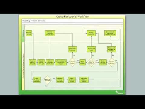
Cross-Functional Flowchart

 Quality Mind Map
This solution extends ConceptDraw MINDMAP software with Quality Management Mind Maps (Presentations, Meeting Agendas, Problem to be solved).
HelpDesk
How to Create a Directional Map Using ConceptDraw PRO

Concept Maps

Mind Map - Quality Structure

- Map of Germany | Geo Map - Asia - Philippines | Map of Continents ...
- Concept Maps | Internet marketing - Concept map | What Is a ...
- Drawing Of A Map Of East Africa
- Map Directions | How to draw Metro Map style infographics? (New ...
- Southern Cone - Political map | South America regions - Political ...
- Mind Map Food
- Geo Map - Asia - Indonesia
- Concept Maps | Concept Mapping | The Best Flowchart Software ...
- 3D pictorial road map | 2D Directional map - Template | Map ...
- What Is a Concept Map | Concept Maps | The Best Mac Software for ...
- Positioning Map | Infield Positioning for Baseball Situations | SWOT ...
- How to draw Metro Map style infographics? (Los Angeles) | How to ...
- Concept Map Generator
- Concept Maps | How To Make a Concept Map | Concept Map Maker ...
- Positioning map
- Metro Train Map
- Best Value Stream Mapping mac Software | Quality Mind Map ...
- Positioning map | Positioning Map | Business Tools Perceptual ...
- Geo Map - Europe
- How to Draw a Map of North America Using ConceptDraw PRO ...