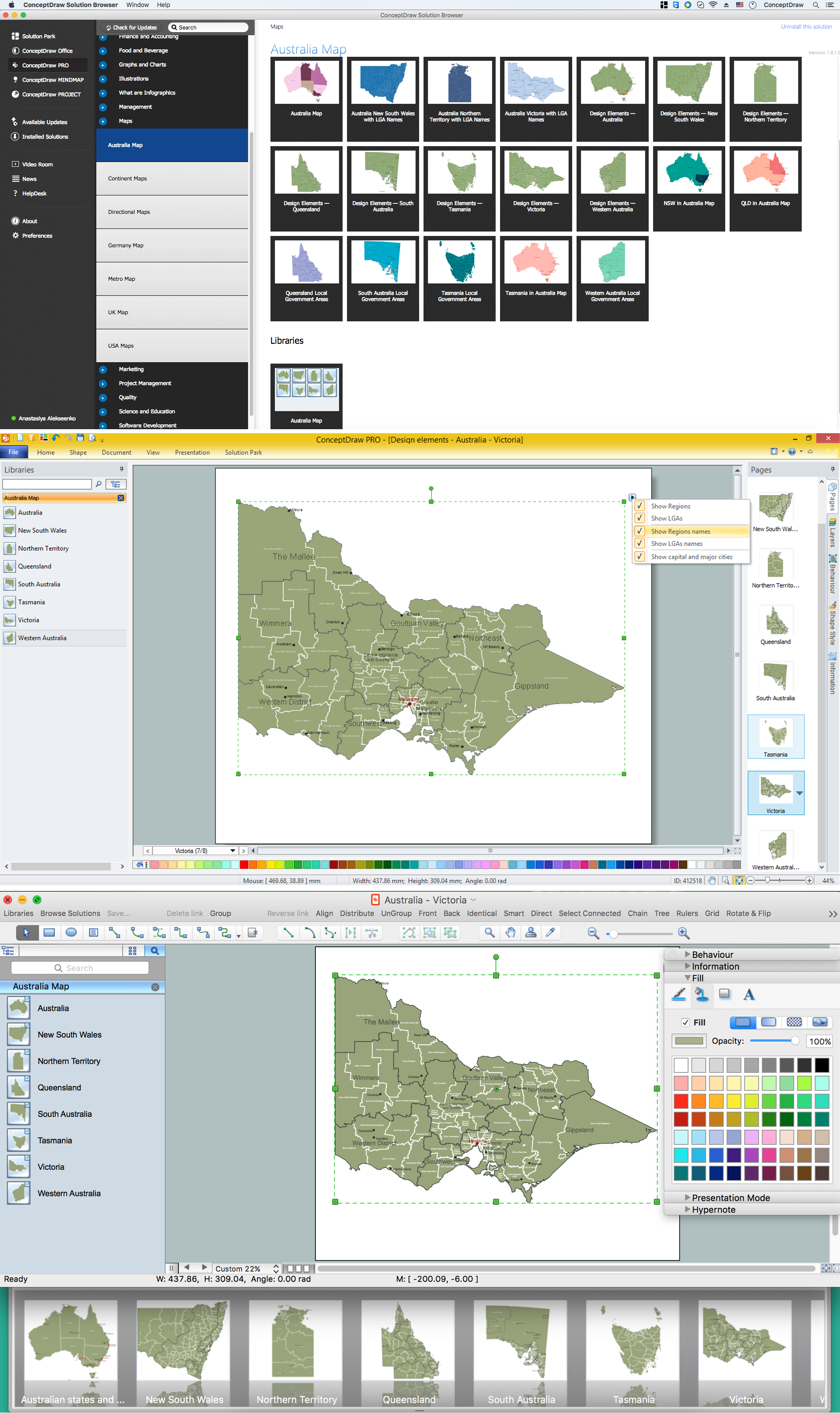
Australia Map — Victoria
“Victoria (abbreviated as Vic) is a state in the south-east of Australia. Victoria is Australia's most densely populated state and its second-most populous state overall. Most of its population is concentrated in the area surrounding Port Phillip Bay, which includes the metropolitan area of its capital and largest city, Melbourne, which is Australia's second-largest city. Geographically the smallest state on the Australian mainland, Victoria is bordered by Bass Strait and Tasmania to the south, New South Wales to the north, the Tasman Sea to the east, and South Australia to the west.“
Regions
- Central Highlands and Goldfields
- Gippsland
- Goulburn Valley
- Greater Melbourne
- Northeast
- Southwest
- The Mallee
- Western District
- Wimmera
Local Government Areas
- Alpine Shire
- Bass Coast Shire
- City of Ballarat
- City of Casey
- City of Greater Bendigo
- City of Greater Geelong
- City of Greater Shepparton
- City of Hume
- City of Latrobe
- City of Melton
- City of Whittlesea
- City of Wodonga
- City of Wyndham
- Colac Otway Shire
- Corangamite Shire
- French Island
- Golden Plains Shire
- Pyrenees Shire
- Rural City of Ararat
- Rural City of Benalla
- Rural City of Horsham
- Rural City of Mildura
- Rural City of Swan Hill
- Rural City of Wangaratta
- Shire of Baw Baw
- Shire of Buloke
- Shire of Campaspe
- Shire of Cardinia
- Shire of Central Goldfields
- Shire of East Gippsland
- Shire of Gannawarra
- Shire of Glenelg
- Shire of Hepburn
- Shire of Hindmarsh
- Shire of Indigo
- Shire of Loddon
- Shire of Macedon Ranges
- Shire of Mansfield
- Shire of Mitchell
- Shire of Moira
- Shire of Moorabool
- Shire of Mount Alexander
- Shire of Moyne
- Shire of Murrindindi
- Shire of Nillumbik
- Shire of Northern Grampians
- Shire of Southern Grampians
- Shire of Strathbogie
- Shire of Towong
- Shire of Wellington
- Shire of West Wimmera
- Shire of Yarra Ranges
- Shire of Yarriambiack
- South Gippsland Shire
- Surf Coast Shire