Geo Map - South America - Cuba
Maps of South America - Republic of Cuba
"Cuba, officially the Republic of Cuba, is an island country in the Caribbean. The nation of Cuba comprises the main island of Cuba, the Isla de la Juventud, and several archipelagos. Havana is the capital of Cuba and its largest city. The second largest city is Santiago de Cuba. To the north of Cuba lies the United States (150 km or 93 mi away) and the Bahamas are to the northeast, Mexico is to the west (200 km or 120 mi away), the Cayman Islands and Jamaica are to the south, and Haiti and the Dominican Republic are to the southeast." [Cuba. Wikipedia]
The vector stencils library Cuba contains contours for ConceptDraw DIAGRAM diagramming and vector drawing software. This library is contained in the Continent Maps solution from Maps area of ConceptDraw Solution Park.

Use the Cuba library to draw thematic maps, geospatial infographics and vector illustrations for your business documents, presentations and websites.
Geo Map - South America - Republic of Cuba

Geo Map - South America - Cuba Contour

Geo Map - South America

Geo Map - South America Contour

Geo Map - contours of South America countries

See also Geo Maps of South America Countries :
EIGHT RELATED HOW TO's:
No one can imagine a geography class without such educational stuff as a geo map or a globe. As for one of the biggest countries in North America, the United States of America Map is present in every American school or college. It’s easier to remember all the states if you look on the map more often.
The following sample represents the map of USA. This precise map has names of all states of America. The different colors which are used to indicate each state add the visuality and brightness to the whole map. The ConceptDraw USA Maps solution - one of a family of ConceptDraw Maps solutions. Any country invokes a big piece of data: geographical, political, statistical, etc. A simple way of representing this data is to design maps that will show a certain item in relation to a particular area of Earth.
Picture: How to Draw the US Map? ConceptDraw Diagram Software for Easy USA Map Drawing
Related Solution:
Nicaragua, officially the Republic of Nicaragua, is the largest country in the Central American isthmus, bordering Honduras to the north and Costa Rica to the south.
The vector stencils library Nicaragua contains contours for ConceptDraw DIAGRAM diagramming and vector drawing software. This library is contained in the Continent Maps solution from Maps area of ConceptDraw Solution Park.
Picture: Geo Map - South America - Nicaragua
Related Solution:
Bolivia, officially known as the Plurinational State of Bolivia, is a landlocked country located in central South America.
The vector stencils library Bolivia contains contours for ConceptDraw DIAGRAM diagramming and vector drawing software. This library is contained in the Continent Maps solution from Maps area of ConceptDraw Solution Park.
Picture: Geo Map - South America - Bolivia
Related Solution:
Haiti, officially the Republic of Haiti, is a Caribbean country.
The vector stencils library Haiti contains contours for ConceptDraw DIAGRAM diagramming and vector drawing software. This library is contained in the Continent Maps solution from Maps area of ConceptDraw Solution Park.
Picture: Geo Map - South America - Haiti
Related Solution:
A flowchart is a picture of the separate steps of a process in sequential order.
ConceptDraw DIAGRAM is a Process Flowcharts software. This software includes basic package of process flow examples. The software contains object libraries with vector stencils that allows you use RapidDraw technology. By clicking on direction arrows you can add a new object to the flowchart.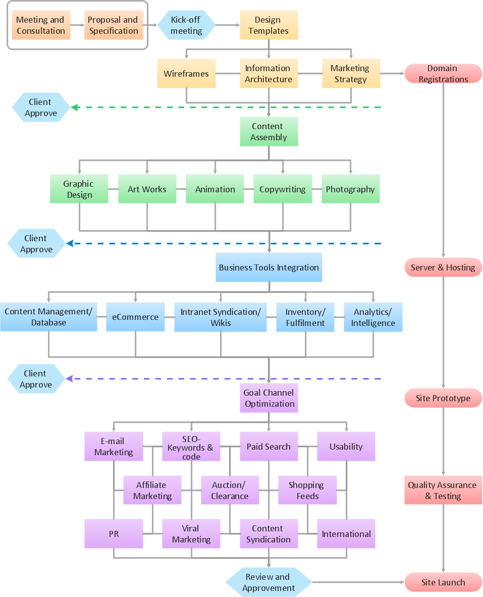
Picture: Example Process Flow
Related Solution:
New Mexico is a state located in the southwest and western regions of the United States.
The vector stencils library New Mexico contains contours for ConceptDraw DIAGRAM diagramming and vector drawing software. This library is contained in the Continent Maps solution from Maps area of ConceptDraw Solution Park.
Picture: Geo Map — USA — New Mexico
Related Solution:
Guatemala, officially the Republic of Guatemala, is a country in Central America bordered by Mexico to the north and west, the Pacific Ocean to the southwest, Belize to the northeast, the Caribbean to the east, Honduras to the east and El Salvador to the southeast.
The vector stencils library Guatemala contains contours for ConceptDraw DIAGRAM diagramming and vector drawing software. This library is contained in the Continent Maps solution from Maps area of ConceptDraw Solution Park.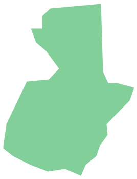
Picture: Geo Map - South America - Guatemala
Related Solution:
Guyana, officially the Co-operative Republic of Guyana, is a sovereign state on the northern coast of South America.
The vector stencils library Guyana contains contours for ConceptDraw DIAGRAM diagramming and vector drawing software. This library is contained in the Continent Maps solution from Maps area of ConceptDraw Solution Park.
Picture: Geo Map - South America - Guyana
Related Solution:


