 Metro Map
Metro Map solution extends ConceptDraw DIAGRAM software with templates, samples and library of vector stencils for drawing the metro maps, route maps, bus and other transport schemes, or design tube-style infographics.
Metro Maps

Metro Map

Subway Map

How to draw Metro Map style infographics? (New York)
</i> *")
Infographic software: the sample of New York City Subway map

How to draw Metro Map style infographics? Moscow, New York, Los Angeles, London

Subway infographic design elements - software tools

How to draw Metro Map style infographics? (London)
</i> *")
MTA Subway Map

Infographic design elements, software tools Subway and Metro style

Subway Train Map

How to draw Metro Map style infographics? (Los Angeles)

The vector stencils library Map symbols contains 19 icons for labeling the maps using the ConceptDraw PRO diagramming and vector drawing software.
The vector stencils library Subway map contains 41 shapes for creating the subway (tube, metro) maps using the ConceptDraw PRO.
"The various features shown on a map are represented by conventional signs or symbols. For example, colors can be used to indicate a classification of roads. Those signs are usually explained in the margin of the map, or on a separately published characteristic sheet.
Some cartographers prefer to make the map cover practically the entire screen or sheet of paper, leaving no room "outside" the map for information about the map as a whole. These cartographers typically place such information in an otherwise "blank" region "inside" the map -- cartouche, map legend, title, compass rose, bar scale, etc. In particular, some maps contain smaller "sub-maps" in otherwise blank regions—often one at a much smaller scale showing the whole globe and where the whole map fits on that globe, and a few showing "regions of interest" at a larger scale in order to show details that wouldn't otherwise fit." [Map. Wikipedia]
The example "Design elements - Subway map, Map symbols" is included in the Directional Maps solution from the Maps area of ConceptDraw Solution Park.
Map symbols

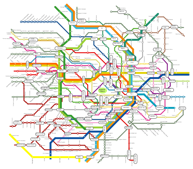
"The Tokyo subway is a part of the extensive rapid transit system in the Greater Tokyo area of Japan. While the subway system itself is largely within the city center, the lines extend far out via extensive through services onto suburban railway lines. ...
There are two primary subway operators in Tokyo:
(1) Tokyo Metro – Formerly the Teito Rapid Transit Authority (TRTA), it was privatized in 2004. It currently operates 179 stations on nine lines and 195.1 kilometers (121.2 mi) of route.
(2) Toei Subway – run by the Tokyo Metropolitan Bureau of Transportation, an agency of the Tokyo Metropolitan Government. It operates 106 stations on four lines.
As of 2013, the combined subway network of the Tokyo and Toei metros comprises 290 stations and 13 lines." [Tokyo subway. Wikipedia]
The example "Tokyo subway map" was created using the ConceptDraw PRO diagramming and vector drawing software extended with the Metro Map solution from the Maps area of ConceptDraw Solution Park.
Tokyo subway map
Metro Train Map

Metro Path Map

"The Tokyo subway is a part of the extensive rapid transit system in the Greater Tokyo area of Japan. While the subway system itself is largely within the city center, the lines extend far out via extensive through services onto suburban railway lines. ...
There are two primary subway operators in Tokyo:
(1) Tokyo Metro – Formerly the Teito Rapid Transit Authority (TRTA), it was privatized in 2004. It currently operates 179 stations on nine lines and 195.1 kilometers (121.2 mi) of route.
(2) Toei Subway – run by the Tokyo Metropolitan Bureau of Transportation, an agency of the Tokyo Metropolitan Government. It operates 106 stations on four lines.
As of 2013, the combined subway network of the Tokyo and Toei metros comprises 290 stations and 13 lines." [Tokyo subway. Wikipedia]
The example "Tokyo subway map" was created using the ConceptDraw PRO diagramming and vector drawing software extended with the Metro Map solution from the Maps area of ConceptDraw Solution Park.
There are two primary subway operators in Tokyo:
(1) Tokyo Metro – Formerly the Teito Rapid Transit Authority (TRTA), it was privatized in 2004. It currently operates 179 stations on nine lines and 195.1 kilometers (121.2 mi) of route.
(2) Toei Subway – run by the Tokyo Metropolitan Bureau of Transportation, an agency of the Tokyo Metropolitan Government. It operates 106 stations on four lines.
As of 2013, the combined subway network of the Tokyo and Toei metros comprises 290 stations and 13 lines." [Tokyo subway. Wikipedia]
The example "Tokyo subway map" was created using the ConceptDraw PRO diagramming and vector drawing software extended with the Metro Map solution from the Maps area of ConceptDraw Solution Park.
Tokyo subway map
Spatial infographics Design Elements: Continental Map

Map Infographic Design

- Subway Train Map | How to draw Metro Map style infographics ...
- Design elements - Subway map , Map symbols
- Map Infographic Creator | Subway Map Creator Software Free
- Tokyo subway map
- Subway Train Map
- How to draw Metro Map style infographics? (Los Angeles) | How to ...
- Mta Subway Map Vector
- Design elements - Subway map , Map symbols | How to draw Metro ...
- How to draw Metro Map style infographics? Moscow, New York, Los ...
- Metro Map | How to draw Metro Map style infographics? Moscow ...
- New York City Subway map
- Metro Maps | How to draw Metro Map style infographics? Moscow ...
- ConceptDraw News | Navigate the World with Metro Maps
- MTA Subway Map
- Metro Maps
- Design elements - Metro maps
- How to draw Metro Map style infographics? (London) | How to draw ...
- Design elements - Subway map , Map symbols | Landmarks - Vector ...
- How to draw Metro Map style infographics? (New York) | Subway ...
- Metro Map | Transit map template | Transport map - Template ...