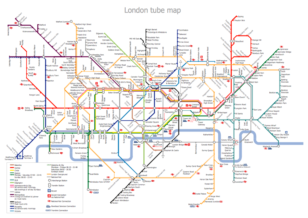
Example 1. Metro Path Map
The simplest way of Metro Path Map creating is to open the ConceptDraw STORE and to choose one of the samples or template offered by Metro Map Solution. Then you can simply make some changes in it according to your needs.

Example 2. Metro Map Solution in ConceptDraw STORE
Designing a Metro Path Map, use also ready vector objects offered by Transport Map library from the Metro Map Solution.

Example 3. Metro Path Map - ALR Route Map
The Metro Path Map samples you see on this page were created in ConceptDraw DIAGRAM software using the predesigned shapes from the Transport Map library of Metro Map solution. They successfully demonstrate solution's capabilities and professional results you can achieve using it.
Use the tools of Metro Map solution for fast and easy drawing any Metro Path Map you need.
All source documents are vector graphic documents. They are available for reviewing, modifying, or converting to a variety of formats (PDF file, MS PowerPoint, MS Visio, and many other graphic formats) from the ConceptDraw STORE. The Metro Map Solution is available for all ConceptDraw DIAGRAM or later users.
FOUR RELATED HOW TO's:
Drawing of Metro Train Map is usually complex process, but we want to make it easier and offer you the ConceptDraw DIAGRAM software with its Metro Map Solution from the Maps Area of ConceptDraw Solution Park.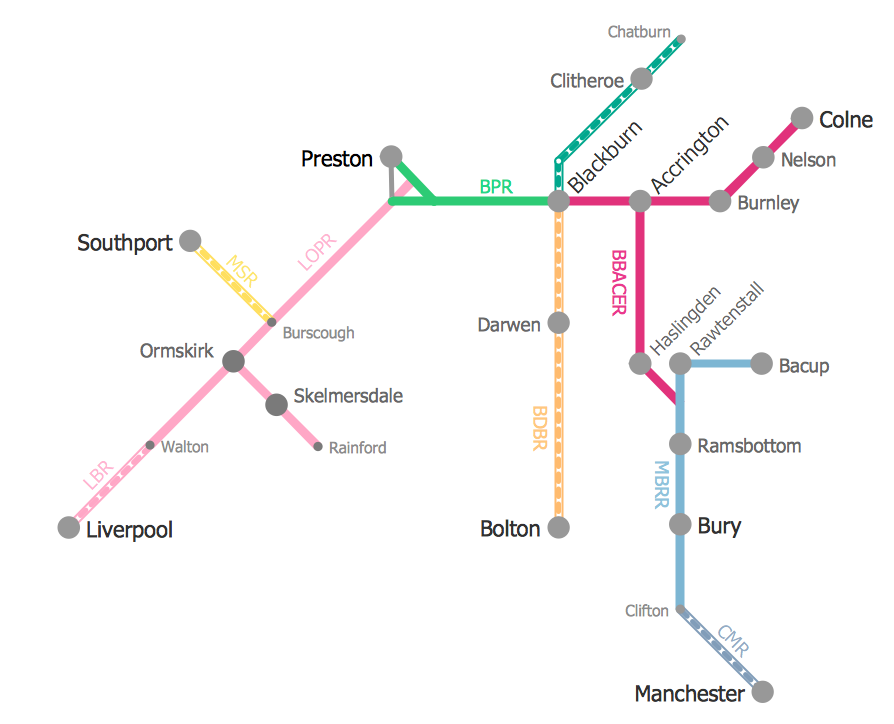
Picture: Metro Train Map
Related Solution:
How to draw Metro Map style infographics of New York subway.
New York Subway has a long history starting on October 27, 1904. Since the opening many agencies have provided schemes of the subway system. At present time are 34 lines in use. This page present New York City subway map construct with Metro Map Solution in Conceptdraw DIAGRAM software. This is a one-click tool to add stations to the map. It lets you control the direction in which you create new stations, change lengths, and add text labels and icons. It contains Lines, Stations, and Landmarks objects
Picture: How to draw Metro Map style infographics? (New York)
Related Solution:
This sample was created in ConceptDraw DIAGRAM diagramming and vector drawing software using the Computer and Networks solution from Computer and Networks area of ConceptDraw Solution Park.
A Daisy Chain is the simple computer network. It is the easiest way to add more Ethernet devices into the network. In the Daisy Chain network one computer is connected to the next without any intervening devices, thus the message is sent from one computer to the next and then to the next and so on. A Daisy Chain can be linear or ring
Picture: Daisy Chain Network Topology
Related Solution:
Despite the fact that the maps surround us everywhere in our life, usually the process of their drawing is sufficienly complex and labor-intensive. But now, thanks to the ConceptDraw DIAGRAM diagramming and vector drawing software extended with Germany Map Solution from the Maps Area of ConceptDraw Solution Park, we have the possibility to make easier this process. Design fast and easy your own pictorial maps of Germany, map of Germany with cities, and thematic Germany maps in ConceptDraw DIAGRAM!
Picture: Maps of Germany With Cities
Related Solution:

