 Metro Map
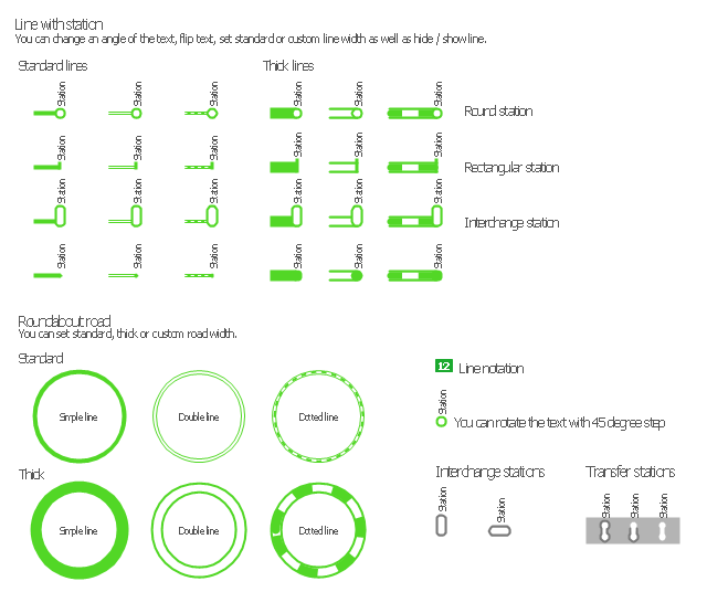
Metro Map solution extends ConceptDraw PRO software with templates, samples and library of vector stencils for drawing the metro maps, route maps, bus and other transport schemes, or design tube-style infographics.
How to draw Metro Map style infographics? (New York)

New York Subway has a long history starting on October 27, 1904. Since the opening many agencies have provided schemes of the subway system. At present time are 34 lines in use. This page present New York City subway map construct with Metro Map Solution in Conceptdraw PRO software. This is a one-click tool to add stations to the map. It lets you control the direction in which you create new stations, change lengths, and add text labels and icons. It contains Lines, Stations, and Landmarks objects
How to draw Metro Map style infographics? Moscow, New York, Los Angeles, London

Metro Map

The Metro Map Solution from the Maps Area uses two ConceptDraw techniques: Replicating Objects and Switching Objects. And the result is a vector graphic document.
How to draw Metro Map style infographics? (London)

Subway infographic design elements - software tools

The vector stencils library "Transport maps" contains 34 shapes for designing the transportation maps, metro maps, subway maps, underground maps, tube maps using the ConceptDraw PRO diagramming and vector drawing software extended with the Metro Map solution from the Maps area of ConceptDraw Solution Park.
Metro map shapes
 ConceptDraw Solution Park
ConceptDraw Solution Park collects graphic extensions, examples and learning materials
How to draw Metro Map style infographics? (Los Angeles)

This is a one-click tool to add stations to the map. It lets you control the direction in which you create new stations, change lengths, and add text labels and icons. It contains Lines, Stations, and Landmarks objects.
Metro Path Map

MTA Subway Map

This spatial infographic example was created on the base of the tube map from the Transport for London website.
[tfl.gov.uk/ assets/ images/ general/ 24746-nle-gallery-tube-map.jpg]
"The Tube map is a schematic transit map of the lines and stations of London's public rapid transit railway systems, namely the London Underground (commonly known as the Tube, hence the name), Docklands Light Railway, London Overground and Emirates Air Line, as well as being incorporated into Greater London connections maps.
As a schematic diagram, it shows not necessarily the geographic but rather the relative positions of stations along the lines, stations' connective relations with each other and fare zones. The basic design concepts have been widely adopted for other network maps around the world, especially that of mapping topologically rather than geographically." [Tube map. Wikipedia]
The spatial infographics example "Metro map - Northern line extension to Battersea via Nine Elms" was created using the ConceptDraw PRO diagramming and vector drawing software extended with the Spatial Infographics solution from the area "What is Infographics" of ConceptDraw Solution Park.
Tube map

Infographic design elements, software tools Subway and Metro style

Excellent Examples of Infographic Maps

 Value Stream Mapping
Value stream mapping solution extends ConceptDraw PRO software with templates, samples and vector stencils for drawing the Value Stream Maps (VSM) in lean manufacturing practice.
 Crystal Mapping
With Crystal Mapping all goals and relevant information can be observed in one radiant dashboard.
 Quality Mind Map
This solution extends ConceptDraw MINDMAP software with Quality Management Mind Maps (Presentations, Meeting Agendas, Problem to be solved).
Types of Map - Overview

 Directional Maps
Directional Maps solution extends ConceptDraw PRO software with templates, samples and libraries of vector stencils for drawing the directional, location, site, transit, road and route maps, plans and schemes.
 Continent Maps
Continent Maps solution extends ConceptDraw PRO software with templates, samples and libraries of vector stencils for drawing the thematic maps of continents, state maps of USA and Australia.
- Metro Map | Best Value Stream Mapping mac Software | Subway ...
- Maps | How to draw Metro Map style infographics? (London) | How ...
- Metro Map | Maps | How to draw Metro Map style infographics ...
- Value Stream Mapping | Maps | Metro Map | Conceptdraw Maps Map
- Metro Map | Concept maps with ConceptDraw PRO | Value Stream ...
- Map Infographic Creator | How to draw Metro Map style infographics ...
- Metro Map | How to draw Metro Map style infographics? Moscow ...
- Maps | Enhancing maps using ConceptDraw MINDMAP′s Theme ...
- Maps | Spatial infographics Design Elements: Transport Map | Metro ...
- Transport map template | Maps | Metro Map | Transport Map Template
- Value Stream Mapping | How to draw Metro Map style infographics ...
- Concept Maps | Basic Diagramming | Metro Map | Create Concept ...
- Maps | Transit map template | Metro Map | Transit Map
- Universal Diagramming Area | Metro Map | Computer and Networks ...
- Spatial infographics Design Elements: Transport Map | Maps | Metro ...
- How to draw Metro Map style infographics? (London) | London tube ...
- How to draw Metro Map style infographics? (New York) | Infographic ...
- Metro Map | Design elements - Metro maps | How to draw Metro Map ...
- How to draw Metro Map style infographics? (London) | Infographic ...
- How to draw Metro Map style infographics? (London) | How to draw ...