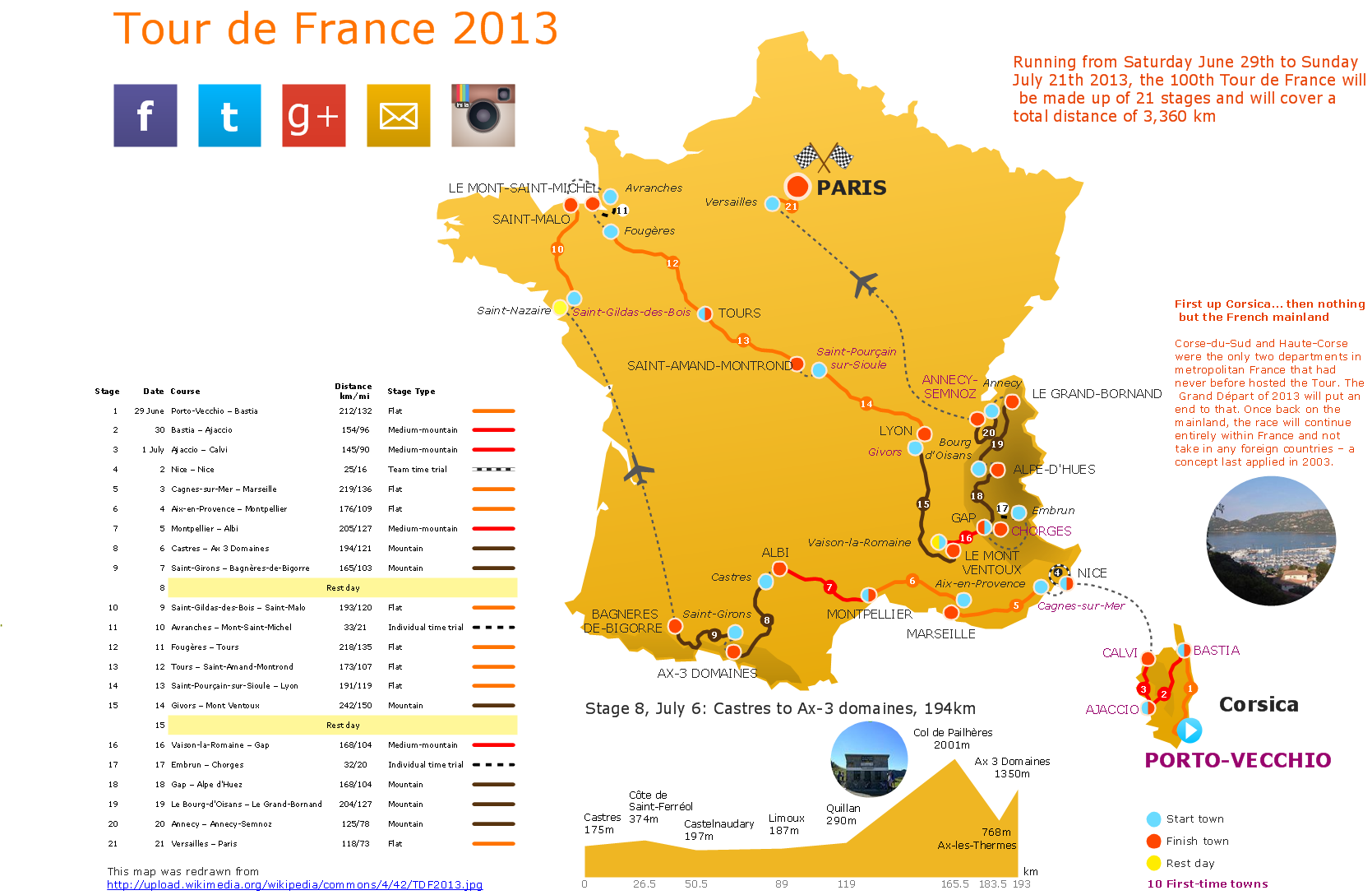
Geo Map — Europe — Germany
Maps of Europe — Federal Republic of Germany
Germany is a country in the west-central part of Europe. It borders with Poland to the east, Denmark to the north, Belgium to the west as well as Luxemburg, Switzerland to the south-southwest, the Netherlands to the northwest and Austria to the southeast. It is also bordered by the Baltic Sea as well as the North Sea. There is a fresh-water Lake Constance, part of which is within the borders of Germany and this lake is known to be the third largest one among the other in Central Europe. The territory of this country covers about 357000 square kilometres, where 349223 square kilometres is land and 7798 square kilometres is water. Germany is on the seventh place among other largest countries by their area in Europe. It is also on the 62nd place among the other large countries in the whole world.
There are the mountains of the Alps with their highest point — the Zugspitze, which is at 2962 metres above the sea level. There is the North Sea, known in German as a “Nordsee” in the northwest of the country and there is also the Baltic Sea, known as “Ostsee” in the northeast. There are many natural resources, including coal, iron ore, timber, potash, lignite, salt, natural gas, uranium, nickel, copper, water and arable land can be found within the borders of this country.
The climate in the most parts of Germany has so-called “temperate seasonal climate” with the humid westerly winds. The winters can be very cold in Germany, although summers are usually very warm with long dry periods. In the central as well as the southern parts of Germany the climate varies from moderately oceanic to the continental one, although in the Alpine regions there is a “mountain climate”, which can become obvious when there are low temperatures with more precipitation to compare to the other regions of the country.
The territory of this country can be treated as if it had two so-called “eco-regions”. The first one is known to be a “Northeast-Atlantic shelf marine” one and the second seems to be known as the “European-Mediterranean montane mixed forests” one. Germany is covered by arable land, which is about 34% of the total territory of all country, and woodland and forest, which takes about 30% of the total territory. There are 16 national parks in this country, including the Vorpommern Lagoon Area National Park, the Jasmund National Park, the Wadden Sea National Park, the Muritz National Park, the Harz National Park, the Saxon Switzerland National Park, the Hainich National Park, the Bavarian Forest National Park, the Black Forest National Park, and so-called “Berchtesgaden National Park”. There are also 15 Biosphere Reserves and 98 nature parks within this country as well as over 400 zoos and animal parks.
There are many large cities in Germany, 34 of which have been identified as “regiopolis”. There are also 11 officially recognised “metropolitan regions”, the largest of which is the Rhine-Ruhr one, which includes the capital of the North Rhine-Westphalia – the city called Dusseldorf. Bochum, Cologne, Essen, Bonn, Duisburg and Dortmund are also included in this region. There are more than 3710000 people living in Berlin, which is the capital and the largest city in Germany. Next on the list of the largest cities in this country is Hamburg, where about 1787000 people live, next goes Munich with 1450000 residents, which is the biggest city in Bavaria. Cologne has over 1000000 people living there and there are over 732000 inhabitants in Frankfurt, which is a leading business centre in Europe and seat of the ECB.
Germany has a so-called “social market economy” having a very highly skilled labour force. Germany in general is on the third place among the largest exporters of goods in the world, having the largest national economy in Europe. It is also on the fourth place among the largest countries by their nominal GDP. It is on the fifth place on a list by PPP. One of the reasons of this country being that wealthy is that it provides the very good services in many of the spheres of business activity. Thus, its service sector contributes over 70% of the total GDP. Industry takes about 28% of all GDP and agriculture — only 1%.
Being a part of the European single market, Germany represents over 500 million consumers. This country is also a member of the Eurozone, representing around 338 million citizens. Working in the automotive industry, local people develop the modern cars, making Germany one of the most competitive and innovative in the world: the country, which takes the fourth place among the other large ones by production, producing and exporting chemical goods, machinery, electrical equipment, vehicles, electronic products, pharmaceuticals, transport equipment, basic metals, rubber, plastics and food products, being the world's third-largest arms exporter.
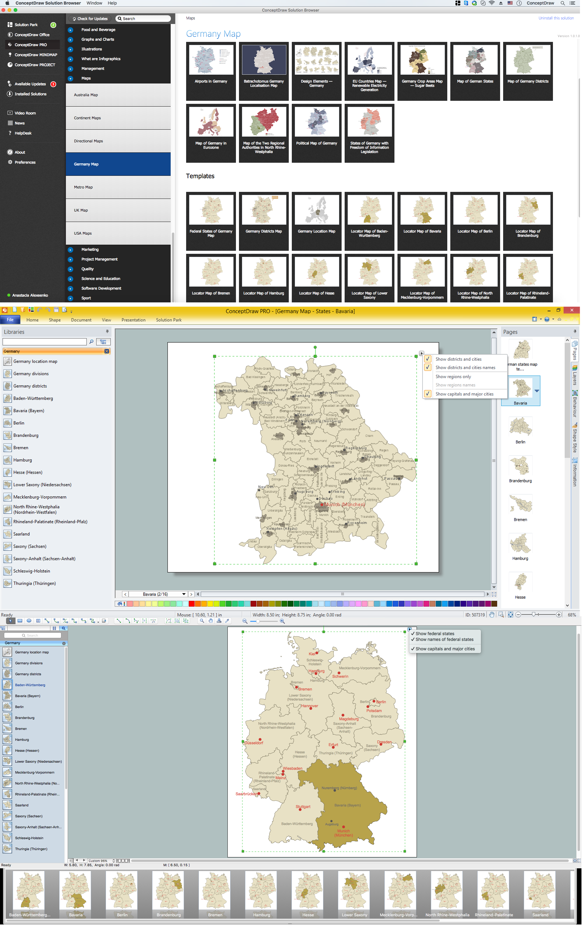
To describe this country even better, mentioning all of the needed numbers and statistics, it is always better to show the information on a map. Creating your own map of Germany can be a challenge, but once it has to be done in order to simplify the illustrating of the statistics about this country to use for your presentations, plans and projects, you can do it with the help of the professional software. One of the best nowadays for such purposes is ConceptDraw DIAGRAM application, which can be used as a graphical product, that is simple enough to understand and to draw any needed maps with the aid of the pre-made solutions within only a couple of hours, or even minutes.
Having ConceptDraw DIAGRAM software is always useful, especially if you decide to download also another product of CS Odessa, that is ConceptDraw STORE — the unique application, allowing to choose any needed solution among dozens of them, which were all previously developed in order to simplify the ConceptDraw DIAGRAM users’ work with their drawings. Each of the solutions has the needed tools for different purposes, which can be used to make the best and the most professionally looking maps, plans, charts as well as diagrams.
Thus, the “Continent Maps solution” from ConceptDraw STORE can be also downloaded from the “Maps area” of “ConceptDraw Solution Park” on this site, offering the vector stencils library “Germany”, which contains all of the needed contours of Germany, that can be used for creating different maps of this country using the ConceptDraw DIAGRAM diagramming and vector drawing software.

Pic. 1. Continent Maps Solution
Use the Germany library to draw thematic maps, geospatial infographics and vector illustrations for your business documents, presentations and websites.
Geo Map — Europe — Federal Republic of Germany
Germany has a population of over 81,4 million and an area 357,168 sq km(137,847 sq mi).

Pic. 2. Germany
Geo Map — Europe — Germany Contour
Capital — Berlin.

Pic. 3. Germany Contour
Geo Map — Europe
Europe is a continent that comprises the westernmost part of Eurasia.

Pic. 4. Europe Map
Geo Map — Europe Contour
A contour map is a map illustrated with contour lines.

Pic. 5. Europe Contour
Geo Map — contours of Europe countries
Use the map contours library "Europe" to design thematic maps using the ConceptDraw DIAGRAM diagramming and vector drawing software.
The vector stencils library "Europe" contains 44 map contours: Europe political map, map contours of countries.

Pic. 6. Contours of Europe countries
Geo Map — Europe flags

Pic. 7. Design elements — Europe flags
Geo Map - Map of Europe with Cities
This example is created using ConceptDraw DIAGRAM diagramming software enhanced with Continent Maps solution from ConceptDraw Solution Park.

Pic. 8. Map of Europe with Cities
All ConceptDraw DIAGRAM documents are vector graphic files and are available for reviewing, modifying, and converting to a variety of formats: image, HTML, PDF file, MS PowerPoint Presentation, Adobe Flash, MS Visio (.VDX, .VSDX).
See Also Maps of European Countries
- Albania
- Austria
- Belarus
- Bulgaria
- Bosnia and Herzegovina
- Belgium
- Czech Republic
- Croatia
- Denmark
- Estonia
- France
- Finland
- Greece
- Germany
- Hungary
- Italy
- Ireland
- Iceland
- United Kingdom
- Latvia
- Luxembourg
- Lithuania
- Montenegro
- Macedonia
- Moldova
- Norway
- Netherlands
- Portugal
- Poland
- Russia
- Romania
- Switzerland
- Sweden
- Spain
- Slovenia
- Slovakia
- Serbia
- Ukraine