Geo Map - Europe - Netherlands
Maps of Europe - Netherlands
"The Netherlands is a constituent country of the Kingdom of the Netherlands, consisting of twelve provinces in western Europe and three islands in the Caribbean. The European part of the Netherlands borders the North Sea to the north and west, Belgium to the south, and Germany to the east; and shares maritime borders with Belgium, Germany and the United Kingdom. The country is a parliamentary democracy organised as a unitary state. The capital city of the Netherlands, mandated by the constitution, is Amsterdam, however, the seat of government is located in The Hague. The Netherlands in its entirety is often referred to as Holland, which in strict usage, refers only to North and South Holland, two of its provinces; however the former usage is generally accepted." [Netherlands. Wikipedia]
The vector stencils library Netherlands contains contours for ConceptDraw DIAGRAM diagramming and vector drawing software. This library is contained in the Continent Maps solution from Maps area of ConceptDraw Solution Park.

Use the Netherlands library to draw thematic maps, geospatial infographics and vector illustrations for your business documents, presentations and websites.
Geo Map - Europe - Netherlands
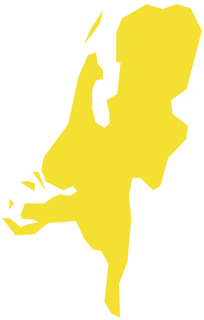
Geo Map - Europe - Netherlands Contour

Geo Map - Europe

Geo Map - Europe Contour

Geo Map - contours of Europe countries

See also Geo Maps of Europe Countries :
SEVEN RELATED HOW TO's:
Follow samples and map templates to create nfographic maps. It's super-easy!
Picture: Map Infographic Creator
The vector stencils library Italy contains contours for ConceptDraw DIAGRAM diagramming and vector drawing software. This library is contained in the Continent Maps solution from Maps area of ConceptDraw Solution Park.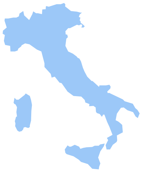
Picture: Geo Map - Europe - Italy
Related Solution:
North Korea, officially the Democratic People's Republic of Korea, is a country in East Asia, in the northern part of the Korean Peninsula.
The vector stencils library North Korea contains contours for ConceptDraw DIAGRAM diagramming and vector drawing software. This library is contained in the Continent Maps solution from Maps area of ConceptDraw Solution Park.
Picture: Geo Map - Asia - North Korea
Related Solution:
Jamaica is an island country situated in the Caribbean Sea, comprising the third-largest island of the Greater Antilles.
The vector stencils library Jamaica contains contours for ConceptDraw DIAGRAM diagramming and vector drawing software. This library is contained in the Continent Maps solution from Maps area of ConceptDraw Solution Park.
Picture: Geo Map - South America - Jamaica
Related Solution:
Nebraska is a state on the Great Plains of the Midwestern United States.
The vector stencils library Nebraska contains contours for ConceptDraw DIAGRAM diagramming and vector drawing software. This library is contained in the Continent Maps solution from Maps area of ConceptDraw Solution Park.
Picture: Geo Map — USA — Nebraska
Related Solution:
Papua New Guinea, officially named the Independent State of Papua New Guinea, is a country in Oceania that occupies the eastern half of the island of New Guinea (the western portion of the island is a part of the Indonesian provinces of Papua and West Papua) and numerous offshore islands.
The vector stencils library Papua New Guinea contains contours for ConceptDraw DIAGRAM diagramming and vector drawing software. This library is contained in the Continent Maps solution from Maps area of ConceptDraw Solution Park.
Picture: Geo Map - Asia - Papua New Guinea
Related Solution:
Create value stream maps - for value stream analysis and value stream management, material and information flow mapping, using our quick start templates included with ConceptDraw.
Picture: Best Value Stream Mapping mac Software
Related Solution:


