Map of Continents
A very large landmass on the planet we are living on is known to be a “continent”. The largest of them is, obviously, Asia, the second largest is Africa, followed by North and South America, Antarctica and Europe. The smallest continent of the Earth is Australia which is basically a large island country, including also some other small islands. Talking about the islands, they are grouped with a neighbouring continent in order to divide all of the world's land into the separate geopolitical regions. Most of the existing territories as well as island countries in the Ocean (Pacific one) are all grouped together with main smallest continent (Australia) forming a separate geopolitical region (Oceania).
Everyone being asked, imagines continents to be large, discrete and continuous masses of land, usually separated by the expanses of water of the oceans. Although, a few of them are not discrete landmasses completely separated by the water. To compare: Greenland has its surface area of 2166086 square kilometres equalling 836330 square miles being on the top of the world's largest islands; at the same time, Australia has 7617930 square kilometres of its surface area equalling 2941300 square miles and it is known as the smallest continent in the world, on our planet.
The well-known term of the “continental Europe” can be used for referring to mainland Europe: all of the other countries, but islands, such as Malta, Ireland, Iceland and the United Kingdom of the Great Britain. The “continent of Australia” may be also called “the mainland of Australia”, including all the small islands all around the main large one, but New Guinea and Tasmania. Same, the United States of America are meant to be known as the 48 contiguous states as well as Columbia (the District of Columbia), situated in the central North America. Although the last term may also include Alaska, but not Guam, Puerto Rico or Hawaii.
Again, the term “continent” may be interpreted as a “dry land, including the shallow, islands and the so-called “submerged adjacent area” known also as simply the “continental shelf”, which is an underwater landmass, extended from a continent itself, which results in an area of relatively shallow water - shelf sea. Thus, the “continental shelf” is the true edge of the continent, so, for example, the islands of the United Kingdom of Great Britain as well as all of the territory of Ireland as a separate country are part of Europe, but at the same time the island of New Guinea and Australia are one continent.
Nowadays only two continents, which are Australia and Antarctica, are completely separated from the other continents (by ocean). There are also a few more continents, which are defined as not absolutely distinct territories, but as so-called “discrete masses of land". Thus, Africa and Asia are joined by the Isthmus of Suez, South and North America - by the Isthmus of Panama. But, there is still no complete separation of these landmasses by water, as the mentioned canals are too narrow and shallow, furthermore - artificial. Both of the isthmuses are very narrow, so there is no need of treating the mentioned continents very distant from each other.
North and South America are also treated as separate continents among all of the seven continents on the Earth. But at the same time, they can be easily treated as a single continent, known as “America”, which was common in the United States of America until the World War II. Talking about another two continents, which are South Asia and Europe - they are peninsulas of the Eurasian landmass. Although, Europe is known as a continent with its quite large land area of 10180000 square kilometres, which equals to 3930000 square miles. But South Asia, being less than half of that area, is considered as a “subcontinent”. Such term as “Eurasia” is treated as a single continent resulting in a six-continent view of the whole world. Some people may say that Asia, Europe and Africa form a single continent, referred to so-called “Afro-Eurasia”, producing the four-continent model of America, Antarctica, Australia and the mentioned above Afro-Eurasia.
A long time before there were just three discrete continents, which were Afro-Eurasia-America, Australia-New Guinea and Antarctica. The “seven-continent model” is taught in schools in India, the Philippines, China, Pakistan, the United Kingdom and most of the English-speaking countries, including those of Western Union. At the same time, the “six-continent model” with “combined-Eurasia” is used in Japan, Russia and some of the European countries – mainly, its eastern part. There is another “six-continent model”, which includes the “combined-America” term. This last model is widely used in Italy and Portugal, Romania and Spain, Greece, France and Latin America. The very last know model is a “five-continent” one, which is obtained by excluding “Antarctica” for a reason of it to be uninhabited.
The commonly used term “Oceania” can refer to a group of the territories in the Pacific Ocean, including the continent (which is also known to be a large country) — Australia. The islands in the Pacific Ocean, including Hawaii, Japan as well as Easter Island are grouped with those continents more than with Oceania, as this term is used in only a few different continental models instead of “Australia”.
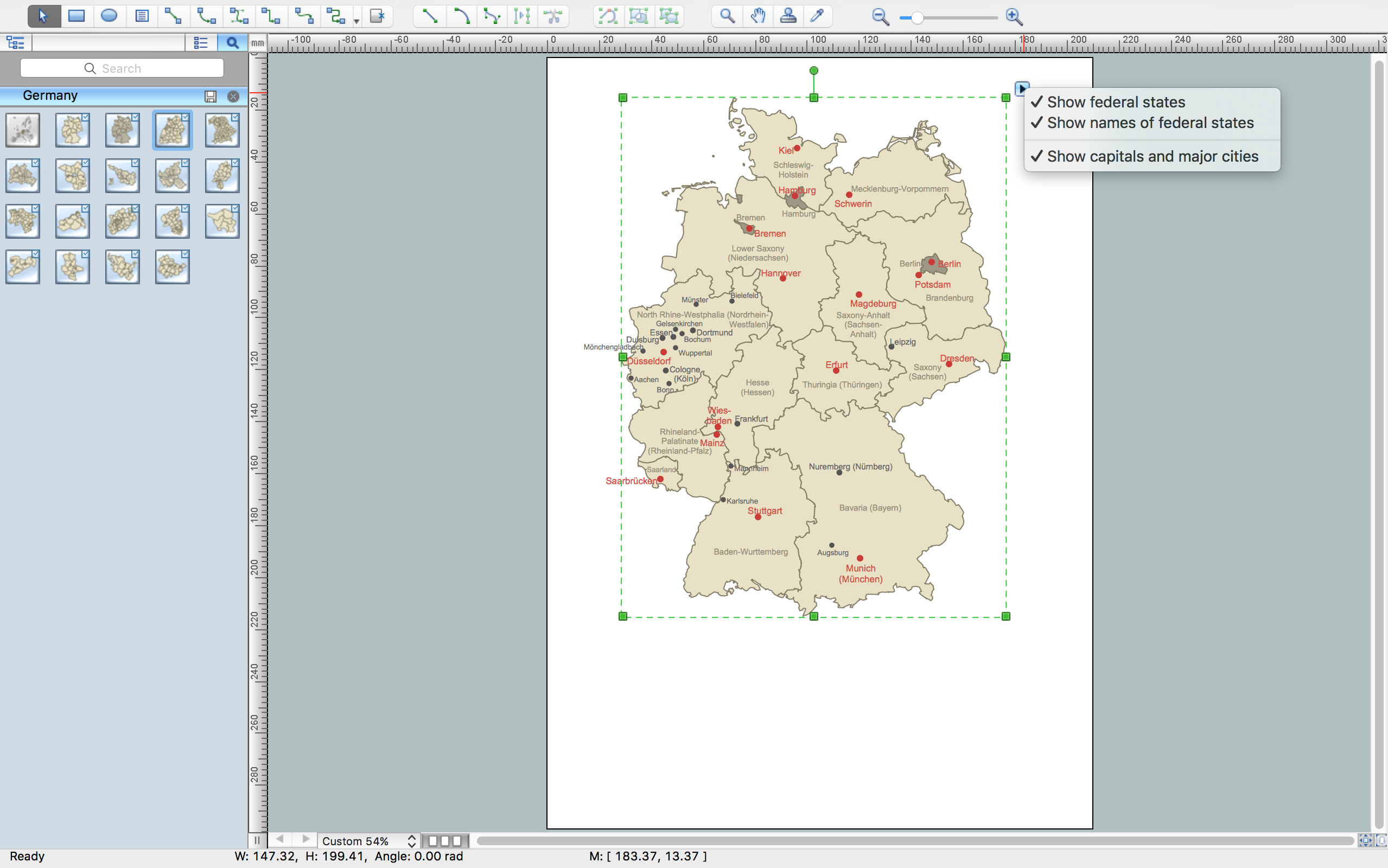
Nevertheless, knowing what you want to draw and whether you are ready to create a map of all of the continents the way you want them to look like, or you want to stick to the already world-widely accepted template, you can make your own map of the continents, so it will look the way you want it to be. Having ConceptDraw DIAGRAM diagramming and vector drawing software as well as the unique “Continent Maps Solution” from the “Maps Area” from this site or from ConceptDraw STORE, allows you to make such things happen. As once you have all of the necessary tools, it is never a problem to make something very special, which can be used for developing your business: for using in your presentations, etc.


Example 1. Map of Continents — South America Map
It is impossible to imagine geography, politics, economics, and many other fields of science without maps. Continent Maps Solution with its collection of samples, templates and libraries is the best for drawing the map of continents.


13 libraries of the Continent Maps Solution contain all needed vector shapes for creating map of continents, geographical maps, thematic maps, cartograms for various geographic areas, etc.

Example 2. Map of Continents — Central Asia Political Map
The samples you see on this page were created in ConceptDraw DIAGRAM software using the Continent Maps solution. Each map of continents created in ConceptDraw DIAGRAM successfully demonstrates solution's capabilities and professional results you can achieve. An experienced user spent 5-10 minutes creating each of these samples.
Use the Continent Maps solution for ConceptDraw DIAGRAM software to create your own continent maps and map of continents of any complexity quick, easy and effective.
All source documents are vector graphic documents. They are available for reviewing, modifying, or converting to a variety of formats (PDF file, MS PowerPoint, MS Visio, and many other graphic formats) from the ConceptDraw STORE. The Continent Maps Solution is available for all ConceptDraw DIAGRAM or later users.