Geo Map — USA — Massachusetts
Maps of USA — Commonwealth of Massachusetts
"Massachusetts, officially the Commonwealth of Massachusetts, is a state in the New England region of the northeastern United States. It is bordered by Rhode Island and Connecticut to the south, New York to the west, and Vermont and New Hampshire to the north; at its east lies the Atlantic Ocean. Massachusetts is the 7th smallest, but the 14th most populous and the 3rd most densely populated of the 50 United States. Massachusetts features two separate metropolitan areas: Greater Boston in the east and the Springfield metropolitan area in the west. Approximately two-thirds of Massachusetts' population lives in Greater Boston. Generally the Greater Boston boundary is regarded as the Atlantic Ocean to the east and areas just north, west, and south of Interstate 495 to the west, north, and south. Western Massachusetts features one urban area - the Knowledge Corridor along the Connecticut River - and a mix of college towns and rural areas. Many of Massachusetts' towns, cities, and counties have names identical to ones in England. Massachusetts is the most populous of the six New England states and has the nation's sixth highest GDP per capita." [Massachusetts. Wikipedia]
The vector stencils library Massachusetts contains contours for ConceptDraw DIAGRAM diagramming and vector drawing software. This library is contained in the Continent Maps solution from Maps area of ConceptDraw Solution Park.

Pic. 1. Continent Maps Solution
Use the Massachusetts library to draw thematic maps, geospatial infographics and vector illustrations for your business documents, presentations and websites.
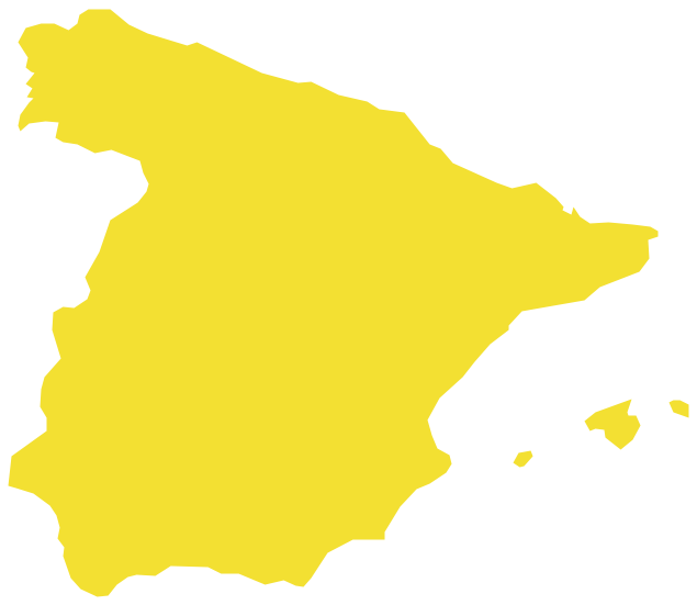
Geo Map — USA — Commonwealth of Massachusetts
Area 10,565 sq mi (27,336 km2); Width 183 miles (295 km); Length 113 miles (182 km).

Pic. 2. Commonwealth of Massachusetts
Geo Map — USA — Massachusetts Contour
Capital — Boston.

Pic. 3. USA — Massachusetts Contour
Geo Map — USA
The United States of America, is a federal republic composed of 50 states, a federal district, five major territories.

Pic. 4. USA Map
Geo Map — USA Contour
A contour map is a map illustrated with contour lines.

Pic. 5. USA Contour
Geo Map — Contours of Territories of the United States
Use the map contours library "United States of America" to design thematic maps using the ConceptDraw DIAGRAM diagramming and vector drawing software.
The vector stencils library "United States of America" contains 53 map contours: US political map, map contours of states.

Pic. 6. Contours of Territories of the United States
All ConceptDraw DIAGRAM documents are vector graphic files and are available for reviewing, modifying, and converting to a variety of formats: image, HTML, PDF file, MS PowerPoint Presentation, Adobe Flash, MS Visio (.VDX, .VSDX).
See Also Territories of the United States Geo Maps :
- Alabama
- Alaska
- Arizona
- Arkansas
- California
- Colorado
- Connecticut
- Delaware
- Florida
- Georgia
- Hawaii
- Idaho
- Illinois
- Indiana
- Iowa
- Kansas
- Kentucky
- Louisiana
- Maine
- Maryland
- Massachusetts
- Mexico
- Michigan
- Minnesota
- Mississippi
- Missouri
- Montana
- Nebraska
- Nevada
- New Hampshire
- New Jersey
- New Mexico
- New York
- North Carolina
- North Dakota
- Ohio
- Oklahoma
- Oregon
- Pennsylvania
- Tennesse
- Utah
- Vermont
- Virginia
- Washington
- West Virginia
- Wisconsin
- Wyoming
- United States