Geo Map — USA — Georgia
Maps of USA — State of Georgia
"Georgia is a state located in the southeastern United States. It was established in 1732, the last of the original Thirteen Colonies. Named after King George II of Great Britain, Georgia was the fourth state to ratify the United States Constitution, on January 2, 1788. It declared its secession from the Union on January 19, 1861, and was one of the original seven Confederate states. It was the last state to be restored to the Union, on July 15, 1870. Georgia is the 24th most extensive and the 8th most populous of the 50 United States. From 2007 to 2008, 14 of Georgia's counties ranked among the nation's 100 fastest-growing, second only to Texas. Georgia is known as the Peach State and the Empire State of the South. Atlanta is the state's capital and its most populous city."
[Georgia (U.S. state). Wikipedia]
The vector stencils library Georgia contains contours for ConceptDraw DIAGRAM diagramming and vector drawing software. This library is contained in the Continent Maps solution from Maps area of ConceptDraw Solution Park.
Use the Georgia library to draw thematic maps, geospatial infographics and vector illustrations for your business documents, presentations and websites.
Geo Map — USA — State of Georgia

Geo Map — USA — Georgia Contour

Geo Map — USA

Geo Map — USA Contour

Geo Map — Contours of Territories of the United States

See Also Territories of the United States Geo Maps :
EIGHT RELATED HOW TO's:
Pie Graph is very popular kind of charts which is widely used in various fields of science and life activities. ConceptDraw DIAGRAM extended with Pie Charts Solution from the Graphs and Charts area is the best software for drawing the Pie Graph Worksheets.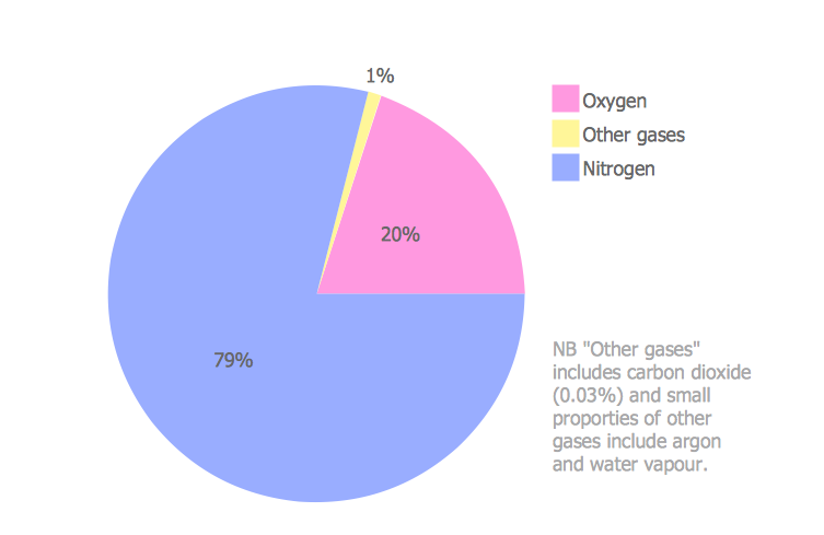
Picture: Pie Graph Worksheets
Related Solution:
Lebanon, officially the Lebanese Republic, is a Democratic Republic country in the East Mediterranean.
The vector stencils library Lebanon contains contours for ConceptDraw DIAGRAM diagramming and vector drawing software. This library is contained in the Continent Maps solution from Maps area of ConceptDraw Solution Park.
Picture: Geo Map - Asia - Lebanon
Related Solution:
Haiti, officially the Republic of Haiti, is a Caribbean country.
The vector stencils library Haiti contains contours for ConceptDraw DIAGRAM diagramming and vector drawing software. This library is contained in the Continent Maps solution from Maps area of ConceptDraw Solution Park.
Picture: Geo Map - South America - Haiti
Related Solution:
India, officially the Republic of India (Bharat Ganrajya), is a country in South Asia.
The vector stencils library India contains contours for ConceptDraw DIAGRAM diagramming and vector drawing software. This library is contained in the Continent Maps solution from Maps area of ConceptDraw Solution Park.
Picture: Geo Map - Asia - India
Related Solution:
Idaho is a state in the northwestern region of the United States.
The vector stencils library Idaho contains contours for ConceptDraw DIAGRAM diagramming and vector drawing software. This library is contained in the Continent Maps solution from Maps area of ConceptDraw Solution Park.
Picture: Geo Map — USA - Idaho
Related Solution:
Indiana is a U.S. state located in the midwestern and Great Lakes regions of North America.
The vector stencils library Indiana contains contours for ConceptDraw DIAGRAM diagramming and vector drawing software. This library is contained in the Continent Maps solution from Maps area of ConceptDraw Solution Park.
Picture: Geo Map — USA — Indiana
Related Solution:
Florida is a state in the southeastern region of the United States, bordered to the west by the Gulf of Mexico, to the north by Alabama and Georgia, to the east by the Atlantic Ocean, and to the south by the Straits of Florida.
The vector stencils library Florida contains contours for ConceptDraw DIAGRAM diagramming and vector drawing software. This library is contained in the Continent Maps solution from Maps area of ConceptDraw Solution Park.
Picture: Geo Map — USA — Florida
Related Solution:
Alabama is a state located in the southeastern region of the United States.
The vector stencils library Alabama contains contours for ConceptDraw DIAGRAM diagramming and vector drawing software. This library is contained in the Continent Maps solution from Maps area of ConceptDraw Solution Park.
Picture: Geo Map — USA — Alabama
Related Solution:


