Geo Map - Australia - New South Wales

Geo Map - Australia - New Zealand

Geo Map - Australia

Geo Map - Australia - Victoria

Geo Map - Australia - Nothern Territory

Geo Map - Australia - Queensland

Geo Map - Australia - Western Australia

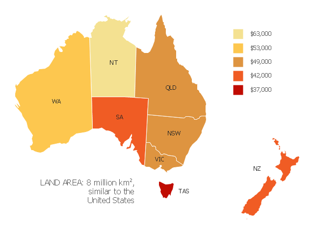
"Household income is a measure of the combined incomes of all people sharing a particular household or place of residence. It includes every form of income, e.g., salaries and wages, retirement income, near cash government transfers like food stamps, and investment gains.
Average household income can be used as an indicator for the monetary well-being of a country's citizens. Mean or median net household income, after taxes and mandatory contributions, are good indicators of standard of living, because they include only disposable income and acknowledge people sharing accommodation benefit from pooling at least some of their living costs.
Average household incomes need not map directly to measures of an individual's earnings such as per capita income as numbers of people sharing households and numbers of income earners per household can vary significantly between regions and over time." [Household income. Wikipedia]
This map example shows 2007 median household incomes in the states and mainland territories of the Commonwealth of Australia.
The thematic map example "Map of median household income in Australia" was redesigned from the Wikimedia Commons file: Map of median household income in Australia.PNG.
[commons.wikimedia.org/ wiki/ File:Map_ of_ median_ household_ income_ in_ Australia.PNG]
The example "Map of median household income in Australia" was created using the ConceptDraw PRO diagramming and vector drawing software extended with the Continent Map solution from the Maps area of ConceptDraw Solution Park.
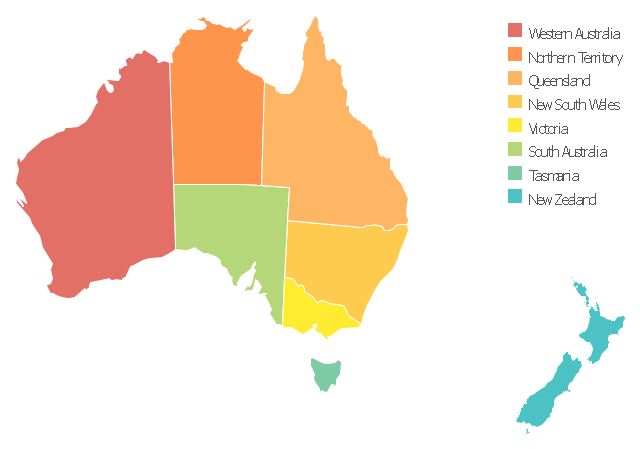
Thematic map - Australia
Use this template to design your Australia political map, cartogram or thematic map, to visualize your spatial business information connected with geographic areas, locations or ways.
This Australia map template for the ConceptDraw PRO diagramming and vector drawing software is included in the Continent Maps solution from the Maps area of ConceptDraw Solution Park.
This Australia map template for the ConceptDraw PRO diagramming and vector drawing software is included in the Continent Maps solution from the Maps area of ConceptDraw Solution Park.
Australia thematic map template
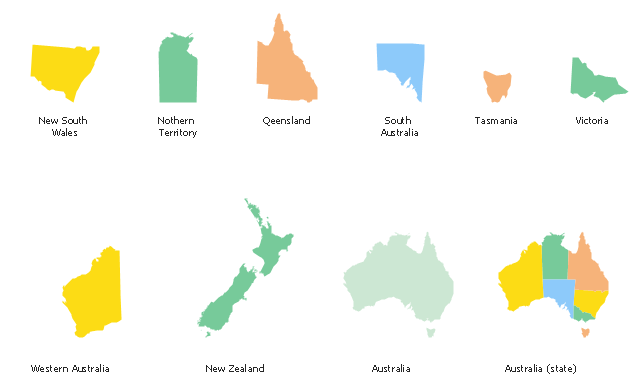
Use the map contours library "Australia" to design thematic maps using the ConceptDraw PRO diagramming and vector drawing software.
The vector stencils library "Australia" contains 10 map contours: Australia continent contour, Australia political maps, map contours of New Zealand and Australian states and mainland territories: New South Wales, Nothern Territory, Qeensland, Tasmania, Victoria, Western Australia.
The map contours example "Design elements - Australia" is included in the Continent Maps solution from the Maps area of ConceptDraw Solution Park.
Australia and New Zealand map contours
"Alpine skiing is the sport of sliding down snow-covered hills on skis with fixed-heel bindings. It is also commonly known as downhill skiing, although that also incorporates different styles. Alpine skiing can be contrasted with skiing using free-heel bindings; ski mountaineering and nordic skiing – such as cross-country; ski jumping; and Telemark. Alpine skiing is popular wherever the combination of snow, mountain slopes, and a sufficient tourist infrastructure can be built up, including parts of Europe, North America, Australia and New Zealand, the South American Andes, and East Asia.
Alpine skiing began as a club sport 1861 at Kiandra in Australia and a number of similar clubs in North America and the Austrian and Swiss Alps. Today, most alpine skiing occurs at a ski resort with ski lifts that transport skiers up the mountain. The snow is groomed, avalanches are controlled and trees are cut to create trails. Many resorts also include snow making equipment to provide skiing when the weather would otherwise not allow it. Alternatively, alpine skiers may pursue the sport in less controlled environments; this practice is variously referred to as ski touring, backcountry skiing, or extreme skiing.
In competitive alpine skiing races four disciplines exist: slalom, giant slalom, super giant slalom, and downhill. Slalom ski races have courses that require short tight turns, whereas giant-slalom races have courses which are set with more widely spaced turns. Super-giant slalom and downhill have few turns, the courses have gates spaced widely apart and skiers often reach 100 km/ h." [Alpine skiing. Wikipedia]
The vector icon example "Alpine skiing" represents one of 20 symbols from the Winter sports pictograms library for the ConceptDraw PRO diagramming and vector drawing software.
The design elements library Winter sports pictograms is included in the Winter Sports solution from the Sport area of ConceptDraw Solution Park.
Alpine skiing

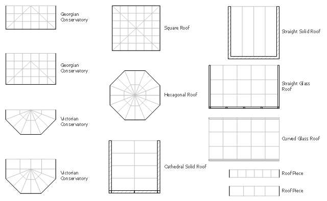
The design elements library Sunrooms contains 12 symbols of glass roof and conservatory.
Use the vector stencils library Sunrooms to draw the sunroom design plans, home layouts, architectural and construction documents.
"A sunroom, sun parlor, sun porch, or sun lounge is a structure usually constructed onto the side of a house which allows enjoyment of the surrounding landscape while being sheltered from adverse weather conditions such as rain and wind. It can be referred to as a patio room, solarium, conservatory or Florida room. The concept is popular in the United States, Europe, Canada, Australia, and New Zealand.
In Great Britain, the term conservatory is usually used to refer to a sunroom despite not being used as a greenhouse as traditional conservatories were. However, sunrooms with opaque roofs may be considered distinct from conservatories with transparent or semi-transparent roofs." [Sunroom. Wikipedia]
The shapes library Sunrooms is provided by the Floor Plans solution from the Building Plans area of ConceptDraw Solution Park.
Sunroom symbols
Geo Map - Europe - Germany

Use the map contours library "Australia" to design thematic maps using the ConceptDraw PRO diagramming and vector drawing software.
The vector stencils library "Australia" contains 10 map contours: Australia continent contour, Australia political maps, map contours of New Zealand and Australian states and mainland territories: New South Wales, Nothern Territory, Qeensland, Tasmania, Victoria, Western Australia.
The map contours example "Design elements - Australia" is included in the Continent Maps solution from the Maps area of ConceptDraw Solution Park.
The vector stencils library "Australia" contains 10 map contours: Australia continent contour, Australia political maps, map contours of New Zealand and Australian states and mainland territories: New South Wales, Nothern Territory, Qeensland, Tasmania, Victoria, Western Australia.
The map contours example "Design elements - Australia" is included in the Continent Maps solution from the Maps area of ConceptDraw Solution Park.
Australia and New Zealand map contours
Geo Map - Oceania

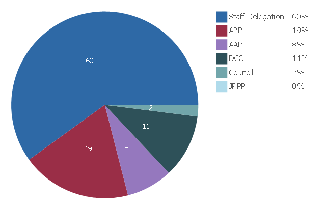
This percentage pie chart example is redesigned from the web page Building and development - How are Development Applications assessed - Determination (approval or rejection) from the Woollahra Municipal Council (New South Wales, Australia) website [www.woollahra.nsw.gov.au/ building_ and_ development/ how_ we_ assess_ your_ da/ determination_ approval_ or_ rejection ].
This file is available under the Creative Commons Attribution-ShareAlike 3.0 Unported License [creativecommons.org/ licenses/ by-sa/ 3.0/ ].
"A pie chart (or a circle graph) is a circular chart divided into sectors, illustrating numerical proportion. In a pie chart, the arc length of each sector (and consequently its central angle and area), is proportional to the quantity it represents. While it is named for its resemblance to a pie which has been sliced, there are variations on the way it can be presented. ...
Pie charts are very widely used in the business world and the mass media." [Pie chart. Wikipedia]
The percentage pie chart example "Development Assessment determination" was created using the ConceptDraw PRO diagramming and vector drawing software extended with the Pie Charts solution of the Graphs and Charts area in ConceptDraw Solution Park.
Percentage pie chart
Geo Map - Canada - New Brunswick

The vector stencils library New Brunswick contains contours for ConceptDraw PRO diagramming and vector drawing software. This library is contained in the Continent Maps solution from Maps area of ConceptDraw Solution Park.
Geo Map - USA - New York

The vector stencils library New York contains contours for ConceptDraw PRO diagramming and vector drawing software. This library is contained in the Continent Maps solution from Maps area of ConceptDraw Solution Park.
Geo Map - USA - New Jersey

The vector stencils library New Jersey contains contours for ConceptDraw PRO diagramming and vector drawing software. This library is contained in the Continent Maps solution from Maps area of ConceptDraw Solution Park.
- Geo Map - Australia - New Zealand
- Geo Map - Australia | Geo Map - Australia - New Zealand | Geo Map ...
- EU 28: Candidate countries map | Geo Map - Australia - New ...
- Geo Map - Australia
- Geo Map - Australia - New Zealand - Conceptdraw.com
- Geo Map - Australia | Geo Map - Australia - New ... - Conceptdraw.com
- Geo Map - Australia - New South Wales - Conceptdraw.com
- Illustration | Geo Map - Australia - New South Wales | Geo Map ...
- Australia map template | Geo Map - Australia - New Zealand | Geo ...
- Geo Map - Australia | Continent Maps | Map of median household ...
- Geo Map - Asia - Papua New Guinea | Geo Map - Australia | Geo ...
- Geo Map - Australia | Geo Map - Europe - Russia | Geo Map ...
- Geo Map - Australia
- Geo Map - Australia - Queensland | Design elements - Australia ...
- Maps | Geo Map - Australia | Geo Map - Europe - Germany |
- Map of Australia depicting time zones offsets from UTC by state ...
- Geo Map - Australia - New South Wales |
- Presentation Clipart | Illustration | Winter Sports |
- Infographic design elements, software tools Subway and Metro style ...
- Business Process Mapping How to Map a Work Process | How to ...