Geo Map - Oceania
Oceania and Australia Map
"Oceania also known as Oceanica, is a region centred on the islands of the tropical Pacific Ocean. Opinions of what constitutes Oceania range from its three subregions of Melanesia, Micronesia, and Polynesia to, more broadly, the entire insular region between Asia and the Americas, including Australasia and the Malay Archipelago. The term is often used more specifically to denote a continent comprising Australia and proximate islands or biogeographically as a synonym for either the Australasian ecozone (Wallacea and Australasia) or the Pacific ecozone (Melanesia, Polynesia, and Micronesia apart either from New Zealand or from mainland New Guinea)." [Wikipedia]
The vector stencils library Education Maps contains contours for ConceptDraw DIAGRAM diagramming and vector drawing software. This library is contained in the Education Infographics solution from Business Infographics area of ConceptDraw Solution Park.

Pic. 1. Education Infographics Solution
Geo Map - Oceania and Australia
Total land area: 3,285,048 sq miles (8,508,238 sq km).Total population: 30.4 million.Number of countries: 14.
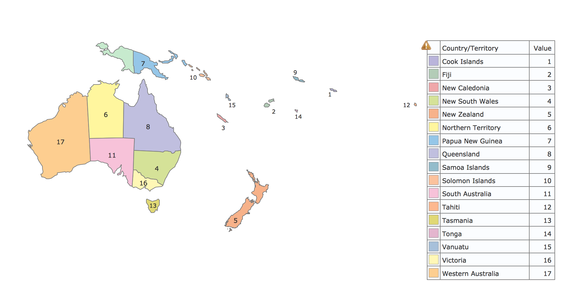
Pic. 2. Oceania and Australia
Geo Map - Oceania Contour
A contour map is a map illustrated with contour lines.

Pic. 2. Oceania Contour
All ConceptDraw DIAGRAM documents are vector graphic files and are available for reviewing, modifying, and converting to a variety of formats: image, HTML, PDF file, MS PowerPoint Presentation, Adobe Flash, MS Visio (.VDX, .VSDX).
TEN RELATED HOW TO's:
Geo Map Software - Full Geographic Reach of Your Business with Geo Map Shapes.
Picture: Geo Map Software
Related Solution:
A flowchart is a powerful tool for examining processes. It helps improving processes a lot, as it becomes much easier to communicate between involved people, to identify potential problems and to optimize workflow. There are flowcharts of different shapes, sizes and types of flowchart vary from quite basic process flowcharts to complex program flowcharts. Nevertheless, all these diagrams use the same set of special symbols like arrows to connect blocks, parallelogram to show data receiving or rectangles for showing process steps.
Basic flowcharts are used to represent a simple process algorithm. A basic flowchart notation consists of rectangles (business processes), arrows (the flow of information, documents, etc.). The same notation is used in items such as the "decision", which allow you to do the branching. To indicate the start of the entire business process and its termination can be used the "Terminator" element. The advantages of Basic Flowchart are simplicity and clarity. With it you can quickly describe the business process steps. Creating of Basic Flowchart does not require any special knowledge, as easily understand by employees with different levels of education and IQ.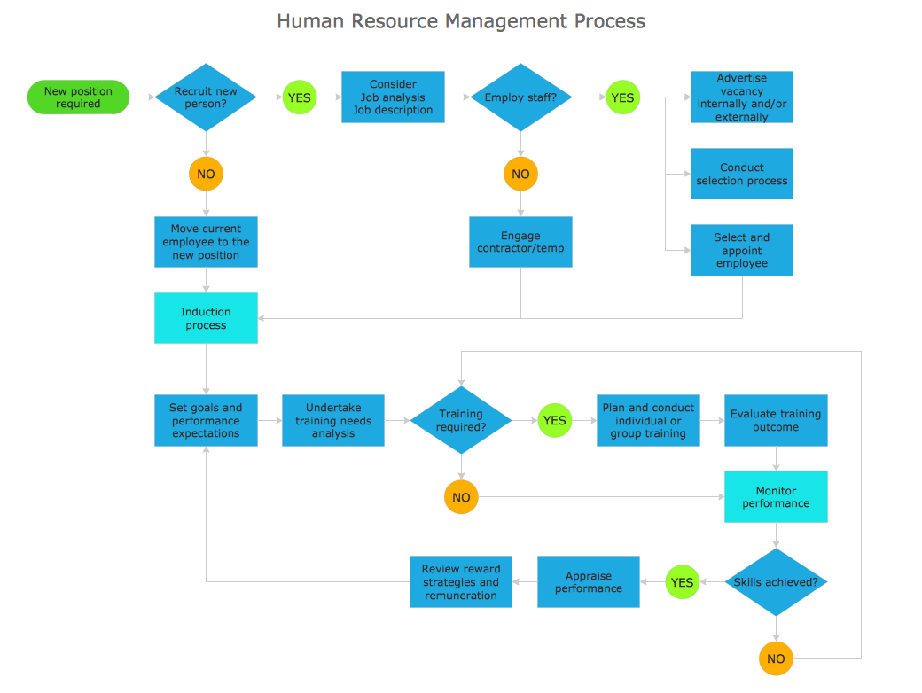
Picture: Types of Flowchart: Comprehensive Overview
Related Solution:
Burma, officially the Republic of the Union of Myanmar, commonly shortened to Myanmar, is a sovereign state in Southeast Asia bordered by Bangladesh, India, China, Laos and Thailand.
The vector stencils library Myanmar contains contours for ConceptDraw DIAGRAM diagramming and vector drawing software. This library is contained in the Continent Maps solution from Maps area of ConceptDraw Solution Park.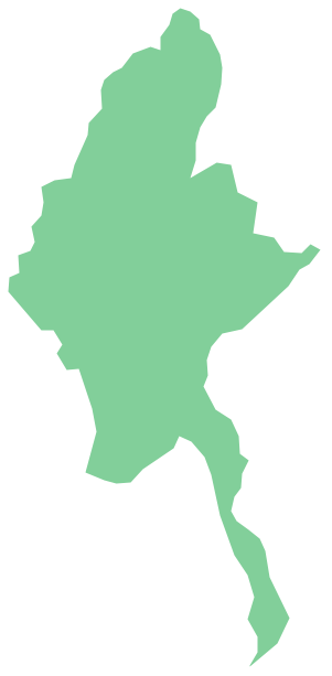
Picture: Geo Map - Asia - Myanmar
Related Solution:
Oman, officially called the Sultanate of Oman, is an Arab state in southwest Asia on the southeast coast of the Arabian Peninsula.
The vector stencils library Oman contains contours for ConceptDraw DIAGRAM diagramming and vector drawing software. This library is contained in the Continent Maps solution from Maps area of ConceptDraw Solution Park.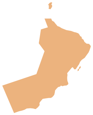
Picture: Geo Map - Asia - Oman
Related Solution:
Connecting objects manually in ConceptDraw DIAGRAM is a snap:
- points;
- Connecting groups of objects;
- Auto-routing;
- Connectors text;
- Snap to Guides ;
- Quick.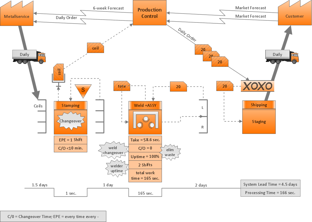
Picture: ConceptDraw Arrows10 Technology
Illustrate the Asia continent and explore its parts, geographical features, resources, and economic development through designing various kinds of colorful Asia maps and using them in presentations, reports, educational materials, websites, business documents
Picture: Geo Map — Asia
Related Solution:
Automatically create a presentation-quality diagram in one click with ConceptDraw DIAGRAM.
Picture: Visual Presentations Made Easy with Diagramming Software
Related Solution:
Designing of Continents Map is a quite complex and labour-intensive process. But now we have a way to make it easier - ConceptDraw DIAGRAM diagramming and vector drawing software extended with useful drawing tools of Continent Maps Solution from the Maps Area.
Picture: Continents Map
Related Solution:
The ConceptDraw vector stencils library Cisco Optical contains symbols for drawing the computer network diagrams.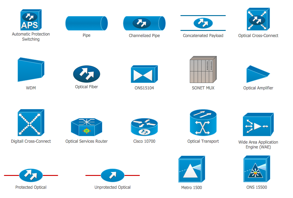
Picture: Cisco Optical. Cisco icons, shapes, stencils and symbols
Related Solution:
To support you in your tasks you can use the power of ConceptDraw DIAGRAM providing intelligent vector graphics that are useful for Business Process diagramming and ConceptDraw MINDMAP for key Business Process mind maps.
Picture: Business Process
Related Solution:
