Geo Map — Australia — New Zealand
New Zealand Map Contours and Geographic Overview
New Zealand is an island country in the Pacific Ocean made up of two main islands — the North Island and the South Island — as well as hundreds of smaller surrounding islands.
Located about 1,500 kilometers east of Australia and roughly 1,000 kilometers from New Caledonia and Fiji, New Zealand is one of the world’s most remote countries. Its isolated location and distinctive natural setting make it especially interesting for geographic visualization and map design.
Key Facts for New Zealand Political and Thematic Maps
The capital of New Zealand is Wellington, while Auckland is the country’s most populous city.
New Zealand extends more than 1,600 kilometers in length and is about 400 kilometers wide at its broadest point. Its total area is approximately 268,000 square kilometers, which makes it one of the world’s largest islands.
These geographic characteristics are important when creating political maps, thematic maps, and other New Zealand map illustrations.
New Zealand Relief Features for Map Illustration
New Zealand is well known for its varied relief and mountainous terrain. The Southern Alps extend along much of the South Island and include 18 peaks higher than 3,000 meters.
The highest mountain is Aoraki / Mount Cook at 3,754 meters. On the North Island, the highest mountain is Mount Ruapehu at 2,797 meters.
These major landforms can be useful reference points when designing geographic diagrams, regional maps, and educational map graphics.
New Zealand in Oceania and Australasia Maps
New Zealand is part of Australasia and is often included in Oceania regional maps together with Australia and Pacific island territories.
It forms the southwestern extremity of Polynesia and is frequently represented in regional map sets covering Oceania, Australasia, and the Pacific region.
Australia Map Contours and Country Overview
Australia includes the mainland continent, Tasmania, and many smaller surrounding islands. It is the sixth-largest country in the world by total area.
Nearby countries and territories include Indonesia, Papua New Guinea, East Timor, Solomon Islands, Vanuatu, and New Zealand. The capital of Australia is Canberra, while Sydney is its most populous city.
Because of its size and administrative divisions, Australia is commonly represented in political maps, state maps, and regional map contour collections.
Australia Political Map and Regional Context
Australia plays an important role in the Oceania region and is often shown together with neighboring countries in geographic maps and regional business presentations.
Its national and state-level divisions make Australia especially suitable for political map visualization, regional planning graphics, and territorial infographics.
Why Use Custom Australia and New Zealand Maps
Custom maps are useful for presentations, business documents, educational materials, and regional planning. They help present geographic information clearly and allow you to focus on the exact territories, states, or islands relevant to your project.
Although many ready-made maps are available online, creating your own Australia and New Zealand maps gives you more control over style, content, and visual emphasis.
Software for Drawing Australia and New Zealand Map Contours
ConceptDraw DIAGRAM provides the tools needed to create professional-looking maps, diagrams, and visual documents. With the right set of vector elements, it becomes much easier to build accurate country maps and customized geographic illustrations.
This is especially useful when you need editable map contours for Australia, New Zealand, and nearby island territories.
Australia Library with New Zealand and State Map Contours
The vector design library called “Australia” includes contours of New Zealand, Australian states, and mainland territories for use in ConceptDraw DIAGRAM.
These ready-made vector elements can help users build political maps, thematic maps, geospatial infographics, and map-based business visuals without drawing every shape manually.
Where to Find Australia and New Zealand Map Templates
The “Australia” library is available in the Continent Maps solution from the Maps area of ConceptDraw Solution Park. It can also be downloaded through ConceptDraw STORE.
Using these solutions gives access to prebuilt map templates and vector stencils that simplify the process of creating country maps and regional illustrations.
Create Thematic Maps and Geospatial Infographics
After downloading ConceptDraw DIAGRAM and the required solution, you can use the “Australia” library to create thematic maps of Australia, New Zealand, and nearby islands.
The library supports the creation of geospatial infographics, political maps, vector illustrations, business documents, presentations, and website graphics. It includes 10 map contours, including an Australia political map and state-level map outlines.

Pic. 1. Continent Maps Solution
Use the Australia library to draw thematic maps, geospatial infographics and vector illustrations for your business documents, presentations and websites.
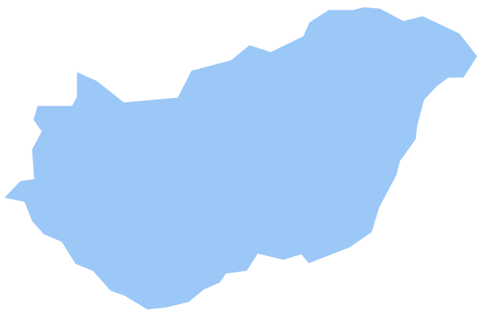
Geo Map — New Zealand
New Zealand has a population of over 4,5 million and an area 268,021 km2(103,483 sq mi).

Pic. 2. New Zealand
Geo Map — New Zealand Contour
Capital - Wellington.
Maps and flowcharts solve different visual tasks. Geographic maps show locations and regions, while flowchart symbols represent steps, decisions, and workflows in business and technical systems.
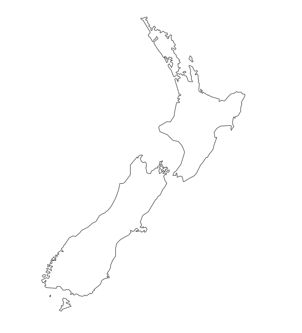
Pic. 3. New Zealand Contour
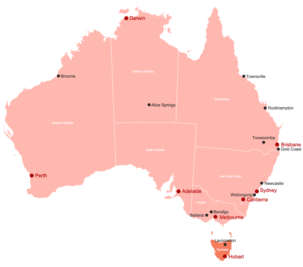
Geo Map — Australia and New Zealand
Australia has six states — New South Wales, Queensland, South Australia, Tasmania, Victoria, Western Australia and two major mainland territories — the Australian Capital Territory and the Northern Territory.
Australia has a population of over 24 million and an area 7,692,024 km2(2,969,907 sq mi).

Pic. 4. Australia and New Zealand map
Geo Map — Australia and New Zealand Contour
A contour map is a map illustrated with contour lines.
In addition to geographic visualization, ConceptDraw solutions support process modeling, including flowcharts, workflow diagrams, and business process mapping for professional documentation.
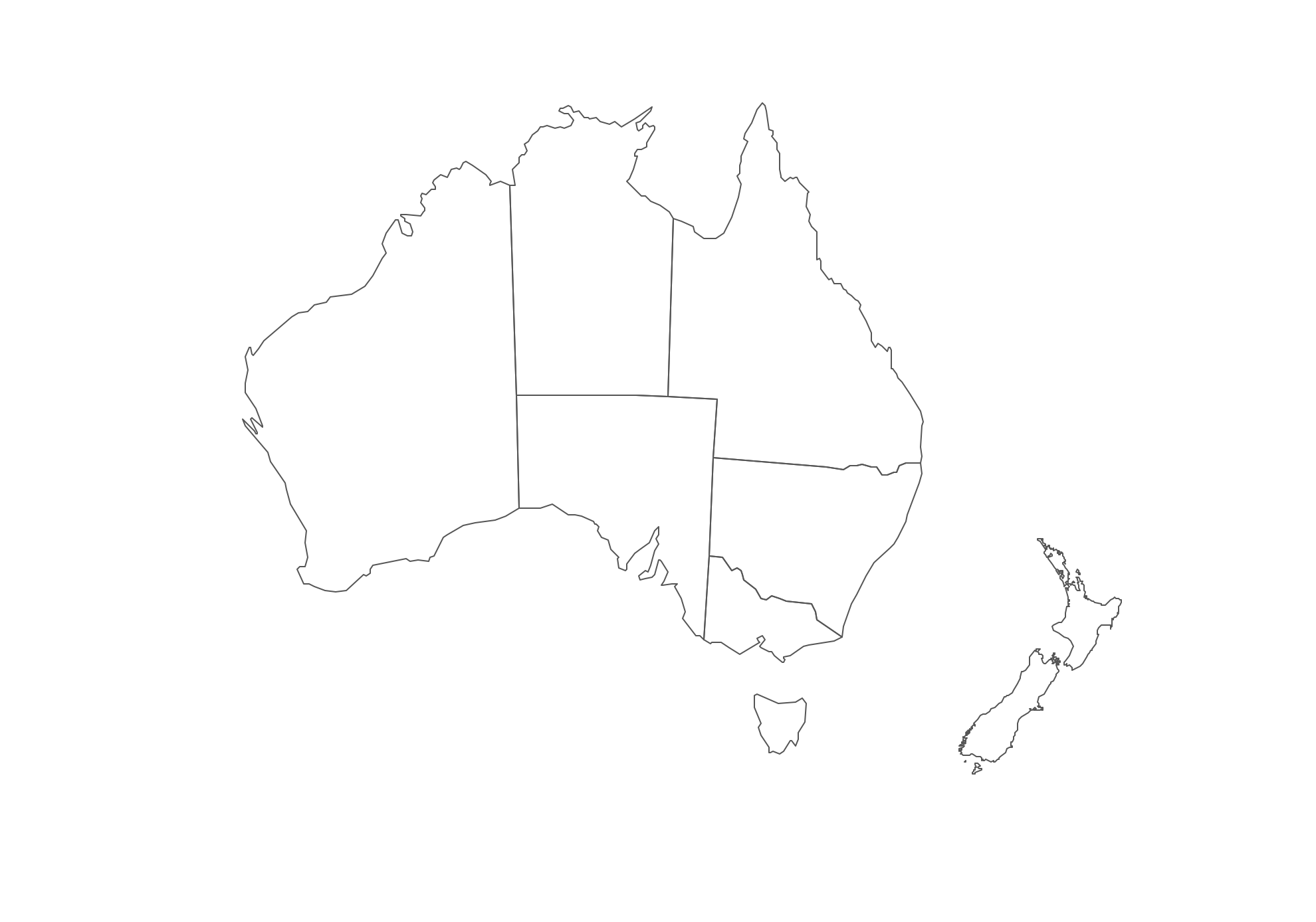
Pic. 5. Australia and New Zealand Contour
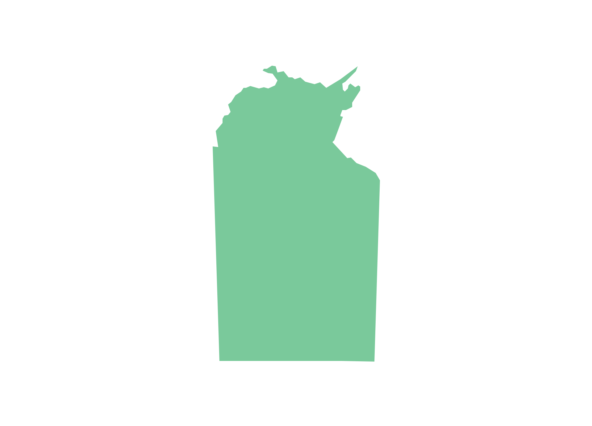
Geo Map — contours of Australian states and mainland territories and New Zealand
Use the map contours library "Australia" to design thematic maps using the ConceptDraw DIAGRAM diagramming and vector drawing software.
The vector stencils library "Australia" contains 10 map contours: Australia political map, map contours of states.
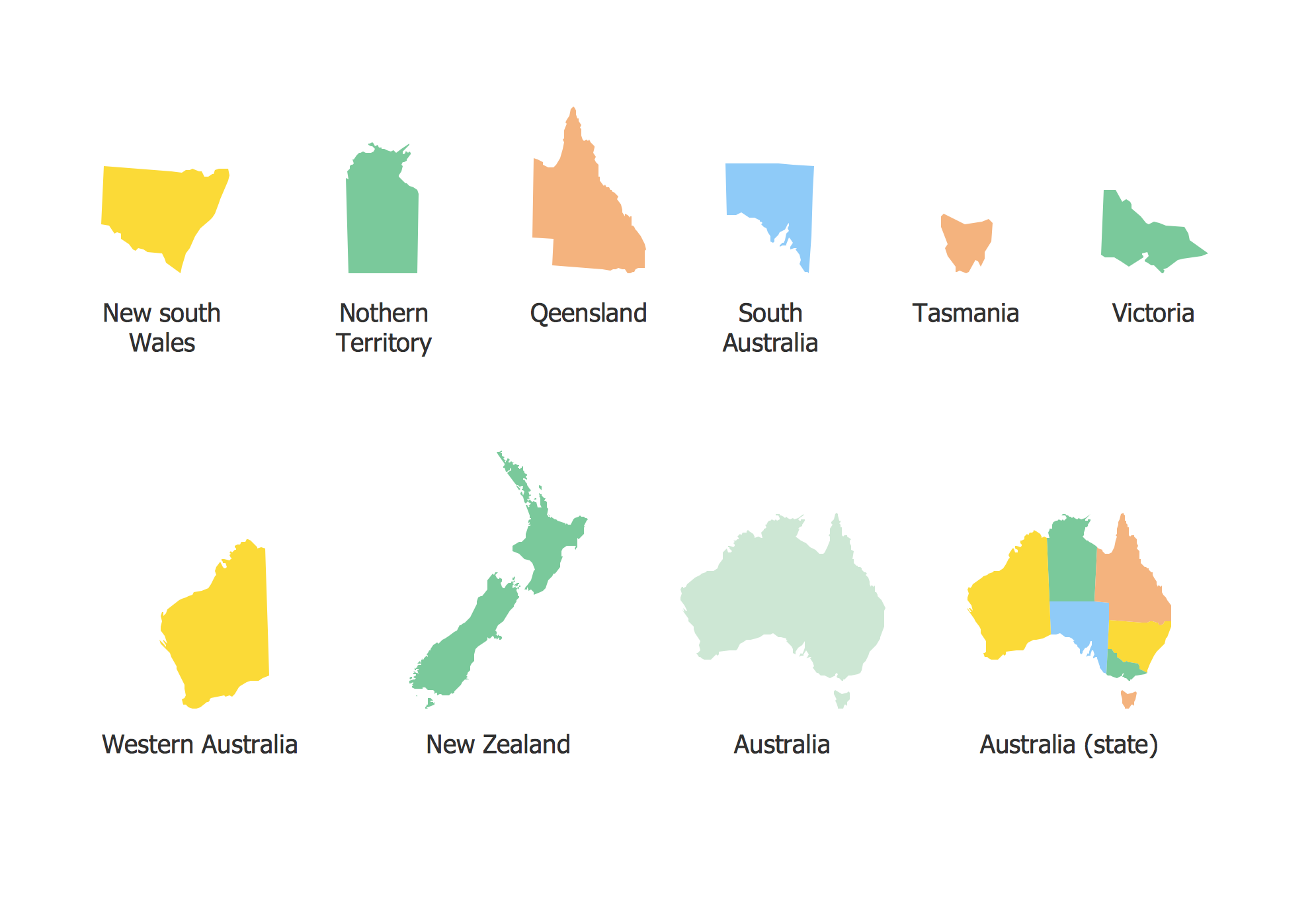
Pic. 6. Contours of Australian states and mainland territories and New Zealand
All ConceptDraw DIAGRAM documents are vector graphic files and are available for reviewing, modifying, and converting to a variety of formats: image, HTML, PDF file, MS PowerPoint Presentation, Adobe Flash, MS Visio (.VDX, .VSDX).