Spatial infographics Design Elements: Location Map

The vector stencils library "Landmarks" contains 34 signs and pictograms for drawing road and transit maps.
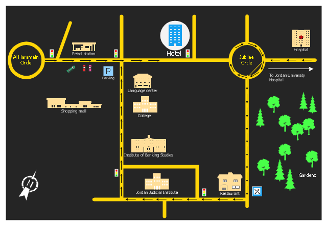
The vector stencils library "Map symbols" contains 10 signs and pictograms for drawing road and transit maps.
"A landmark is a recognizable natural or man-made feature used for navigation, a feature that stands out from its near environment and is often visible from long distances.
In modern use, the term can also be applied to smaller structures or features, that have become local or national symbols." [Landmark. Wikipedia]
The pictograms example "Design elements - Location map" was created using the ConceptDraw PRO diagramming and vector drawing software extended with the Spatial Infographics solution from the Maps area of ConceptDraw Solution Park.
Landmarks and Map symbols

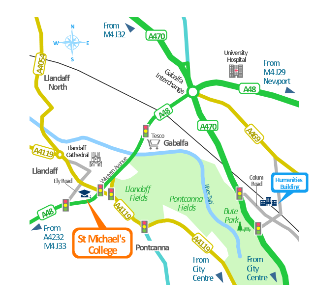
This spatial infographics was created on the bese of the conference centre location map from the website. [cf.ac.uk/ share/ research/ centres/ clarc/ newsandevents/ isns-conference-2013-booking-information.html]
"The terms location and place in geography are used to identify a point or an area on the Earth's surface or elsewhere. The term location generally implies a higher degree of certainty than place, which often indicates an entity with an ambiguous boundary, relying more on human/ social attributes of place identity and sense of place than on geometry.
Types of location/ place.
(1) A relative location is described as a displacement from another site...
(2) A locality is likely to have a well-defined name but a boundary which is less well defined and which varies by context." [Location (geography). Wikipedia]
The spatial infographics example "Conference centre location map" was created using the ConceptDraw PRO diagramming and vector drawing software extended with the Spatial Infographics solution from the area "What is Infographics" of ConceptDraw Solution Park.
Spatial infographics
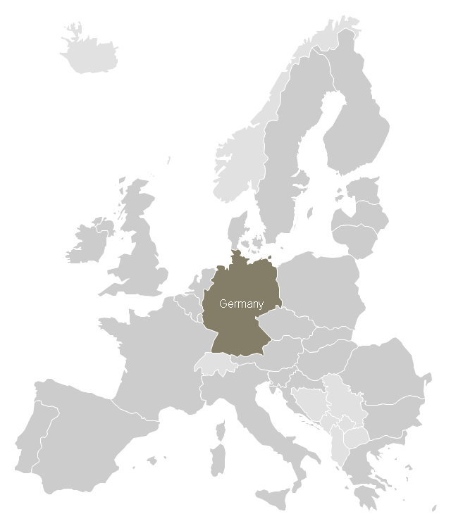
Use this Germany locator map template to design Germany in the European Union political and thematic maps with ConceptDraw PRO software.
The template "Germany location map" is included in the Map of Germany solution from the Maps area of ConceptDraw Solution Park.
The template "Germany location map" is included in the Map of Germany solution from the Maps area of ConceptDraw Solution Park.
Locator map of Germany
Map Infographic Tool

This location map sample was created on the base on the map "Location of the Migration Health Assessment Center (MHAC)" from the website of the U.S. Embassy in Nepal. "Applicants for U.S. immigrant visas and transportation letters are required to have medical examinations performed by IOM (International Organization for Migration) Embassy panel physicians. ... Health assessments for the immigrants to the US are conducted by the International Organization for Migration (IOM) at the Migration Health Assessment Center."
[nepal.usembassy.gov/ visas/ immigrant-visas/ medical-exams.html]
The location map example "Location of the Migration Health Assessment Center (MHAC)" was created using the ConceptDraw PRO diagramming and vector drawing software extended with the Directional Maps solution from the Maps area of ConceptDraw Solution Park.
Location map
.png--diagram-flowchart-example.png)
Brilliant Examples of Infographics Map, Transport, Road

Spatial infographics Design Elements: Transport Map

Map Infographic Design

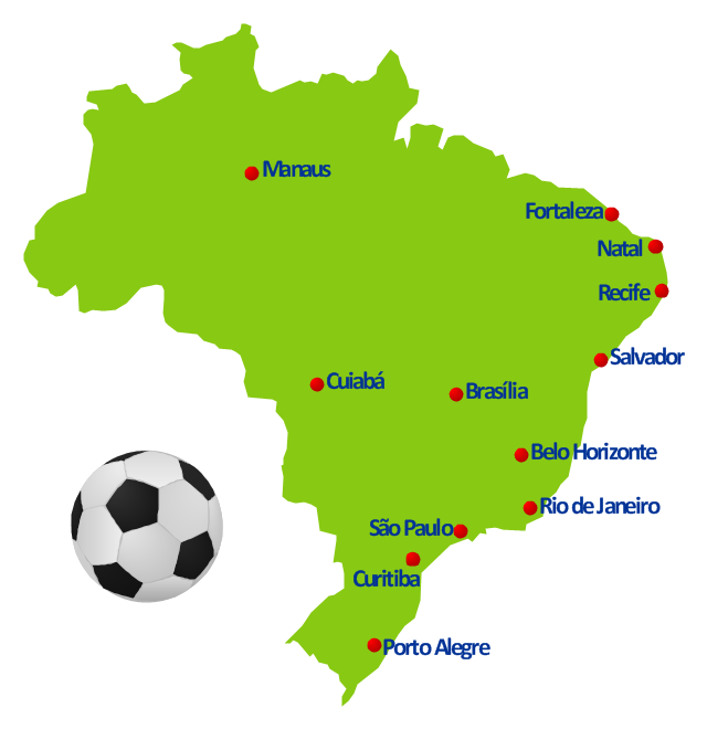
This spatial infographics example was created on the base of Brazil location map from the Wikipedia article "2014 FIFA World Cup". [en.wikipedia.org/ wiki/ 2014_ FIFA_ World_ Cup]
"The 2014 FIFA World Cup will be the 20th FIFA World Cup, an international men's football tournament that is scheduled to take place in Brazil from 12 June to 13 July 2014. ...
Eighteen locations were presented as potential World Cup host cities: Belém, Belo Horizonte, Brasília, Campo Grande, Cuiabá, Curitiba, Florianópolis, Fortaleza, Goiânia, Maceió, Manaus, Natal, Porto Alegre, Recife, Rio Branco, Rio de Janeiro, Salvador and São Paulo." [2014 FIFA World Cup. Wikipedia]
The geospatial infographics example "2014 FIFA World Cup - Brazil location map" was created using the ConceptDraw PRO diagramming and vector drawing software extended with the Soccer solution from the Sport area of ConceptDraw Solution Park.
Geospatial infographics
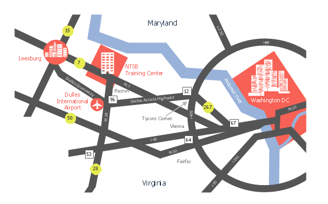
This location map sample was created on the base of the location map from the website of the NTSB Training Center.
"The NTSB Training Center is the training facility for the National Transportation Safety Board, an independent federal agency that investigates all civil aviation accidents in the United States and selected accidents in other modes of transportation.
The Training Center provides training for NTSB investigators and others from the transportation community to improve their practice of accident investigation techniques. The curriculum promotes independent, objective, and technically advanced accident investigations that will enhance the safety of all modes of transportation. ... Located on the Virginia campus of The George Washington University in Ashburn, the Training Center is ten miles from Washington Dulles Airport and 30 miles from Washington, D.C. Driving directions, maps, and a link to the virtual tour of our facility are available on the Campus page." [ntsb.gov/ trainingcenter/ about.htm]
The location map example "NTSB Training Center location" was created using the ConceptDraw PRO diagramming and vector drawing software extended with the Directional Maps solution from the Maps area of ConceptDraw Solution Park.
Location map
How tо Represent Information Graphically

"A locator map, sometimes referred to simply as a locator, is typically a simple map used in cartography to show the location of a particular geographic area within its larger and presumably more familiar context. Depending on the needs of the cartographer, this type of map can be used on its own or as an inset or addition to a larger map. ...
Direct marketing.
The widespread distribution of sophisticated Geographic Information System (GIS) mapping techniques has allowed the development of large-scale customized locator maps that can be tailored to individual consumers in direct marketing campaigns. This sophistication allows a variety of customized locator maps to be produced in a relatively short period of time. Major types of direct marketing locator maps are:
Single Location: A single business location is shown with major street and road connections. While this type of map can be efficiently constructed using GIS with existing street databases and customized map templates, special software is not required because the map does not change for each direct mailing." [Locator map. Wikipedia]
This example was created using the ConceptDraw PRO diagramming and vector drawing software extended with the Directional Maps solution from the Maps area of ConceptDraw Solution Park.
Hotel location map
This location map sample was created on the base on the map "Location of the Migration Health Assessment Center (MHAC)" from the website of the U.S. Embassy in Nepal. "Applicants for U.S. immigrant visas and transportation letters are required to have medical examinations performed by IOM (International Organization for Migration) Embassy panel physicians. ... Health assessments for the immigrants to the US are conducted by the International Organization for Migration (IOM) at the Migration Health Assessment Center."
[nepal.usembassy.gov/ visas/ immigrant-visas/ medical-exams.html]
The location map example "Location of the Migration Health Assessment Center (MHAC)" was created using the ConceptDraw PRO diagramming and vector drawing software extended with the Directional Maps solution from the Maps area of ConceptDraw Solution Park.
[nepal.usembassy.gov/ visas/ immigrant-visas/ medical-exams.html]
The location map example "Location of the Migration Health Assessment Center (MHAC)" was created using the ConceptDraw PRO diagramming and vector drawing software extended with the Directional Maps solution from the Maps area of ConceptDraw Solution Park.
Location map
Spatial infographics Design Elements: Continental Map

- Spatial infographics Design Elements: Location Map | Brilliant ...
- Directional Maps | Directions Maps | Conference centre location ...
- Spatial infographics Design Elements: Location Map | Design ...
- Location Plan And Vicinity Map Sample
- Location of the Migration Health Assessment Center (MHAC ...
- Germany location map - Template | Spatial infographics Design ...
- Map symbols - Vector stencils library | Design elements - Location ...
- Conference centre location map | Directional Maps | 2D Directional ...
- Directions Map | Directions Maps | Maps Driving Directions ...
- Spatial infographics Design Elements: Location Map | Brilliant ...
- Spatial infographics Design Elements: Location Map | Design ...
- Design elements - Location map | Symbol Of Towns In Map Of Nepal
- Design elements - Location map | Road signs - Vector stencils ...
- Spatial infographics Design Elements: Location Map | Process ...
- USA Maps | Design elements - Location map | How To Draw ...
- Design elements - Location map | Spatial infographics Design ...
- Conference centre location map | How to Draw a Map of North ...
- Spatial infographics Design Elements: Location Map | Visualization ...
- Location of the Migration Health Assessment Center (MHAC) | 2D ...
- Spatial infographics Design Elements: Location Map | Brilliant ...
- ERD | Entity Relationship Diagrams, ERD Software for Mac and Win
- Flowchart | Basic Flowchart Symbols and Meaning
- Flowchart | Flowchart Design - Symbols, Shapes, Stencils and Icons
- Flowchart | Flow Chart Symbols
- Electrical | Electrical Drawing - Wiring and Circuits Schematics
- Flowchart | Common Flowchart Symbols
- Flowchart | Common Flowchart Symbols