Spatial infographics Design Elements: Location Map

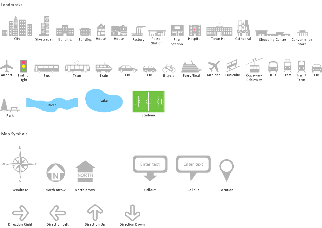
The vector stencils library "Landmarks" contains 34 signs and pictograms for drawing road and transit maps.
The vector stencils library "Map symbols" contains 10 signs and pictograms for drawing road and transit maps.
"A landmark is a recognizable natural or man-made feature used for navigation, a feature that stands out from its near environment and is often visible from long distances.
In modern use, the term can also be applied to smaller structures or features, that have become local or national symbols." [Landmark. Wikipedia]
The pictograms example "Design elements - Location map" was created using the ConceptDraw PRO diagramming and vector drawing software extended with the Spatial Infographics solution from the Maps area of ConceptDraw Solution Park.
Landmarks and Map symbols

 Directional Maps
Directional Maps solution extends ConceptDraw DIAGRAM software with templates, samples and libraries of vector stencils for drawing the directional, location, site, transit, road and route maps, plans and schemes.
This location map sample was created on the base on the map "Location of the Migration Health Assessment Center (MHAC)" from the website of the U.S. Embassy in Nepal. "Applicants for U.S. immigrant visas and transportation letters are required to have medical examinations performed by IOM (International Organization for Migration) Embassy panel physicians. ... Health assessments for the immigrants to the US are conducted by the International Organization for Migration (IOM) at the Migration Health Assessment Center."
[nepal.usembassy.gov/ visas/ immigrant-visas/ medical-exams.html]
The location map example "Location of the Migration Health Assessment Center (MHAC)" was created using the ConceptDraw PRO diagramming and vector drawing software extended with the Directional Maps solution from the Maps area of ConceptDraw Solution Park.
Location map
.png--diagram-flowchart-example.png)
Spatial infographics Design Elements: Transport Map

Map Infographic Design
Mind Maps for Business - SWOT Analysis
"A thematic map is a type of map or chart especially designed to show a particular theme connected with a specific geographic area. ...
A thematic map is a map that focuses on a specific theme or subject area, whereas in a general map the variety of phenomena - geological, geographical, political - regularly appear together. ...
Thematic maps emphasize spatial variation of one or a small number of geographic distributions. These distributions may be physical phenomena such as climate or human characteristics such as population density and health issues. ...
Thematic map are sometimes referred to as graphic essays that portray spatial variations and interrelationships of geographical distributions. Location, of course, is important to provide a reference base of where selected phenomena are occurring. ...
Thematic maps serve three primary purposes.
First, they provide specific information about particular locations.
Second, they provide general information about spatial patterns.
Third, they can be used to compare patterns on two or more maps." [Thematic map. Wikipedia]
The vector stencils library "Thematic maps" contains 7 continent map contours for creating the thematic maps of geographic regions displaying the metric values by countries, states and territories marked by different colors.
Use the design elements library "Thematic maps" to create spatial dashboards using the ConceptDraw PRO diagramming and vector drawing software for your Spatial Intelligence and Location Intelligence business practice.
The example "Design elements - Thematic maps" is included in the Spatial Dashboard solution from the area "What is a Dashboard" of ConceptDraw Solution Park.
Thematic map templates

HelpDesk
How to Create a Directional Map

Brilliant Examples of Infographics Map, Transport, Road

Flow Map
Vector Map of Germany

Geospatial Data
Map Infographic Tool

Directions Maps

- Location Map Template
- Directional Map Drawing Software
- Spatial infographics Design Elements: Location Map | Conference ...
- Location Direction Map
- Road Maps Location
- Brilliant Examples of Infographics Map , Transport, Road | Directional ...
- Location of the Migration Health Assessment Center (MHAC) | Mhac ...
- Spatial infographics Design Elements: Location Map | How to Create ...
- Spatial infographics Design Elements: Location Map | Map ...
- Design elements - Location map | Design elements - Landmarks ...
- Conference centre location map | Map Infographic Tool | Spatial ...
- How To Draw Building Plans | Design elements - Location map ...
- Conference centre location map | Directional Maps | 2D Directional ...
- Spatial infographics Design Elements: Location Map | Process ...
- Design elements - Location map | Road signs - Vector stencils ...
- Design elements - Location map | Landmarks - Vector stencils ...
- Map symbols - Vector stencils library | Design elements - Location ...
- Landmarks - Vector stencils library | Design elements - Location ...
- Spatial infographics Design Elements: Location Map | How To use ...