Geo Map — USA — Iowa
Maps of USA — State of Iowa
"Iowa is a U.S. state in the Midwestern United States, a region sometimes called the "American Heartland". Iowa is bordered by the Mississippi River on the east and the Missouri River and the Big Sioux River on the west; it is the only US state whose eastern and western borders are formed entirely by rivers. Iowa is bordered by Wisconsin and Illinois to the east, Missouri to the south, Nebraska and South Dakota to the west, and Minnesota to the north." [Iowa. Wikipedia]
The vector stencils library Iowa contains contours for ConceptDraw DIAGRAM diagramming and vector drawing software. This library is contained in the Continent Maps solution from Maps area of ConceptDraw Solution Park.

Pic. 1. Continent Maps Solution
Use the Iowa library to draw thematic maps, geospatial infographics and vector illustrations for your business documents, presentations and websites.
Geo Map — USA — State of Iowa
Area 56,272.81 sq mi (145,746 km2); Width 360 miles (580 km); Length 199 miles (320 km).

Pic. 2. State of Iowa
Geo Map — USA — Iowa Contour
Capital — Des Moines.

Pic. 3. State of Iowa Contour
Geo Map — USA
The United States of America, is a federal republic composed of 50 states, a federal district, five major territories.

Pic. 4. USA Map
Geo Map — USA Contour
A contour map is a map illustrated with contour lines.

Pic. 5. USA Contour
Geo Map — Contours of Territories of the United States
Use the map contours library "United States of America" to design thematic maps using the ConceptDraw DIAGRAM diagramming and vector drawing software.
The vector stencils library "United States of America" contains 53 map contours: US political map, map contours of states.

Pic. 6. Contours of Territories of the United States
All ConceptDraw DIAGRAM documents are vector graphic files and are available for reviewing, modifying, and converting to a variety of formats: image, HTML, PDF file, MS PowerPoint Presentation, Adobe Flash, MS Visio (.VDX, .VSDX).
See Also Territories of the United States Geo Maps :
TEN RELATED HOW TO's:
The vector stencils library Norway contains contours for ConceptDraw DIAGRAM diagramming and vector drawing software. This library is contained in the Continent Maps solution from Maps area of ConceptDraw Solution Park.
Picture: Geo Map - Europe - Norway
Related Solution:
Connecticut is the southernmost state in the northeastern region of the United States known as New England.
The vector stencils library Connecticut contains contours for ConceptDraw DIAGRAM diagramming and vector drawing software. This library is contained in the Continent Maps solution from Maps area of ConceptDraw Solution Park.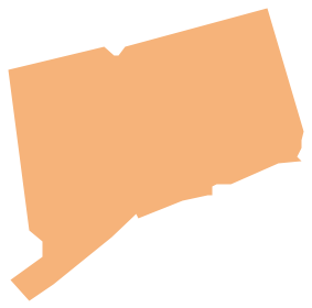
Picture: Geo Map - USA - Connecticut
Related Solution:
West Virginia is a U.S. state located in the Appalachian region of the Southern United States.
The vector stencils library West Virginia contains contours for ConceptDraw DIAGRAM diagramming and vector drawing software. This library is contained in the Continent Maps solution from Maps area of ConceptDraw Solution Park.
Picture: Geo Map - USA - West Virginia
Related Solution:
Idaho is a state in the northwestern region of the United States.
The vector stencils library Idaho contains contours for ConceptDraw DIAGRAM diagramming and vector drawing software. This library is contained in the Continent Maps solution from Maps area of ConceptDraw Solution Park.
Picture: Geo Map - USA - Idaho
Related Solution:
ConceptDraw defines some map types, divided into three categories. Every map type has specific shapes and examples.
Picture: Types of Map - Overview
Related Solution:
Guyana, officially the Co-operative Republic of Guyana, is a sovereign state on the northern coast of South America.
The vector stencils library Guyana contains contours for ConceptDraw DIAGRAM diagramming and vector drawing software. This library is contained in the Continent Maps solution from Maps area of ConceptDraw Solution Park.
Picture: Geo Map - South America - Guyana
Related Solution:
Ontario is one of the ten provinces of Canada, located in east-central Canada.
The vector stencils library Ontario contains contours for ConceptDraw DIAGRAM diagramming and vector drawing software. This library is contained in the Continent Maps solution from Maps area of ConceptDraw Solution Park.
Picture: Geo Map - Canada - Ontario
Related Solution:
The vector stencils library Germany contains contours for ConceptDraw DIAGRAM diagramming and vector drawing software. This library is contained in the Continent Maps solution from Maps area of ConceptDraw Solution Park.
Picture: Geo Map — Europe — Germany
Related Solution:
The Philippines, officially known as the Republic of the Philippines, is a sovereign island country in Southeast Asia situated in the western Pacific Ocean.
Use the Continent Maps solution and Philippines library to draw thematic maps, geospatial infographics and vector illustrations. This solution to help visualize the business and thematic information connected with geographic areas, locations or customs; for your business documents, presentations and websites.
Picture: Geo Map - Asia - Philippines
Related Solution:
Nevada is a state in the western, mountain west, and southwestern regions of the United States.
The vector stencils library Nevada contains contours for ConceptDraw DIAGRAM diagramming and vector drawing software. This library is contained in the Continent Maps solution from Maps area of ConceptDraw Solution Park.
Picture: Geo Map - USA - Nevada
Related Solution:


