Geo Map - South America - Chile
Maps of South America - Republic of Chile
"Chile, officially the Republic of Chile, is a South American country occupying a long, narrow strip of land between the Andes mountains to the east and the Pacific Ocean to the west. It borders Peru to the north, Bolivia to the northeast, Argentina to the east, and the Drake Passage in the far south. Chilean territory includes the Pacific islands of Juan Fernández, Salas y Gómez, Desventuradas, and Easter Island. Chile also claims about 1,250,000 square kilometres (480,000 sq mi) of Antarctica, although all claims are suspended under the Antarctic Treaty." [Chile. Wikipedia]
The vector stencils library Chile contains contours for ConceptDraw DIAGRAM diagramming and vector drawing software. This library is contained in the Continent Maps solution from Maps area of ConceptDraw Solution Park.

Pic. 1. Continent Maps Solution
Use the Chile library to draw thematic maps, geospatial infographics and vector illustrations for your business documents, presentations and websites.
Geo Map - South America - Republic of Chile
Chile is divided into 15 regions, each headed by an intendant appointed by the president.

Pic. 2. Republic of Chile
Geo Map - South America - Chile Contour
Capital - Santiago

Pic. 3. Chile Contour
Geo Map - South America
South America includes 27 states.

Pic. 4. South America
Geo Map - South America Contour
A contour map is a map illustrated with contour lines.

Pic. 5. South America Contour
Geo Map - South America Flags

Pic. 6. South America Flags
Geo Map - contours of South America countries
Use the map contours library "South America" to design thematic maps of South American countries using the ConceptDraw DIAGRAM diagramming and vector drawing software.
The vector stencils library "South America" contains 29 map contours: South America political map, Central America political map, state map contours of South American countries.

Pic. 7. Contours of South America countries
Geo Map - Languages of South America
"Spanish and Portuguese are the most spoken languages in South America, with approximately 200 million speakers each. Spanish is the official language of most countries, along with other native languages in some countries. Portuguese is the official language of Brazil. Dutch is the official language of Suriname; English is the official language of Guyana, although there are at least twelve other languages spoken in the country, including Portuguese, Chinese, Hindustani and several native languages. English is also spoken in the Falkland Islands. French is the official language of French Guiana and the second language in Amapá, Brazil.
Indigenous languages of South America include Quechua in Ecuador, Peru, Chile, Colombia, and Bolivia; Wayuunaiki in northern Colombia (La Guajira) and northwestern Venezuela (Zulia); Guaraní in Paraguay and, to a much lesser extent, in Bolivia; Aymara in Bolivia, Peru, and less often in Chile; and Mapudungun is spoken in certain pockets of southern Chile and, more rarely, Argentina. At least three South American indigenous languages (Quechua, Aymara, and Guarani) are recognized along with Spanish as national languages."
[South America. Wikipedia]
This example is created using ConceptDraw DIAGRAM diagramming software enhanced with Continent Maps solution from ConceptDraw Solution Park.

Pic. 8. Languages of South America
All ConceptDraw DIAGRAM documents are vector graphic files and are available for reviewing, modifying, and converting to a variety of formats: image, HTML, PDF file, MS PowerPoint Presentation, Adobe Flash, MS Visio (.VDX, .VSDX).
See also Geo Maps of South America Countries :
NINE RELATED HOW TO's:
No one can imagine a geography class without such educational stuff as a geo map or a globe. As for one of the biggest countries in North America, the United States of America Map is present in every American school or college. It’s easier to remember all the states if you look on the map more often.
The following sample represents the map of USA. This precise map has names of all states of America. The different colors which are used to indicate each state add the visuality and brightness to the whole map. The ConceptDraw USA Maps solution - one of a family of ConceptDraw Maps solutions. Any country invokes a big piece of data: geographical, political, statistical, etc. A simple way of representing this data is to design maps that will show a certain item in relation to a particular area of Earth.
Picture: Geo Map — United States of America Map
Related Solution:
A continent is one of several very large landmasses on Earth. ConceptDraw DIAGRAM diagramming and vector drawing software offers the unique Continent Maps Solution from the Maps Area which is indispensable for drawing the map of continents of the Earth.
Picture: Map of Continents
Related Solution:
Michigan is a state in the Great Lakes region of the Midwestern United States.
The vector stencils library Michigan contains contours for ConceptDraw DIAGRAM diagramming and vector drawing software. This library is contained in the Continent Maps solution from Maps area of ConceptDraw Solution Park.
Picture: Geo Map — USA — Michigan
Related Solution:
Nunavut is the largest, northernmost and newest territory of Canada.
The vector stencils library Nunavut contains contours for ConceptDraw DIAGRAM diagramming and vector drawing software. This library is contained in the Continent Maps solution from Maps area of ConceptDraw Solution Park.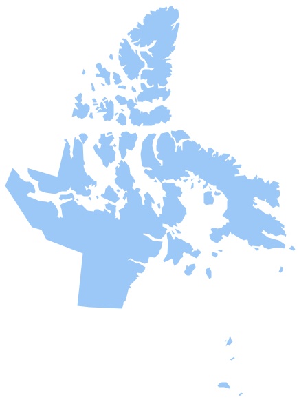
Picture: Geo Map - Canada - Nunavut
Related Solution:
Peru, officially the Republic of Peru, is a country in western South America.
The history of Peru goes back to the distant past and its divided into several main stages. Geography of Peru is also diverse - there is a desert, as well as the ocean coast, and of course the mountain ranges.
The Continent Maps solution from Maps area of ConceptDraw Solution Park provides stencil library Peru, which is made up of well-designed vector shapes delivering easy experience in creating diagrams with ConceptDraw DIAGRAM software.
All ConceptDraw DIAGRAM documents are vector graphic files and are available for reviewing, modifying, and converting to a variety of formats: image, HTML, PDF file, MS PowerPoint Presentation, Adobe Flash, MS Visio (.VDX,.VSDX).
Picture: Geo Map — South America — Peru
Related Solution:
The Dominican Republic is a nation on the island of Hispaniola, part of the Greater Antilles archipelago in the Caribbean region.
The vector stencils library Dominican Republic contains contours for ConceptDraw DIAGRAM diagramming and vector drawing software. This library is contained in the Continent Maps solution from Maps area of ConceptDraw Solution Park.
Picture: Geo Map - South America - Dominican Republic
Related Solution:
Guyana, officially the Co-operative Republic of Guyana, is a sovereign state on the northern coast of South America.
The vector stencils library Guyana contains contours for ConceptDraw DIAGRAM diagramming and vector drawing software. This library is contained in the Continent Maps solution from Maps area of ConceptDraw Solution Park.
Picture: Geo Map - South America - Guyana
Related Solution:
Belize is a country on the northeastern coast of Central America.
The vector stencils library Belize contains contours for ConceptDraw DIAGRAM diagramming and vector drawing software. This library is contained in the Continent Maps solution from Maps area of ConceptDraw Solution Park.
Picture: Geo Map - South America - Belize
Related Solution:
Mexico, officially the United Mexican States, is a federal republic in North America.
The vector stencils library Mexico contains contours for ConceptDraw DIAGRAM diagramming and vector drawing software. This library is contained in the Continent Maps solution from Maps area of ConceptDraw Solution Park.
Picture: Geo Map - South America - Mexico
Related Solution:


