 Metro Map Solution. ConceptDraw.com
Metro Map solution extends ConceptDraw DIAGRAM software with templates,
samples and library of vector stencils for drawing the metro maps , route maps ,
bus
Wikipedia] This route map example was redesigned from the Wikimedia
Commons The example "ARL route map " was created using the ConceptDraw
PRO
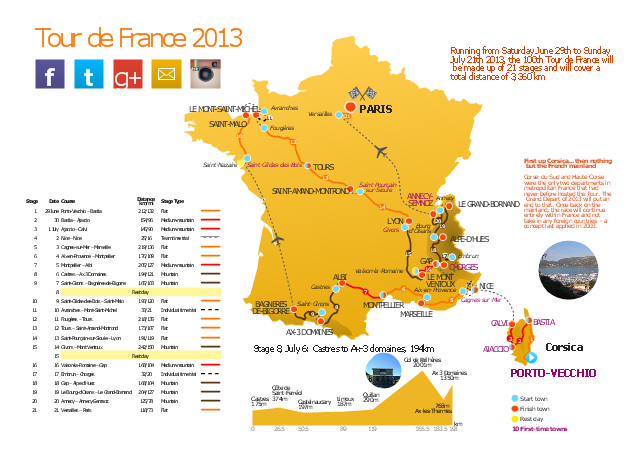
This route map example was redesigned from the Wikipedia file: Route of the
2013 Tour de France.png.
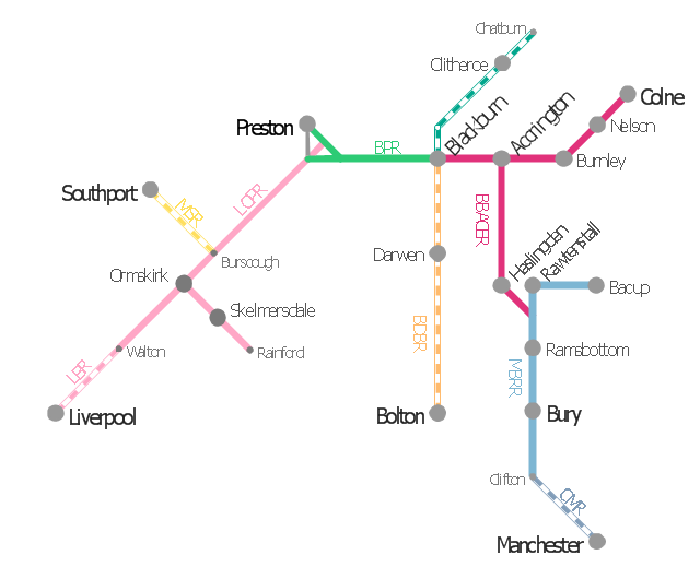
This is example of route map for the former East Lancashire Railway, in
Lancashire, England. It was redesigned from the Wikimedia Commons file: ELR
route
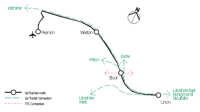
Additionally, the links benefit airports by drawing in more passengers via easy
access." [Airport rail link. Wikipedia] This route map example was redesigned
from

Use this template for creating the directional maps , location plans, site schemes,
transit schemes, road maps , route maps . "A road map or route map is a map


HelpDesk
Saving Metro Map as Web Page. ConceptDraw HelpDesk
ConceptDraw DIAGRAM enables designing metro maps , route maps , and various transport schemes. You can easily make a map , and save it as a Web page.
Los Angeles Metro Rail and Liner

How to draw Metro Map style infographics
ConceptDraw sample of Metro Map style infographics tube map Los Angeles Metro Rail and Liner - how to draw metro maps using solution Metro Map
How to draw Metro Map style infographics? (Moscow) *
</i> *")
How to draw Metro Map style infographics
ConceptDraw sample of Metro Map style infographics Moscow Metro - how to draw metro maps using solution Metro MapInfographic software: the sample of New York City Subway map *

Infographic software: the sample of New York City Subway map
ConceptDraw infographics software sample New York City Subway - how to draw maps using solution Metro Map
The 3D pictorial street maps are used as road maps , route maps , locator maps ,
transit maps , directional maps , tourist maps with points of interest (POI). "A point
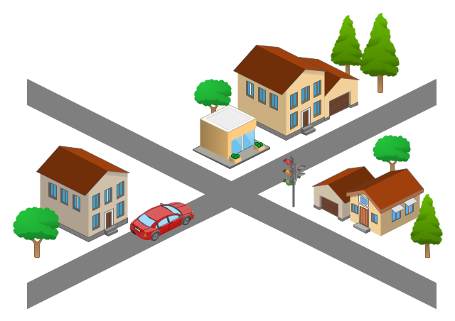
Use this template for creating the 3D pictorial road maps , directional maps ,
location plans, site plans, transit maps , route maps . " Road maps can vary in
Types of Map - Overview *

Types of Map - Overview
ConceptDraw defines some map types, divided into three categories. Metro Map to create metro maps , route maps , bus, transit maps and other transportInfographic design elements, software tools
Subway and Metro style *
Subway and Metro style *

Infographic Design Elements. Metro Map Style, Subway Style (vector)
ConceptDraw inforgraphic software subway style design elements sample metro map solution
" Road maps come in many shapes, sizes and scales. Small, single-page maps
may be used to give an overview of a region's major routes and features.

- ELR route map | The 100th Tour de France - Route map | Metro ...
- ARL route map | How to Make a Web Page from Your Metro Map ...
- 2D Directional map - Template
- The 100th Tour de France - Route map | How to Create a Powerful ...
- 3D pictorial road map | ARL route map | Rolla USGS Center locator ...
- ELR route map
- The 100th Tour de France - Route map | Aircraft - Vector stencils ...
- Directional Maps | Maps Driving Directions | Map Directions ...
- Metro Maps | ELR route map | How to Make a Web Page from Your ...
- Directional Maps | Software For Making Bus Route Diagrammatic ...
- ELR route map | Subway Train Map | Metro Map | Elr Maps
- ARL route map
- The 100th Tour de France - Route map | How To use House ...
- The 100th Tour de France - Route map
- Subway Train Map | How to draw Metro Map style infographics ...
- Road Maps
- Superb Examples of Infographic Maps | The 100th Tour de France ...
- Directional Maps | How to Create a Directional Map | 2D Directional ...
- Road Map Symbols
- Directional Maps | Map Directions | Road signs - Vector stencils ...