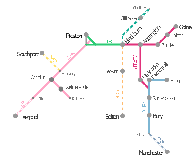
This is example of route map for the former East Lancashire Railway, in Lancashire, England.
It was redesigned from the Wikimedia Commons file: ELR route map.png. [commons.wikimedia.org/ wiki/ File:ELR_ route_ map.png]
This file is licensed under the Creative Commons Attribution-Share Alike 3.0 Unported license. [creativecommons.org/ licenses/ by-sa/ 3.0/ deed.en]
The example "ELR route map" was created using the ConceptDraw PRO diagramming and vector drawing software extended with the Metro Map solution from the Maps area of ConceptDraw Solution Park.
Route map
Subway Train Map

 Metro Map
Metro Map solution extends ConceptDraw PRO software with templates, samples and library of vector stencils for drawing the metro maps, route maps, bus and other transport schemes, or design tube-style infographics.
Metro Train Map

- ELR route map
- ELR route map | The 100th Tour de France - Route map | ARL route ...
- How To Draw Indian Railway Route Map
- Software For Making Bus Route Diagrammatic Maps
- Tourist Map Software
- Design elements - Transport map | Train Icon Transparent Background
- How to draw Metro Map style infographics? (Los Angeles) | Rail ...
- How to draw Metro Map style infographics? Moscow, New York, Los ...
- Metro Map | How to draw Metro Map style infographics? Moscow ...
- How to draw Metro Map style infographics? (London) | How to draw ...
- Metro Map
- Design elements - 3D directional maps | 3d Illustrated Map Of A Route
- Metro Map | How to draw Metro Map style infographics? Moscow ...
- 2D Directional map
- Metro Maps | Subway Train Map | Metro Map | Route Map Easy ...
- MTA Subway Map | Entity-Relationship Diagram (ERD) | Metro Map ...
- Design elements - 3D directional maps | Electric and Telecom Plans ...
- Metro Train Map
- Metro Map | Emergency Plan | Fire Exit Plan. Building Plan ...
- Transit map template | Transport map - Template | New York City ...