How to draw Metro Map style infographics? (Los Angeles)

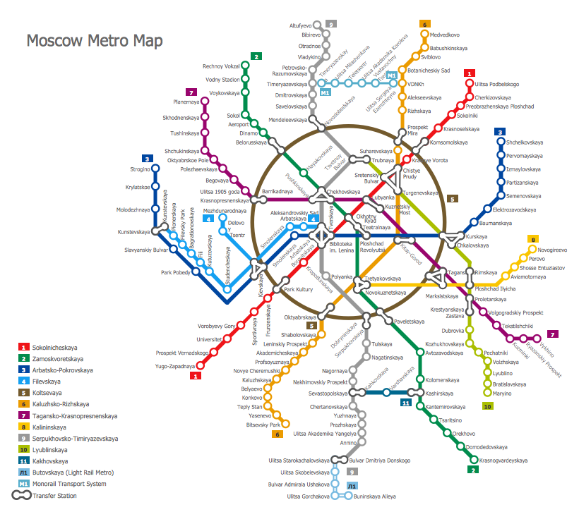
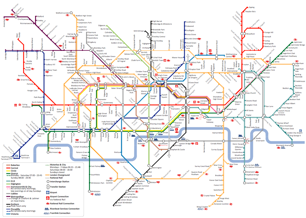
How to draw Metro Map style infographics? Moscow, New York, Los Angeles, London

Subway Map
Metro Map
 Metro Map
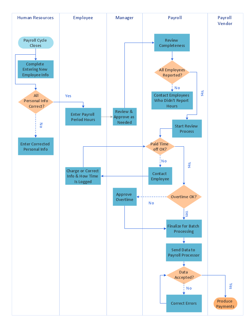
Metro Map solution extends ConceptDraw DIAGRAM software with templates, samples and library of vector stencils for drawing the metro maps, route maps, bus and other transport schemes, or design tube-style infographics.
How to draw Metro Map style infographics? (New York)

 Metro Map
Metro Map solution extends ConceptDraw DIAGRAM software with templates, samples and library of vector stencils for drawing the metro maps, route maps, bus and other transport schemes, or design tube-style infographics.
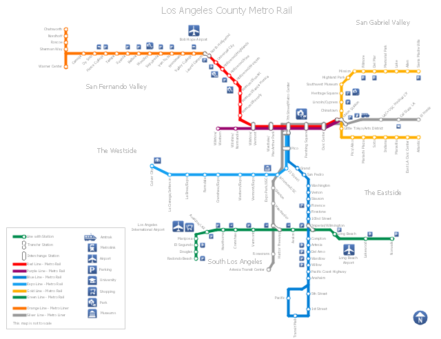
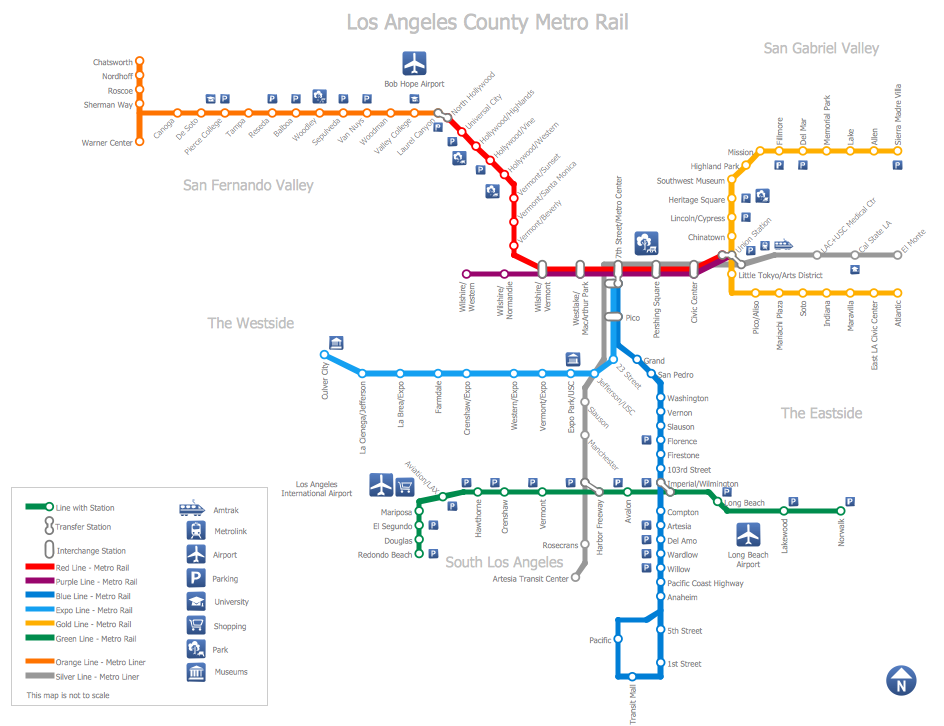
"Metro Rail is an urban rail system serving Los Angeles County, California. It consists of six lines, including two rapid transit subway lines (the Red and Purple Lines) and four light rail lines (the Blue, Green, Gold and Expo lines) serving 80 stations. It connects with the Metro Liner bus rapid transit system (the Orange Line and Silver Line) and also with the Metrolink commuter rail systems. The system, which has an average daily weekday ridership of 362,904 as of June 2012, is owned and operated by the Los Angeles County Metropolitan Transportation Authority (Metro) and started service in 1990. It has been extended significantly since that time and several further extensions are either in the works or being considered.
It is the indirect descendant of the Pacific Electric Red Car and Los Angeles Railway Yellow Car lines, which operated between the late 19th century and the 1960s." [Metro Rail (Los Angeles County). Wikipedia]
The transit map example "Los Angeles county Metro Rail map" was created using the ConceptDraw PRO diagramming and vector drawing software extended with the Metro Map solution from the Maps area of ConceptDraw Solution Park.
Los Angeles metro map
Concept Maps

Map Infographic Creator
Cross-Functional Flowchart (Swim Lanes)
Mac Compatible Remote Presentation


Social Media Marketing Infographic

Road Transport - Design Elements
Subway Train Map
- Los Angeles county Metro Rail map | How to draw Metro Map style ...
- How to draw Metro Map style infographics? Moscow, New York, Los ...
- How to draw Metro Map style infographics? ( Los Angeles ) | Los ...
- La Subway Map Pdf
- How to draw Metro Map style infographics? Moscow, New York, Los ...
- Los Angeles county Metro Rail map | Metro Map | How to draw Metro ...
- Los Angeles Subway Map Pdf
- Metro Train Map
- How to draw Metro Map style infographics? ( Los Angeles )
- Los Angeles Metro Train Map
- How to draw Metro Map style infographics? Moscow, New York, Los ...
- How to draw Metro Map style infographics? Moscow, New York, Los ...
- How to draw Metro Map style infographics? Moscow, New York, Los ...
- How to draw Metro Map style infographics? Moscow, New York, Los ...
- La Metro Map
- How to draw Metro Map style infographics? Moscow, New York, Los ...
- Metro Line Map Los Angeles
- Metro Map | How to draw Metro Map style infographics? ( Los ...
- Map Of Subway Los Angeles
- MTA Subway Map