The vector stencils library "Recreation signs" contains 28 pictogram symbols for labeling the street and locator maps, road and route maps, transit and tourist maps with information signs using the ConceptDraw PRO diagramming and vector drawing software.
"An information sign is a very legibly printed and very noticeable placard that informs people of the purpose of an object, or gives them instruction on the use of something. An example is a traffic sign such as a stop sign.
Information signs have been growing in visibility due to the explosion of sign technologies." [Information sign. Wikipedia]
"A tourist sign, often referred to as a brown sign, is a traffic sign whose purpose is to direct visitors to tourist destinations, such as historic buildings, tourist regions, caravan or camp sites, picnic areas, sporting facilities and cultural places such as museums. By international convention, brown signs with white lettering and white pictograms are often used for this purpose." [Tourist sign. Wikipedia]
The vector stencils library "Recreation signs" is included in the Directional Maps solution from the Maps area of ConceptDraw Solution Park.
Recreation signs

Sign Making Software

The vector stencils library "Recreation signs" contains 28 pictogram symbols of recreation signs for labeling street and directional maps, locator and tourist maps, road and route maps.
"A tourist sign, often referred to as a brown sign, is a traffic sign whose purpose is to direct visitors to tourist destinations, such as historic buildings, tourist regions, caravan or camp sites, picnic areas, sporting facilities and cultural places such as museums. By international convention, brown signs with white lettering and white pictograms are often used for this purpose. ...
Basically these tourist signs have 3 main applications:
(1) Information signs and signposts that point to important tourist destinations or places of interest in the local area, for example within a village or town.
(2) Standard signs that are used to mark routes with special themes, i.e. so-called tourist or holiday routes.
(3) Tourist signs that herald the presence of nearby landscapes, towns and regions, usually on long distance routes such as motorways. They are not used as direction signs." [Tourist sign. Wikipedia]
The pictograms example "Recreation signs - Vector stencils library" was created using the ConceptDraw PRO diagramming and vector drawing software extended with the Directional Maps solution from the Maps area of ConceptDraw Solution Park.
www.conceptdraw.com/ solution-park/ maps-directional
Parking

Amphitheater

Campfire

Cross-country skiing

Volleyball

Supplies/store

Climbing

Handball/racquetball

Boat launch

Downhill skiing

Shower

Fishing

Golf

Skating

Canoe access

Horseback riding

Tennis

Kayaking

Marina

Hiking

Snowboarding

Scuba diving

Swimming

Snowmobile

Restroom

Potable water

Campground

RV

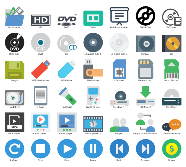
The vector stencils library "Media" contains 42 multimedia icons.
Use it to design your audio, video and multimedia illustrations, presentations, web pages and infographics with ConceptDraw PRO diagramming and vector drawing software.
"Multimedia is content that uses a combination of different content forms such as text, audio, images, animation, video and interactive content. ...
Multimedia can be recorded and played, displayed, dynamic, interacted with or accessed by information content processing devices, such as computerized and electronic devices, but can also be part of a live performance. Multimedia devices are electronic media devices used to store and experience multimedia content." [Multimedia. Wikipedia]
The clipart example "Media" is included in the Audio, Video, Media solution from the Illustrations area of ConceptDraw Solution Park.
Multimedia clipart
The vector stencils library "Road signs" contains 58 symbols of road signs for labeling the road and route maps, directional and transit maps, street and locator maps.
"Traffic signs or road signs are signs erected at the side of or above roads to give instructions or provide information to road users.
... many countries have adopted pictorial signs or otherwise simplified and standardized their signs to overcome language barriers, and enhance traffic safety. Such pictorial signs use symbols (often silhouettes) in place of words and are usually based on international protocols. Such signs were first developed in Europe, and have been adopted by most countries to varying degrees." [Traffic sign. Wikipedia]
The pictograms example "Road signs - Vector stencils library" was created using the ConceptDraw PRO diagramming and vector drawing software extended with the Directional Maps solution from the Maps area of ConceptDraw Solution Park.
www.conceptdraw.com/ solution-park/ maps-directional
Danger place

Intersection

Intersection 2

Bend

Double bend

Two-way traffic

Mobile bridge

Light signal

Pedestrian crossing

Road work

Back-up

Give way

Crossing

Stop

Roundabout

Pass this side

Direction to be followed

One-way street

Cycle track

No entry

No entry both directions

No power vehicles

No U-turns

No passing without stopping

No standing and parking

No parking

Speed limit

Height limit

Width limit

Weight limit

Priority over oncoming traffic

Streetcar or regular buses

Taxi status

Beginning that speed 30-Zone

End that speed 30-Zone

Pedestrian crossing 2

Police

Hotel

Breakdown service

Restaurant

P + R

Restroom

Fuel

Telephone

Recommended speed

Nodal point of a motorwa

Parking

Dead end

Motorway

End motorway

Populated zone

End populated zone

Parking with clock

Number sign (motorway)
-road-signs---vector-stencils-library.png--diagram-flowchart-example.png)
Exit

Direction to place

Board of announcement of exit

Number sign (federal highway)
-road-signs---vector-stencils-library.png--diagram-flowchart-example.png)
The vector stencils library "Road signs" contains 58 symbols of traffic signs for labeling the road and route maps, street and locator maps, transit and directional maps using the ConceptDraw PRO diagramming and vector drawing software.
"Traffic signs or road signs are signs erected at the side of or above roads to give instructions or provide information to road users. ...
With traffic volumes increasing since the 1930s, many countries have adopted pictorial signs or otherwise simplified and standardized their signs to overcome language barriers, and enhance traffic safety. Such pictorial signs use symbols (often silhouettes) in place of words and are usually based on international protocols. Such signs were first developed in Europe, and have been adopted by most countries to varying degrees." [Traffic sign. Wikipedia]
The vector stencils library "Road signs" is included in the Directional Maps solution from the Maps area of ConceptDraw Solution Park.
Road signs

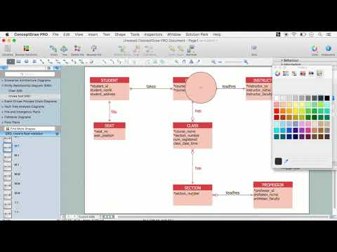
ERD Symbols and Meanings

Basic Flowchart Symbols and Meaning


How to Create Flowcharts for an Accounting Information System

Garrett IA Diagrams with ConceptDraw PRO

HelpDesk
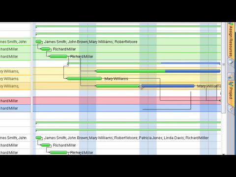
What Information to be Displayed in the ConceptDraw PROJECT Gantt Chart View

Pyramid Diagram

HelpDesk
Accounting Information Systems Flowchart Symbols

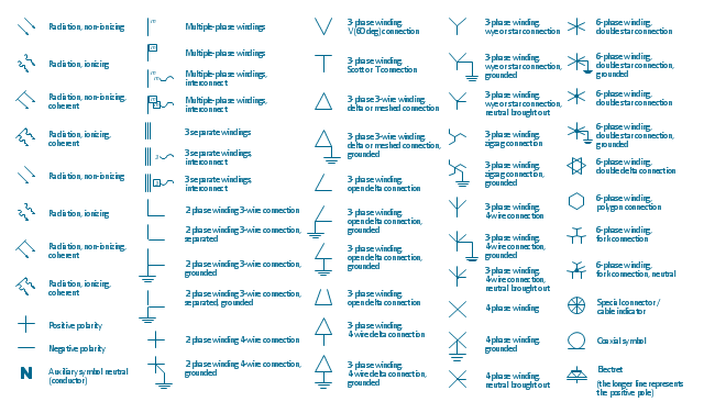
The vector stencils library "Qualifying" contains 56 qualifying symbols of radiation, polarity, phase, windings, wire, ground, connection, connector, coaxial, electret.
Use these signs to annotate or specify characteristics of objects in electrical drawings, electronic schematics, circuit diagrams, electromechanical drawings, and wiring diagrams, cabling layout diagrams.
"An electrical drawing, is a type of technical drawing that shows information about power, lighting, and communication for an engineering or architectural project. Any electrical working drawing consists of "lines, symbols, dimensions, and notations to accurately convey an engineering's design to the workers, who install the electrical system on the job".
A complete set of working drawings for the average electrical system in large projects usually consists of:
(1) A plot plan showing the building's location and outside electrical wiring.
(2) Floor plans showing the location of electrical systems on every floor.
(3) Power-riser diagrams showing panel boards.
(4) Control wiring diagrams.
(5) Schedules and other information in combination with construction drawings.
Electrical drafters prepare wiring and layout diagrams used by workers who erect, install, and repair electrical equipment and wiring in communication centers, power plants, electrical distribution systems, and buildings." [Electrical drawing. Wikipedia]
The signs example "Design elements - Qualifying" was drawn using the ConceptDraw PRO diagramming and vector drawing software extended with the Electrical Engineering solution from the Engineering area of ConceptDraw Solution Park.
Qualifying symbols
Concept Maps

- Diagram Of Information Road Signs
- Road signs - Vector stencils library | Design elements - Road signs ...
- Sign Making Software | ConceptDraw Software Full Versions Free ...
- Recreation signs - Vector stencils library | Design elements ...
- Recreation signs - Vector stencils library | Funny transport - Vector ...
- Design elements - Road signs | Design elements - 3D directional ...
- Recreation signs - Vector stencils library | Recreation signs - Vector ...
- Recreation signs - Vector stencils library | Interior Design Sport ...
- Shopping pictograms - Vector stencils library | Recreation signs ...
- Road signs - Vector stencils library | Maps and Directions | Map ...
- Recreation signs - Vector stencils library | Travel and tourism ...
- Design elements - Winter sports pictograms | Winter Sports ...
- Road signs - Vector stencils library | Media signs - Vector stencils ...
- Design elements - Road signs | Road Transport - Design Elements ...
- Recreation signs - Vector stencils library | Road signs - Vector ...
- Road signs - Vector stencils library | Design elements - Recreation ...
- Swim Lane Diagrams | Swim Lanes Flowchart. Flowchart Examples ...
- 2D Directional map - Template | Maps Driving Directions ...
- Design elements - Power sources | Recreation signs - Vector ...