Geo Map — United States of America Map

Map of USA States

Map of USA

 USA Maps
Use the USA Maps solution to create a map of USA, a US interstate map, printable US maps, US maps with cities and US maps with capitals. Create a complete USA states map.
Vector Map of Germany

Geo Mapping Software Examples - World Map Outline

"A state of the United States of America is one of the 50 constituent political entities that shares its sovereignty with the United States federal government."
[U.S. state. Wikipedia]
This political map example was redesigned from the Wikimedia Commons file: Map of USA with state names 2.svg.
[commons.wikimedia.org/ wiki/ File:Map_ of_ USA_ with_ state_ names_ 2.svg]
This file is licensed under the Creative Commons Attribution-Share Alike 3.0 Unported license. [creativecommons.org/ licenses/ by-sa/ 3.0/ deed.en]
The example "Map of USA with state names" was created using the ConceptDraw PRO diagramming and vector drawing software extended with the Continent Map solution from the Maps area of ConceptDraw Solution Park.
Political map - USA

Geo Map of Americas

USA Map

Geo Map — USA — Washington

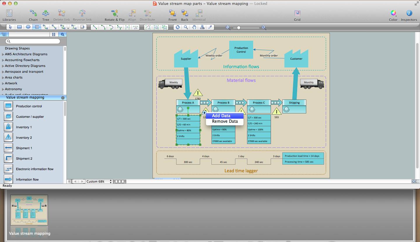
Lean Six Sigma Diagram Software
Maps of Germany With Cities

How to draw Metro Map style infographics? (New York)

Map Software

- Us Thematic Map Example
- Map Of Pest Control Business Over The United States
- Geo Map - United States of America Map | Map of USA with state ...
- The United States World Map
- Geo Map - United States of America Map | Map of USA with state ...
- Geo Map - United States of America Map | Ranks US states by ...
- Continent Maps | Geo Map - United States of America Map | Map of ...
- Maps United States Of America
- United States Of America World Map
- Geo Map - United States of America Map | U.S. primary energy ...
- Map Of United States With State Names
- Redesigned Map Of United States
- Geo Map - United States of America Map
- Map of USA | Geo Map - United States of America Map | Design ...
- Geo Map - United States of America Map | USA Map States | Map of ...
- Geo Map - United States of America Map | How to Draw a Map of ...
- Geo Map - United States of America Map
- Geo Map - United States of America Map
- Geo Map - United States of America Map | Continent Maps ...