
Example 1. USA Map - New York Counties
USA Maps Solution includes the extensive set of drawing tools and 9 libraries with 52 ready-to-use vector map objects representing all USA states.
The objects from these libraries, and also predesigned template and collection of samples offered in ConceptDraw STORE will allow you instantly draw the USA Map and various thematic USA Maps. Thanks to the ConceptDraw DIAGRAM software we always have excellent result - professional looking maps which can be successfully used on various conferences and presentations, in publications, reference guides and infographics.
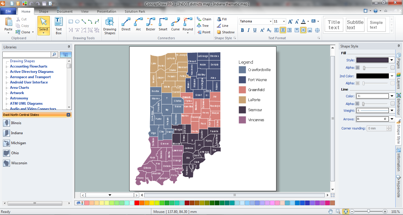
Example 2. Indiana Thematic Map in ConceptDraw DIAGRAM /p>
Use bright colors to make your map more attractive, highlight by colors the names of large cities, capitals. Sometimes can be useful to highlight several county areas on the map, ConceptDraw DIAGRAM gives you this possibility too.
You can also add the legend to make your map more informative and comprehensible.

Example 3. USA Map - Texas Counties Map
This sample was created in ConceptDraw DIAGRAM software using the tools of the USA Maps solution. It shows the part of USA Map - detailed Texas counties map. An experienced user spent 20 minutes creating this sample.
Use the USA Maps solution for ConceptDraw DIAGRAM software to design your own USA Map quick, easy and effective, and then successfully use it in your life or work activity.
All source documents are vector graphic documents. They are available for reviewing, modifying, or converting to a variety of formats (PDF file, MS PowerPoint, MS Visio, and many other graphic formats) from the ConceptDraw STORE. The USA Maps Solution is available for all ConceptDraw DIAGRAM or later users.
TEN RELATED HOW TO's:
How to design USA map fast and easy? It is convenient to use special software. ConceptDraw DIAGRAM diagramming and vector drawing software includes the USA Maps Solution which was specially developed to make easier drawing process of USA Maps, Map of USA States, various USA thematic maps and cartograms.
Picture: Map of USA States
Related Solution:
Usually designing of maps, including the USA Map is a quite complex, long and labour-intensive process. But now we have an excellent possibility to make it easier with ConceptDraw DIAGRAM diagramming and vector drawing software extended with powerful USA Maps Solution from the Maps Area of ConceptDraw Solution Park.Picture: USA Map
Related Solution:
ConceptDraw DIAGRAM diagramming and vector drawing software enhanced with USA Maps Solution from the Maps Area of ConceptDraw Solution Park is the best for drawing various kinds of USA Maps, thematic maps of any detailing, pictorial map of USA states.
Picture: USA Maps
Related Solution:
No one can imagine a geography class without such educational stuff as a geo map or a globe. As for one of the biggest countries in North America, the United States of America Map is present in every American school or college. It’s easier to remember all the states if you look on the map more often.
The following sample represents the map of USA. This precise map has names of all states of America. The different colors which are used to indicate each state add the visuality and brightness to the whole map. The ConceptDraw USA Maps solution - one of a family of ConceptDraw Maps solutions. Any country invokes a big piece of data: geographical, political, statistical, etc. A simple way of representing this data is to design maps that will show a certain item in relation to a particular area of Earth.
Picture: How to Draw the US Map? ConceptDraw Diagram Software for Easy USA Map Drawing
Related Solution:
Vector map is the best way to visually present a world, continents, islands, to display location and boundaries of countries and cities. ConceptDraw DIAGRAM diagramming and vector drawing software offers the Germany Map Solution from the Maps Area of ConceptDraw Solution Park - the best tool for fast and easy drawing vector map of Germany of any degree of detailing, and thematic cartograms and maps of Germany on its base.
Picture: Vector Map of Germany
Related Solution:
If you are an advanced diagramming software user, you might use it daily. Traversing the Internet in searching of alternative to MS Visio for MAC and PC, you can fulfill all your requirements with ConceptDraw DIAGRAM. Don’t hesitate to transfer your documents to another operating system.
When looking for a smart and simple tool for business diagrams as alternative to MS Visio for Apple OS X platform, ConceptDraw DIAGRAM certainly is the best choice. Making many kinds of business charts, numerous technical drawings is what ConcepDraw DIAGRAM is the best. One can easy create any diagram and complete it perfectly and quickly. The big collection of vector object libraries, templates and samples, make it the best Microsoft Visio alternative: ConceptDraw DIAGRAM is simpler to use, less expensive, and supports project management and mind mapping methods.
Picture:
In Searching of Alternative to MS Visio for Mac and PC
with ConceptDraw DIAGRAM
Cause and Effect Diagrams are designed to identify the potential factors that cause an overall effect. The causes are grouped into the categories, each cause is a source of variation.
ConceptDraw DIAGRAM powerful diagramming and vector drawing software provides the Fishbone Diagrams solution from the Management area of ConceptDraw Solution Park that allows to design the Cause and Effect Diagrams quick, easy and effective.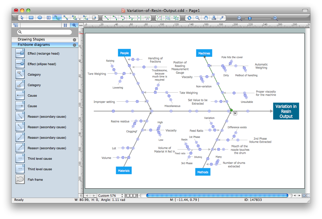
Picture: Cause and Effect Diagrams
Related Solution:
Tennessee is a U.S. state located in the Southeastern United States.
The vector stencils library Tennesse contains contours for ConceptDraw DIAGRAM diagramming and vector drawing software. This library is contained in the Continent Maps solution from Maps area of ConceptDraw Solution Park.
Picture: Geo Map — USA — Tennesse
Related Solution:
The vector stencils library United Kingdom contains contours for ConceptDraw DIAGRAM diagramming and vector drawing software. This library is contained in the Continent Maps solution from Maps area of ConceptDraw Solution Park.
Picture: Geo Map - Europe - United Kingdom
Related Solution:
It is impossible to imagine modern life and science without maps, they surround us anywhere, they are used in geography, history, politics, economics, and many other fields of science. ConceptDraw DIAGRAM diagramming and vector drawing software offers the USA Maps Solution from the Maps Area of ConceptDraw Solution Park with its collection of samples and libraries for easy drawing the Map of USA.
Picture: Map of USA
Related Solution:


