
Example 1. Map of USA - Counties of Pennsylvania
Collection of predesigned objects included in USA Maps Solution is enormous. These are 52 vector objects of USA states grouped in 9 libraries:
- East North Central States
- East South Central States
- Mid-Atlantic States
- Mountain States
- New England States
- Pacific States
- South Atlantic States
- Mid-West North States
- Mid-West South States

Example 2. USA Maps Solution in ConceptDraw STORE
Now for designing professional looking USA Maps you need follow only few steps:
- create new document,
- drag the needed objects from the libraries of USA Maps Solution,
- apply colors to make your own map colorful and successful.
Another way is to use as the base ready U.S. States Map template also included in USA Maps solution.

Example 3. U.S. States Map Template
The sample and template for drawing Map of USA you see on this page were created in ConceptDraw DIAGRAM software using the USA Maps solution for ConceptDraw Solution Park. They are included in USA Maps solution and available from ConceptDraw STORE.
Use the USA Maps solution for ConceptDraw DIAGRAM software to create your own USA Maps, US map with cities, USA map with capitals quick, easy and effective.
All source documents are vector graphic documents. They are available for reviewing, modifying, or converting to a variety of formats (PDF file, MS PowerPoint, MS Visio, and many other graphic formats) from the ConceptDraw STORE. The USA Maps Solution is available for all ConceptDraw DIAGRAM or later users.
TEN RELATED HOW TO's:
A continent is a large area of land washed by the seas. There are 7 continents on the Earth: Asia, Africa, North America, South America, Antarctica, Europe, and Australia. If you want create the 7 Continents Map, we offer you incredibly useful tool for this - ConceptDraw DIAGRAM diagramming and vector drawing software extended with Continent Maps Solution from the Maps Area of ConceptDraw Solution Park.
Picture: 7 Continents Map
Related Solution:
ConceptDraw defines some map types, divided into three categories. Every map type has specific shapes and examples.
Picture: Types of Map - Overview
Related Solution:
Guyana, officially the Co-operative Republic of Guyana, is a sovereign state on the northern coast of South America.
The vector stencils library Guyana contains contours for ConceptDraw DIAGRAM diagramming and vector drawing software. This library is contained in the Continent Maps solution from Maps area of ConceptDraw Solution Park.
Picture: Geo Map - South America - Guyana
Related Solution:
ConceptDraw DIAGRAM diagramming and vector drawing software extended with Electrical Engineering Solution from the Industrial Engineering Area of ConceptDraw Solution Park affords you the easiest and fastest way for designing professional looking Electrical Schematics.
Picture: Electrical Schematics
Related Solution:
The HR Management Software is an incredibly powerful tool for those who need to analyze or present human resource process flows in a visually effective manner.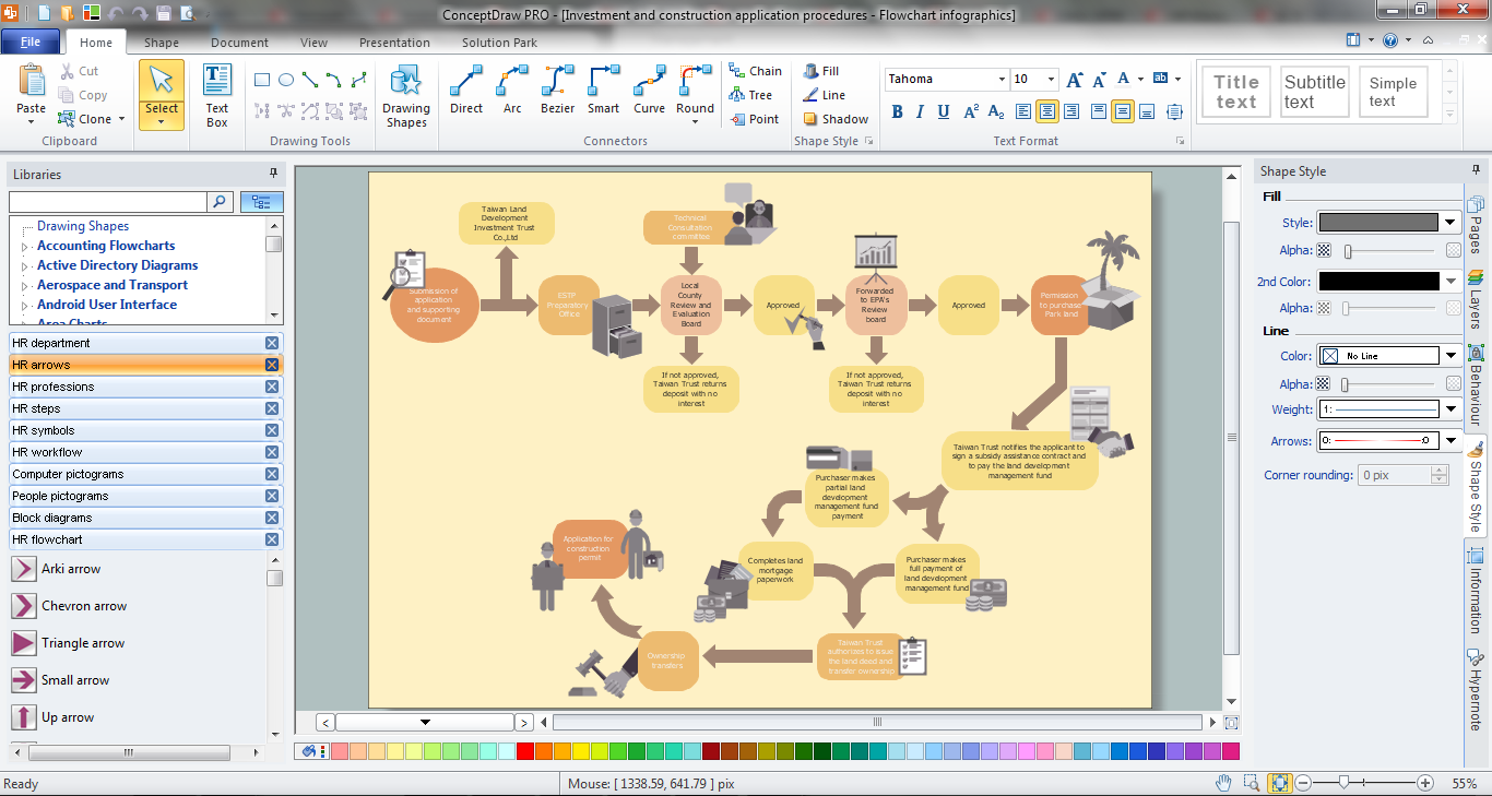
Picture: HR Management Software
Related Solution:
Nature solution expands this software possibilities to create beautiful illustrations diagrams with the new library which contains 17 vector objects.
Picture: Nature Drawings - How to Draw
It's no secret that there is a list of skills that every average system administrator should have. And it's important to be able to manage domains via active directory technologies. The best way to keep all the details in mind is to draw a diagram representing users, groups and domains.
This diagram represents an Active Directory Services (Active Directory Domain Services). It can be helpful for system and network administrators to organize a network physical and logical elements (domains, data bases, servers, network equipment, end-user computers etc.) into a secure and logical structure. The logical structure of Active Directory is a hierarchical organization of all network components. The data that is stored in Active Directory comes from some diverse sources. The Active Directory diagram created using ConceptDraw Active Directory Diagram solution. It shows allocating group policies and functions assigned to end users. It helps to plan, manage and maintain the certain user access scenario.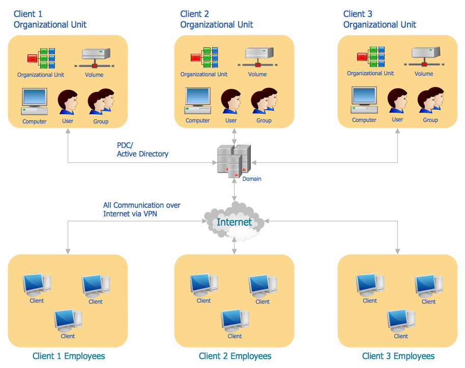
Picture: Active Directory Diagram
Related Solution:
The most convenient, useful and right way for software engineers, UI designers, UI developers is to use UI patterns in the process of developing any application for computer devices. The User Interface (UI) patterns are standardized solutions for common design problems.
Picture: UI Patterns
Related Solution:
Bolivia, officially known as the Plurinational State of Bolivia, is a landlocked country located in central South America.
The vector stencils library Bolivia contains contours for ConceptDraw DIAGRAM diagramming and vector drawing software. This library is contained in the Continent Maps solution from Maps area of ConceptDraw Solution Park.
Picture: Geo Map - South America - Bolivia
Related Solution:
Nebraska is a state on the Great Plains of the Midwestern United States.
The vector stencils library Nebraska contains contours for ConceptDraw DIAGRAM diagramming and vector drawing software. This library is contained in the Continent Maps solution from Maps area of ConceptDraw Solution Park.
Picture: Geo Map — USA — Nebraska
Related Solution:

