Map of USA

 USA Maps
Use the USA Maps solution to create a map of USA, a US interstate map, printable US maps, US maps with cities and US maps with capitals. Create a complete USA states map.
USA Map States

USA Map

Geo Map — United States of America Map

Map of USA States

Export from ConceptDraw DIAGRAM Document to a Graphic File


Geo Map of Americas

Use this template of North America map with contours of North American countries, capitals and main cities to design your political or thematic map. This North America map template for the ConceptDraw PRO diagramming and vector drawing software is included in the Continent Maps solution from the Maps area of ConceptDraw Solution Park.
North America map template

Geo Map - World

Geo Mapping Software Examples - World Map Outline

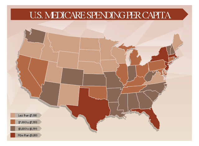
This healthcare economics infogram example was redesigned from the Wikimedia Commons file: Medicare spending per capita.png.
"Research by The Dartmouth Institute for Health Policy and Clinical Practice in the Dartmouth Atlas showed that in 2006, Medicare spending varied significantly by state. Other research quoted by the CEA Report indicated that up to 30% of Medicare costs could be saved if the middle- and high-cost states spent at the level of the lower-cost states.[1] Bear in mind that this is a Medicare comparison, so all the persons in the population analyzed are over 65.
References:
1. White House Council of Economic Advisors (CEA)-The Economic Case for Health Care Reform-June 2009-Page 19."
[commons.wikimedia.org/ wiki/ File:Medicare_ spending_ per_ capita.png]
The healthcare management thematic map sample "U.S. Medicare spending per capita" was created using the ConceptDraw PRO diagramming and vector drawing software extended with the Management Infographics solition from the area "Business Infographics" in ConceptDraw Solution Park.
Healthcare management infographics example
Use this template to design your North America political map, cartogram or thematic map, to visualize your spatial business information connected with geographic areas, locations or ways.
This North America map template for the ConceptDraw PRO diagramming and vector drawing software is included in the Continent Maps solution from the Maps area of ConceptDraw Solution Park.
This North America map template for the ConceptDraw PRO diagramming and vector drawing software is included in the Continent Maps solution from the Maps area of ConceptDraw Solution Park.
North America thematic map template

HelpDesk
How to Draw a Map of USA States

- Australia Map Icon Png Outline Cities
- Geo Map — Asia | Geo Map - Oceania | USA Map | Middle East Map ...
- ConceptDraw Solution Park | USA Maps | Website Wireframe | Free ...
- ConceptDraw Solution Park | Network Security Diagrams | USA ...
- Ice Hockey Rink Dimensions | USA Maps | Continent Maps | North ...
- iPhone User Interface | Health Food | USA Maps | News Title Bar Png
- USA Maps | Nature | Pictogram Lakes Colour In Png Format
- Aerospace and Transport | Manufacturing and Maintenance | USA ...
- Argentina Map Outline Png
- USA Maps | Design elements - Geography | Geo Map - Europe ...
- USA Maps | Geo Map — USA — Virginia | Geo Map - USA ...
- Map Of Us Png
- Travelling Icon Png
- Banner Png Free Download
- Benefit Corporation legislation - Thematic map | USA Map | Map of ...
- Asean Countries Map Png
- Percentages of the U.S. population by race | Pie Charts | Pyramid ...
- United States of America - Vector stencils library | United States of ...
- Geo Map - Europe | Flags - Stencils library | Pie Charts | Us Eu Png
- Usa Map Template