This healthcare economics infogram example was redesigned from the Wikimedia Commons file: Medicare spending per capita.png.
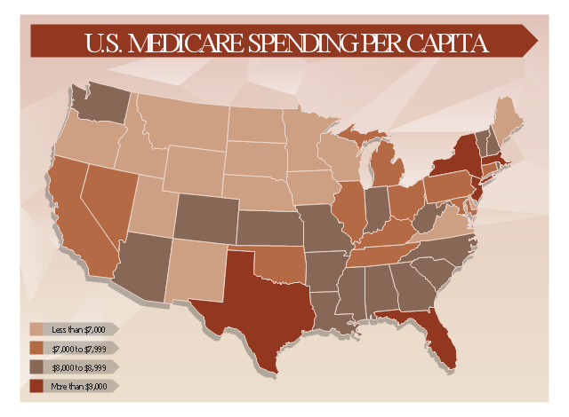
"Research by The Dartmouth Institute for Health Policy and Clinical Practice in the Dartmouth Atlas showed that in 2006, Medicare spending varied significantly by state. Other research quoted by the CEA Report indicated that up to 30% of Medicare costs could be saved if the middle- and high-cost states spent at the level of the lower-cost states.[1] Bear in mind that this is a Medicare comparison, so all the persons in the population analyzed are over 65.
References:
1. White House Council of Economic Advisors (CEA)-The Economic Case for Health Care Reform-June 2009-Page 19."
[commons.wikimedia.org/ wiki/ File:Medicare_ spending_ per_ capita.png]
The healthcare management thematic map sample "U.S. Medicare spending per capita" was created using the ConceptDraw PRO diagramming and vector drawing software extended with the Management Infographics solition from the area "Business Infographics" in ConceptDraw Solution Park.
Healthcare management infographics example
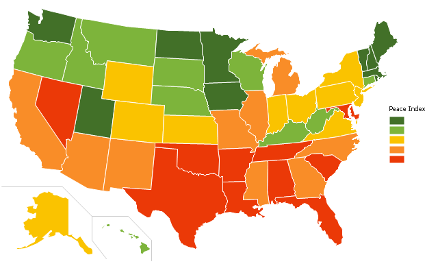
"The United States Peace Index (USPI) is a measurement of American States and cities by their peacefulness. Created by the Institute for Economics and Peace, the creators of the Global Peace Index, it is said to be the first in a series of National sub-divisions by their peacefulness." [United States Peace Index. Wikipedia]
This thematic map example was redesigned from the Wikimedia Commons file: 2011 USPI map.png.
[commons.wikimedia.org/ wiki/ File:2011_ USPI_ map.png]
This file is licensed under the Creative Commons Attribution 3.0 Unported license. [creativecommons.org/ licenses/ by/ 3.0/ deed.en]
The thematic map example "Ranks US states by peacefulness" was created using the ConceptDraw PRO diagramming and vector drawing software extended with the Continent Map solution from the Maps area of ConceptDraw Solution Park.
Thematic map - USA
Geo Map — Europe

Geo Map - Europe - Bulgaria

Geo Map - Asia - Papua New Guinea

Export from ConceptDraw DIAGRAM Document to a Graphic File


Geo Map — United States of America Map

"The Middle East (also called Mid East in US usage) is a region that roughly encompasses a majority of Western Asia (excluding the Caucasus) and Egypt. The term is used as a synonym for Near East, in opposition to Far East. The corresponding adjective is Middle Eastern and the derived noun is Middle Easterner. Arabs, Persians, and Turks constitute the largest ethnic groups in the region by population, while Kurds, Azeris, Copts, Jews, Assyrians, Maronites, Circassians, Somalis, Armenians, Druze and other denominations form a significant minority. ... The following countries are included within the Middle East... : Bahrain, Cyprus, Egypt, Iran, Iraq, Israel, Jordan, Kuwait, Lebanon, Northern Cyprus, Oman, Palestine, Qatar, Saudi Arabia, Syria, Turkey, United Arab Emirates, Yemen.
" [Middle East. Wikipedia]
This political map sample was redesigned from the Wikimedia Commons file: Middle east map.png. [commons.wikimedia.org/ wiki/ File:Middle_ east_ map.png]
The example "Middle East - Political map" was created using the ConceptDraw PRO diagramming and vector drawing software extended with the Continent Maps solution from the Maps area of ConceptDraw Solution Park.
Political map - Middle East

 USA Maps
Use the USA Maps solution to create a map of USA, a US interstate map, printable US maps, US maps with cities and US maps with capitals. Create a complete USA states map.
Map of USA

HelpDesk
How to Connect an Image to a Topic in Your Mind Map

Geo Map — USA — Wisconsin

USA Map

Map of USA States

- USA Maps | UK Map | Australia Map | Architectural North Arrow Png
- Geo Map - Europe | Design elements - Geography | Geo Map - USA ...
- Png River Image
- Outstanding trends of wastewater treatment plants | United States ...
- U.S. Medicare spending per capita | Graphic User Interface | How To ...
- Political map of Central America
- Map Of Us States
- Detailed Map Of Us States
- Middle East Flags Png
- Map symbols - Vector stencils library | How to Draw a Map of North ...
- How To Do A Mind Map In PowerPoint | Ribbon interface - Vector ...
- Ranks US states by peacefulness | Geo Map - United States of ...
- Geo Map of Americas | Geo Map - United States of America Map ...
- North and Central America flags - Stencils library | Geo Map - South ...
- Geo Map - USA - North Carolina | North America - Vector stencils ...
- Geo Map - United States of America Map | How to Draw Maps of ...
- Geo Map - United States of America Map | Learn how to create a ...
- Geo Map of Americas | Geo Map - South America - Suriname ...
- Geo Map - United States of America Map | North America map with ...
- Geo Map - Africa - Tanzania | East Africa - Political map | Africa flags ...