The vector stencils library "3D directional maps" contains 40 symbols for creating pictorial maps, street maps, locator maps, transit maps, tourist maps with points of interest (POI), road maps and route maps using the ConceptDraw PRO diagramming and vector drawing software.
"Pictorial maps are a category of maps that are also loosely called illustrated maps, panoramic maps, perspective maps, bird’s-eye view maps and Geopictorial maps amongst others. In contrast to the regular road map, Atlas or topographic cartography, pictorial maps depict a given territory with a more artistic rather than technical style. The cartography can be a sophisticated 3-D perspective landscape or a simple map graphic enlivened with illustrations of buildings, people and animals. They can feature all sorts of varied topics like historical events, legendary figures or local agricultural products and cover anything from an entire continent to a college campus. ...
Pictorial maps usually show an area as if viewed from above at an oblique angle. They are not generally drawn to scale in order to show street patterns, individual buildings, and major landscape features in perspective. While regular maps focus on the accurate rendition of distances, pictorial maps enhance landmarks and often incorporate a complex interplay of different scales into one image in order to give the viewer a more familiar sense of recognition." [Pictorial maps. Wikipedia]
The design elements library "3D directional maps" is included in the Directional Maps solution from the Maps area of ConceptDraw Solution Park.
3D pictorial map symbols

Brilliant Examples of Infographics Map, Transport, Road

Watercraft - Design Elements

Spatial infographics Design Elements: Transport Map

"Road maps come in many shapes, sizes and scales. Small, single-page maps may be used to give an overview of a region's major routes and features. ...
Highway maps generally give an overview of major routes within a medium to large region ranging from a few dozen to a few thousand miles or kilometers.
Street maps usually cover an area of a few miles or kilometers (at most) within a single city or extended metropolitan area. City maps are generally a specialized form of street map." [Road map. Wikipedia]
This 3D pictorial road map example was created using the ConceptDraw PRO diagramming and vector drawing software extended with the Directional Maps solution from the Maps area of ConceptDraw Solution Park.
3D Directional map

How to draw Metro Map style infographics? Moscow, New York, Los Angeles, London

Road Transport - Design Elements

Nature Drawings - How to Draw

How to draw Metro Map style infographics? (Los Angeles)

Spatial infographics Design Elements: Location Map

Types of Map - Overview

How to draw Metro Map style infographics? (New York)

Tools to Create Your Own Infographics

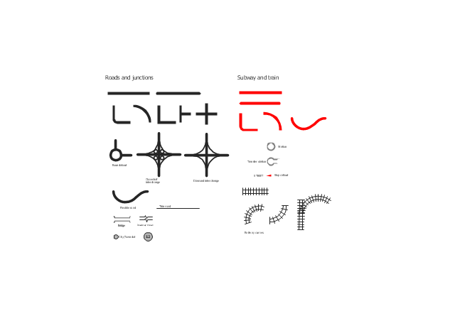
The vector stencils library "Roads and junctions" contains 38 symbols for creating the road and route maps, transit and directional maps, street and locator maps using the ConceptDraw PRO diagramming and vector drawing software.
The vector stencils library "Subway and train" contains 22 shapes for creating the transit maps of tube (metro) and railway.
"Road maps are perhaps the most widely used maps today, and form a subset of navigational maps, which also include aeronautical and nautical charts, railroad network maps, and hiking and bicycling maps." [Map. Wikipedia]
The example "Design elements - Roads and junctions, subway and train" is included in the Directional Maps solution from the Maps area of ConceptDraw Solution Park.
Road map stencils
Informative and Well-Designed Infographics

- Draw A Road Map With Transport Symbols
- 3D pictorial road map | Design elements - 3D directional maps | 3D ...
- Road Map Symbols
- 3D pictorial road map | How to draw Metro Map style infographics ...
- Road Map With Transport Symbols
- Road Transport - Design Elements | Types of Map - Overview ...
- Directional Maps | Design elements - 3D directional maps ...
- 3D pictorial street map | Design elements - 3D directional maps | 3D ...
- Brilliant Examples of Infographics Map , Transport, Road | Excellent ...
- Types of Map - Overview | Road Transport - Design Elements ...
- Road Transport - Design Elements | Watercraft - Design Elements ...
- Directional Maps | How to Create a Directional Map Using ...
- How To Create A Directional Roadmap
- Directional Maps | Maps | Map Directions | Road Maps
- 3D Directional map - Template | Directional Maps | Directions Maps ...
- Road Map Cartoon
- Road Transport - Design Elements | 3D Directional map - Template ...
- Directional Maps | 3D pictorial road map | Examples of Flowcharts ...
- Road Map Design
- Design elements - 3D directional maps | Directions Map | Directional ...