Map of UK — Isle of Man

Geo Map — USA — Illinois

Why People Select ConceptDraw MINDMAP

Australia Map — South Australia

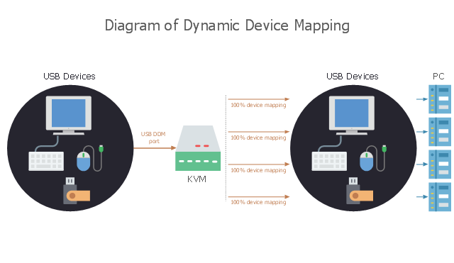
This computer diagram sample illustrates the dynamic device mapping. It was designed on the base of Wikimedia Commons file: DDM mapping.jpg.
[commons.wikimedia.org/ wiki/ File:DDM_ mapping.jpg]
This file is licensed under the Creative Commons Attribution-Share Alike 3.0 Unported license. [creativecommons.org/ licenses/ by-sa/ 3.0/ deed.en]
"Dynamic device mapping is a technology for USB KVM switches which is sometimes implemented as an alternative to standard USB keyboard and mouse emulation. ...
With DDM (Dynamic Device Mapping) Technology, the communication between shared peripherals and all connected systems are maintained 100% of the time, even as a user switches between the KVM ports. This makes generic device emulation unnecessary as the DDM allows each connected computer system to believe all connected I/ O devices are remaining connected even as the KVM switch might move to another port." [Dynamic device mapping. Wikipedia]
The computer diagram example "Dynamic device mapping" was created using the ConceptDraw PRO diagramming and vector drawing software extended with the Computers and Communications solution from the Illustration area of ConceptDraw Solution Park.
Computer diagram
Geo Map - Asia - Papua New Guinea

Standard Universal Audio & Video Connection Types

Flow Map: A Step-by-Step Guide

UML Composite Structure Diagram. Design Elements

Australia Map — Western Australia

Software Diagrams

 Computer Network Diagrams
Computer Network Diagrams solution extends ConceptDraw DIAGRAM software with samples, templates and libraries of vector icons and objects of computer network devices and network components to help you create professional-looking Computer Network Diagrams, to plan simple home networks and complex computer network configurations for large buildings, to represent their schemes in a comprehensible graphical view, to document computer networks configurations, to depict the interactions between network's components, the used protocols and topologies, to represent physical and logical network structures, to compare visually different topologies and to depict their combinations, to represent in details the network structure with help of schemes, to study and analyze the network configurations, to communicate effectively to engineers, stakeholders and end-users, to track network working and troubleshoot, if necessary.
Geo Map - South America - Haiti

Quick Recipes

Australia Map — New South Wales

Visual Presentations Made Easy with Diagramming Software


Map of UK — Channel Islands

 Cisco Networking
Cisco Networking solution extends the ConceptDraw DIAGRAM software functionality with properties of network diagramming and network modeling software. Solution provides the multifarious samples and large quantity of libraries with incredibly huge amount of complex predesigned vector design elements of standardized Cisco devices and equipment, such as CISCO servers, Cisco switches, Cisco Fabric Interconnects, Cisco Gateways, Access Servers, Cisco Optical NCS 1000, Cisco Optical NCS 2000, Cisco Optical NCS 4000, and Cisco Optical NCS 4200 devices, Cisco Physical Security, Cisco Service Exchange, Cisco Storage Networking, Cisco Unified Communications, Cisco Video, Cisco Wireless, and Cisco Application Networking Services equipment.
Map of Germany — Bremen

- Cisco Routers. Cisco icons, shapes, stencils and symbols | Geo Map
- Retract resistor check valve application | Design elements - Ports ...
- Dynamic device mapping | Computer network - Vector stencils ...
- Network Diagram Software LAN Network Diagrams & Diagrams for ...
- Design elements - Cisco switches and hubs | Computer network ...
- Building Drawing Design Element: Shipping and Receiving ...
- SysML | Design elements - Ports and Flows | Data Modeling ...
- Dynamic device mapping | Keyboard Shortcuts and Mouse Actions ...
- Network Layout Floor Plans | Network wiring cable. Computer and ...
- Rapid UML | Design elements - Ports and Flows | ATM UML ...