How to draw Metro Map style infographics? Moscow, New York, Los Angeles, London

"A transit map is a topological map in the form of a schematic diagram used to illustrate the routes and stations within a public transport system - whether this be bus lines, tramways, rapid transit, commuter rail or ferry routes. The main components are color coded lines to indicate each line or service, with named icons to indicate stations or stops. ...
There are a growing number of books, websites and works of art on the subject of urban rail and metro map design and use. There are now hundreds of examples of diagrams in an urban rail or metro map style that are used to represent everything from other transit networks like buses and national rail services to sewerage systems and Derbyshire public houses." [Transit map. Wikipedia]
The transportation map template for the ConceptDraw PRO diagramming and vector drawing software is included in the Spatial Infographics solution from the area "What is Infographics" of ConceptDraw Solution Park.
Transit map

Subway Train Map

How to draw Metro Map style infographics? (Los Angeles)

How to draw Metro Map style infographics? (New York)

Infographic design elements, software tools Subway and Metro style

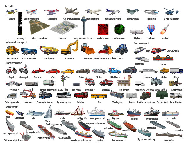
Rail transport - Design elements

Directions Map

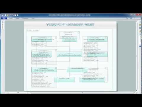
UML Composite Structure Diagram

Map Infographic Design

 Metro Map
Metro Map solution extends ConceptDraw PRO software with templates, samples and library of vector stencils for drawing the metro maps, route maps, bus and other transport schemes, or design tube-style infographics.
"A transit map is a topological map in the form of a schematic diagram used to illustrate the routes and stations within a public transport system - whether this be bus lines, tramways, rapid transit, commuter rail or ferry routes. The main components are color coded lines to indicate each line or service, with named icons to indicate stations or stops.
Transit maps can be found in the transit vehicles, at the platforms or in printed timetables. Their primary function is to help users to efficiently use the public transport system, including which stations function as interchange between lines. Unlike conventional maps, transit maps are usually not geographically accurate - instead they use straight lines and fixed angles, and often illustrate a fixed distance between stations, compressing those in the outer area of the system and expanding those close to the center." [Transit map. Wikipedia]
This transit map template for the ConceptDraw PRO diagramming and vector drawing software is included in the Metro Map solution from the Maps area of ConceptDraw Solution Park.
www.conceptdraw.com/ solution-park/ maps-metro-map
Transit map

 Metro Map
Metro Map solution extends ConceptDraw PRO software with templates, samples and library of vector stencils for drawing the metro maps, route maps, bus and other transport schemes, or design tube-style infographics.
Transportation Infographics

The illustration template "Transport" contains vector clipart of transportation vehicles, office buildings and ancillary facilities.
"Transport or transportation is the movement of people, animals and goods from one location to another. Modes of transport include air, rail, road, water, cable, pipeline and space. The field can be divided into infrastructure, vehicles and operations. Transport is important because it enables trade between people, which is essential for the development of civilizations. Transport infrastructure consists of the fixed installations including roads, railways, airways, waterways, canals and pipelines and terminals such as airports, railway stations, bus stations, warehouses, trucking terminals, refueling depots (including fueling docks and fuel stations) and seaports. Terminals may be used both for interchange of passengers and cargo and for maintenance. Vehicles traveling on these networks may include automobiles, bicycles, buses, trains, trucks, people, helicopters and aircraft." [Transport. Wikipedia]
The illustration template "Transport" for the ConceptDraw PRO diagramming and vector drawing software is included in the Aerospace and Transport solution from the Illustration area of ConceptDraw Solution Park.
Vector clip art - Illustration template
- Transport map - Template | Transit map template | Metro Maps ...
- Transit map template | Transport map - Template | Metro Map ...
- Los Angeles county Metro Rail map | How to draw Metro Map style ...
- Metro Map | Transport map - Template | Subway Train Map ...
- Transport map - Template | Intelligent transportation system | How to ...
- Transit map template | Metro Map | Maps | Transit Maps
- Subway Train Map | How to draw Metro Map style infographics ...
- Spatial infographics Design Elements: Transport Map | Metro Map ...
- Transport map - Template | How to draw Metro Map style ...
- Transport map - Template | Metro Map | Metro map - Northern line ...
- Transport map - Template | Chronology of social networks ...
- Rail transport - Design elements | UML Class Diagram Example for ...
- How to draw Metro Map style infographics? (Los Angeles) | Rail ...
- Subway Train Map | Metro Train Map | Rail transport - Design ...
- Metro Map | How to draw Metro Map style infographics? (Los ...
- Metro Train Map
- How to draw Metro Map style infographics? Moscow, New York, Los ...
- Cross-Functional Process Map Template | How to draw Metro Map ...
- How to draw Metro Map style infographics? (New York) | Transport ...