Infographic design elements, software tools Subway and Metro style

The vector stencils library "Transport map" contains 96 pictograms for drawing transport maps.
Use it in your spatial infographics for visual representation of transport schemes and plans as metro maps in the ConceptDraw PRO diagramming and vector drawing software extended with the Spatial Infographics solution from the area "What is Infographics" of ConceptDraw Solution Park.
Use it in your spatial infographics for visual representation of transport schemes and plans as metro maps in the ConceptDraw PRO diagramming and vector drawing software extended with the Spatial Infographics solution from the area "What is Infographics" of ConceptDraw Solution Park.
Train Railway

Bus Stop

Tramlink

Marina/Ferry Dock

Information Center

Information Center

Airport

Airport

Underground/Subway/Metro

Underground/Subway/Metro

National Rail Train Station

Taxi

Taxi

Parking

Parking

Parking

Parking

Bicycle Parking

Bicycle Parking

Fuel/Gas/Petrol

Fuel/Gas/Petrol

Police

Police

Hospital

Hospital

Wheelchair Access

Wheelchair Access

First Aid

First Aid

Telephone

Telephone

Post Office

Post Office

Landmarks and Museums

Landmarks and Museums

University

University

Shopping/Supermarket

Shopping/Supermarket

Cafe

Cafe

Food and Drinks

Food and Drinks

Man

Woman

Restrooms/Toilets

Restrooms/Toilets

Park

Park

Zoo

Zoo

Hotel

Hotel

Camping

Camping

City

Skyscraper

Building

Ocean

Straight River

Flexible River

Bridge

North Arrow
Viewpoint

Scale

Road line

Road rounded line

Road corner

Road curve 1

Road curve 2

Crossroads

Roundabout

Cloverleaf interchange

Roadway break

Railway line

Railway curve

Railway fork

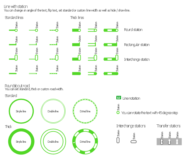
Standard line with standard station - basic road

Thick line with standard station - basic road

Standard line with rectangular station - basic road

Thick line with rectangular station - basic road

Standard line with standard station - double road

Thick line with standard station - double road

Standard line with rectangular station - double road

Thick line with rectangular station - double road

Standard line with standard station - dotted road

Thick line with standard station - dotted road

Standard line with rectangular station - dotted road

Thick line with rectangular station - dotted road

Interchange Station Vertical

Interchange Station Horizontal

Transfer Station 1

Transfer Station 2

Transfer Station 3

Line Notation

Street direction

How to draw Metro Map style infographics? (London)

 Metro Map
Metro Map solution extends ConceptDraw PRO software with templates, samples and library of vector stencils for drawing the metro maps, route maps, bus and other transport schemes, or design tube-style infographics.
 ConceptDraw Solution Park
ConceptDraw Solution Park collects graphic extensions, examples and learning materials
Infographic software: the sample of New York City Subway map

Metro Map

The Metro Map Solution from the Maps Area uses two ConceptDraw techniques: Replicating Objects and Switching Objects. And the result is a vector graphic document.
The vector stencils library "Transport maps" contains 34 shapes for designing the transportation maps, metro maps, subway maps, underground maps, tube maps using the ConceptDraw PRO diagramming and vector drawing software extended with the Metro Map solution from the Maps area of ConceptDraw Solution Park.
Metro map shapes
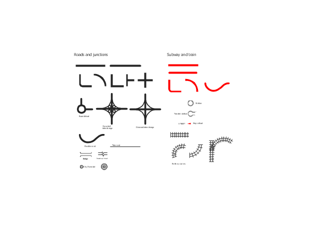
The vector stencils library "Roads and junctions" contains 38 symbols for creating the road and route maps, transit and directional maps, street and locator maps using the ConceptDraw PRO diagramming and vector drawing software.
The vector stencils library "Subway and train" contains 22 shapes for creating the transit maps of tube (metro) and railway.
"Road maps are perhaps the most widely used maps today, and form a subset of navigational maps, which also include aeronautical and nautical charts, railroad network maps, and hiking and bicycling maps." [Map. Wikipedia]
The example "Design elements - Roads and junctions, subway and train" is included in the Directional Maps solution from the Maps area of ConceptDraw Solution Park.
Road map stencils
Excellent Examples of Infographic Maps

The vector stencils library "Landmarks" contains 69 landmark symbols of buildings, waterways, scale and directional indicators for labeling transportation and directional maps, road and route maps, street and transit maps, locator and tourist maps.
The pictograms example "Landmarks - Vector stencils library" was created using the ConceptDraw PRO diagramming and vector drawing software extended with the Directional Maps solution from the Maps area of ConceptDraw Solution Park.
The pictograms example "Landmarks - Vector stencils library" was created using the ConceptDraw PRO diagramming and vector drawing software extended with the Directional Maps solution from the Maps area of ConceptDraw Solution Park.
Viewpoint

North arrow
North arrow
Building

Building

Town house

Suburban home

Skyscraper

Town hall

Public house

Petrol station

Gas station

Factory

School

Warehouse

Hospital

Fire station

Train station

Condos

Barn

Motel

Convenience store

Shopping centre

City

Church

Cathedral

National tail train station

Train railway

Bus stop

Tramlink

Marina / Ferry dock

Car ferry

Stop light

Airport

Airport

Underground / Subway / Metro

Taxi

Bicycle parking

Parking

Fuel / Gas / Petrol

Police

Hospital

Wheelchair access

First aid

Telephone

Post office

Landmarks and museums

University

Shopping

Refreshments / Public House

Restrooms / Toilets

Park

Zoo

Information center

Stadium 1

Stadium 2

Park

Tree

Fir-tree

Ocean

Lake

River

Angled river

Forked river

Curved river

Curved river

Flexible river

Bridge

Scale

 Continent Maps
Continent Maps solution extends ConceptDraw PRO software with templates, samples and libraries of vector stencils for drawing the thematic maps of continents, state maps of USA and Australia.
Spatial Infographics

 Directional Maps
Directional Maps solution extends ConceptDraw PRO software with templates, samples and libraries of vector stencils for drawing the directional, location, site, transit, road and route maps, plans and schemes.
The vector stencils library "Transport map" contains 96 pictograms for drawing transport maps.
Use it in your spatial infographics for visual representation of transport schemes and plans as metro maps in the ConceptDraw PRO diagramming and vector drawing software extended with the Spatial Infographics solution from the area "What is Infographics" of ConceptDraw Solution Park.
Use it in your spatial infographics for visual representation of transport schemes and plans as metro maps in the ConceptDraw PRO diagramming and vector drawing software extended with the Spatial Infographics solution from the area "What is Infographics" of ConceptDraw Solution Park.
Train Railway
Bus Stop
Tramlink
Marina/Ferry Dock
Information Center
Information Center
Airport
Airport
Underground/Subway/Metro
Underground/Subway/Metro
National Rail Train Station
Taxi
Taxi
Parking
Parking
Parking
Parking
Bicycle Parking
Bicycle Parking
Fuel/Gas/Petrol
Fuel/Gas/Petrol
Police
Police
Hospital
Hospital
Wheelchair Access
Wheelchair Access
First Aid
First Aid
Telephone
Telephone
Post Office
Post Office
Landmarks and Museums
Landmarks and Museums
University
University
Shopping/Supermarket
Shopping/Supermarket
Cafe
Cafe
Food and Drinks
Food and Drinks
Man
Woman
Restrooms/Toilets
Restrooms/Toilets
Park
Park
Zoo
Zoo
Hotel
Hotel
Camping
Camping
City
Skyscraper
Building
Ocean
Straight River
Flexible River
Bridge
North Arrow
Viewpoint
Scale
Road line
Road rounded line
Road corner
Road curve 1
Road curve 2
Crossroads
Roundabout
Cloverleaf interchange
Roadway break
Railway line
Railway curve
Railway fork
Standard line with standard station - basic road
Thick line with standard station - basic road
Standard line with rectangular station - basic road
Thick line with rectangular station - basic road
Standard line with standard station - double road
Thick line with standard station - double road
Standard line with rectangular station - double road
Thick line with rectangular station - double road
Standard line with standard station - dotted road
Thick line with standard station - dotted road
Standard line with rectangular station - dotted road
Thick line with rectangular station - dotted road
Interchange Station Vertical
Interchange Station Horizontal
Transfer Station 1
Transfer Station 2
Transfer Station 3
Line Notation
Street direction
 Maps Area
Solutions from the Maps Area of ConceptDraw Solution Park collect templates, samples and libraries of vector stencils for drawing geographical, directional and transport maps.
HelpDesk
How to Draw a Map of North America Using ConceptDraw PRO

Geo Map - Asia - Philippines

Use the Continent Maps solution and Philippines library to draw thematic maps, geospatial infographics and vector illustrations. This solution to help visualize the business and thematic information connected with geographic areas, locations or customs; for your business documents, presentations and websites.
- Infographic design elements, software tools Subway and Metro style ...
- Infographic design elements, software tools Subway and Metro style ...
- How to draw Metro Map style infographics? (London) | Infographic ...
- Metro Map | How to draw Metro Map style infographics? (New York ...
- Infographic design elements, software tools Subway and Metro style ...
- Concept Maps | Concept maps with ConceptDraw PRO | Simple ...
- SWOT Analysis | Metro Map | How to draw Metro Map style ...
- Universal Diagramming Area | Metro Map | Computer and Networks ...
- ConceptDraw Solution Park | Value Stream Mapping | Metro Map ...
- Metro Map | Los Angeles county Metro Rail map | How to draw Metro ...
- ConceptDraw Solution Park | Aerospace and Transport | Metro Map ...
- How to draw Metro Map style infographics? Moscow, New York, Los ...
- Infographic design elements, software tools Subway and Metro style ...
- How To Do A Mind Map In PowerPoint | Metro Map | SWOT Analysis ...
- How to draw Metro Map style infographics? (London) | Metro Map ...
- Event-driven Process Chain Diagrams EPC | Fishbone Diagram ...
- Value Stream Mapping | How to draw Metro Map style infographics ...
- How to draw Metro Map style infographics? Moscow, New York, Los
- How to draw Metro Map style infographics? (London) | How to draw ...
- Metro Map | Best Value Stream Mapping mac Software | Subway ...