Geo Map - Asia - Papua New Guinea

Export from ConceptDraw DIAGRAM Document to a Graphic File


 Gym and Spa Area Plans
Gym and Spa Area Plans solution extends abilities of the architects, designers, engineers, builders, marketing experts, gym instructors, fitness trainers, health and beauty services specialists. It is a real finding for all them due to the unique functionally thought-out drawing tools, samples and examples, template and libraries of pre-made vector design elements offered to help create the Gym and Spa area plans, Fitness plans, Gym workout plan, Gym layout plan, Spa design plans, Gym floor plan and Spa floor plan with any degree of detailing.
Geo Map - Asia - Japan

Local area network (LAN). Computer and Network Examples
 diagram")

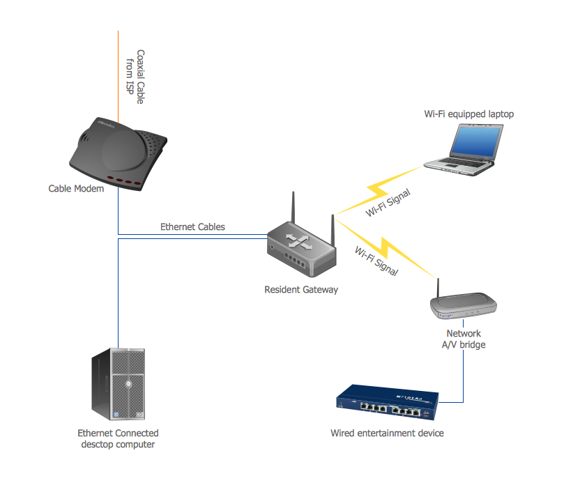
Home area networks (HAN). Computer and Network Examples
Geo Map - Europe - Bulgaria

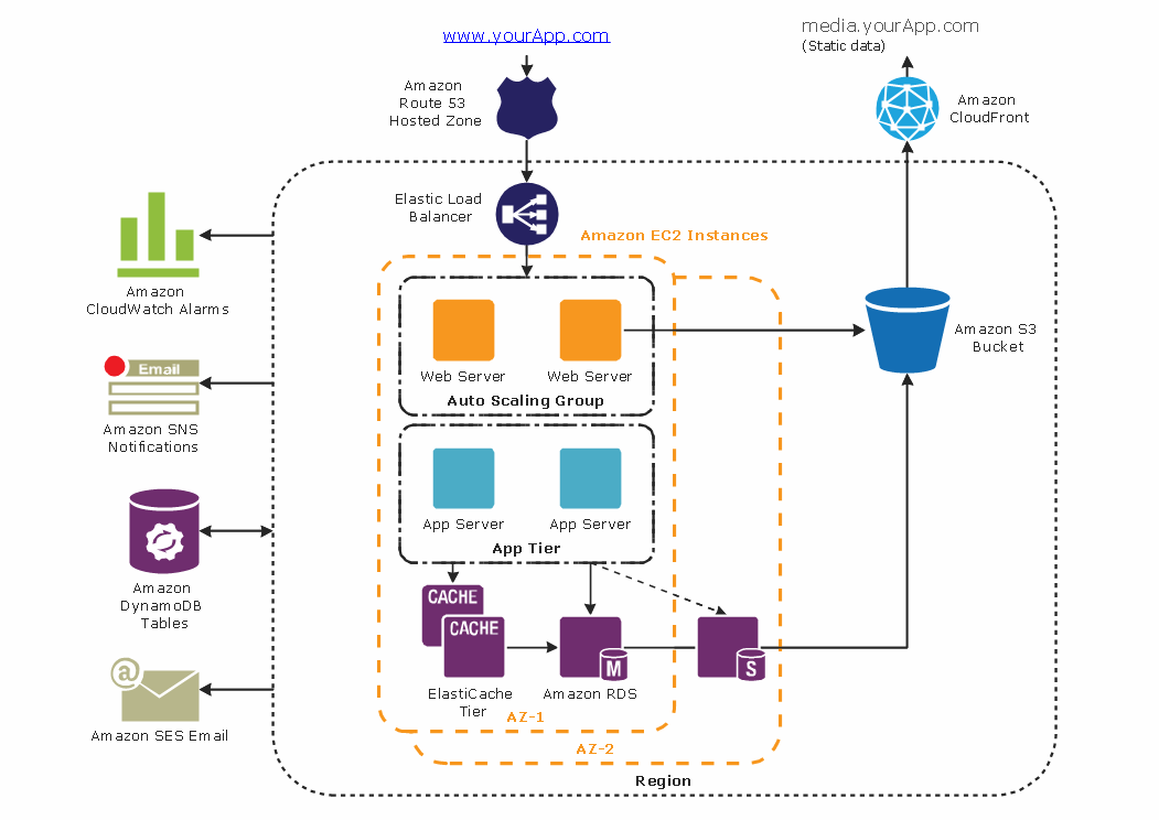
Diagramming tool - Amazon Web Services and Cloud Computing Diagrams
Geo Map — Europe

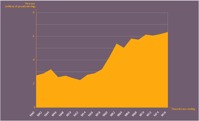
This area chart sample shows the revenue collected by the East India Company (after 1858 the British government) from salt (including inland and port taxes and sale of government salt). It was designed on the base of the Wikimedia Commons file: British India salt revenue 1840-1877.png.
[commons.wikimedia.org/ wiki/ File:British_ India_ salt_ revenue_ 1840-1877.png]
This file is licensed under the Creative Commons Attribution-Share Alike 3.0 Unported license. [creativecommons.org/ licenses/ by-sa/ 3.0/ deed.en]
"The Inland Customs Line which incorporated the Great Hedge of India (or Indian Salt Hedge[1]) was a customs barrier built by the British across India primarily to collect the salt tax. The customs line was begun while India was under the control of the East India Company but continued into the period of direct British rule. The line had its beginnings in a series of customs houses that were established in Bengal in 1803 to prevent the smuggling of salt to avoid the tax. These customs houses were eventually formed into a continuous barrier that was brought under the control of the Inland Customs Department in 1843." [Inland Customs Line. Wikipedia]
The area graph example "British India salt revenue 1840-1877" was created using the ConceptDraw PRO diagramming and vector drawing software extended with the Area Charts solution from the Graphs and Charts area of ConceptDraw Solution Park.
Area chart
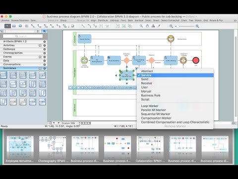
Flowchart design. Flowchart symbols, shapes, stencils and icons

Geo Map — Asia — Indonesia

Pyramid Diagram

Bar Diagrams for Problem Solving. Create economics and financial bar charts with Bar Graphs Solution
- Metropolitan area networks (MAN). Computer and Network ...
- Local Area Network Png
- Gym and Spa Area Plans | Gym Layout | Fitness Plans | Gym Room ...
- Local area network (LAN). Computer and Network Examples | How ...
- Object-Oriented Design | Basic Area Charts | Star Network Topology ...
- Local area network (LAN). Computer and Network Examples | Kid ...
- Basketball Area Png
- Firewall between LAN and WAN | Home area networks (HAN ...
- Gym and Spa Area Plans | Floor Plans | Sofas and chairs - Vector ...
- Firewall between LAN and WAN | Metropolitan area networks (MAN ...
- Local area network (LAN). Computer and Network Examples ...
- Local area network (LAN). Computer and Network Examples ...
- VoD architecture in a NVR enviroment | Local network area ...
- Bathroom Elements Png
- Home area networks (HAN). Computer and Network Examples ...
- Cisco Network Templates | AWS | Storage area networks (SAN ...
- Playground Plan Png
- Campus Area Networks (CAN). Computer and Network Examples ...
- Restaurant Floor Plan Software | Gym and Spa Area Plans | Create ...
- Storage area networks (SAN). Computer and Network Examples ...