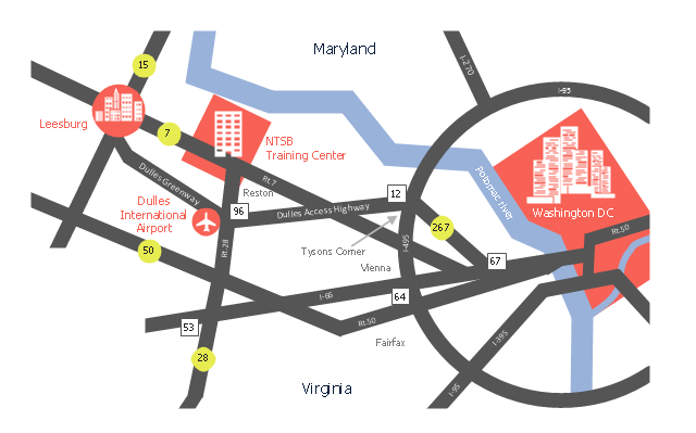
This location map sample was created on the base of the location map from the website of the NTSB Training Center.
"The NTSB Training Center is the training facility for the National Transportation Safety Board, an independent federal agency that investigates all civil aviation accidents in the United States and selected accidents in other modes of transportation.
The Training Center provides training for NTSB investigators and others from the transportation community to improve their practice of accident investigation techniques. The curriculum promotes independent, objective, and technically advanced accident investigations that will enhance the safety of all modes of transportation. ... Located on the Virginia campus of The George Washington University in Ashburn, the Training Center is ten miles from Washington Dulles Airport and 30 miles from Washington, D.C. Driving directions, maps, and a link to the virtual tour of our facility are available on the Campus page." [ntsb.gov/ trainingcenter/ about.htm]
The location map example "NTSB Training Center location" was created using the ConceptDraw PRO diagramming and vector drawing software extended with the Directional Maps solution from the Maps area of ConceptDraw Solution Park.
Location map
Geo Map - Asia - Philippines

Use the Continent Maps solution and Philippines library to draw thematic maps, geospatial infographics and vector illustrations. This solution to help visualize the business and thematic information connected with geographic areas, locations or customs; for your business documents, presentations and websites.
Geo Map - Europe - Macedonia

Geo Map - Africa - Ghana

The vector stencils library Ghana contains contours for ConceptDraw PRO diagramming and vector drawing software. This library is contained in the Continent Maps solution from Maps area of ConceptDraw Solution Park.
Geo Map - Asia - Turkey

The vector stencils library Turkey contains contours for ConceptDraw PRO diagramming and vector drawing software. This library is contained in the Continent Maps solution from Maps area of ConceptDraw Solution Park.
Geo Map - Europe - Spain

Geo Map - Africa - South Africa

The vector stencils library South Africa contains contours for ConceptDraw PRO diagramming and vector drawing software. This library is contained in the Continent Maps solution from Maps area of ConceptDraw Solution Park.
Geo Map - Asia - Iran

The vector stencils library Iran contains contours for ConceptDraw PRO diagramming and vector drawing software. This library is contained in the Continent Maps solution from Maps area of ConceptDraw Solution Park.
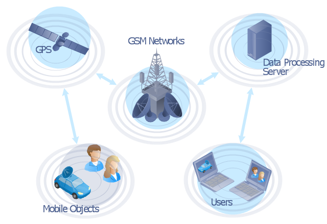
"The Global Positioning System (GPS) is a space-based satellite navigation system that provides location and time information in all weather conditions, anywhere on or near the Earth where there is an unobstructed line of sight to four or more GPS satellites. The system provides critical capabilities to military, civil and commercial users around the world. It is maintained by the United States government and is freely accessible to anyone with a GPS receiver." [Global Positioning System. Wikipedia]
This GPS operation diagram example was created using the ConceptDraw PRO diagramming and vector drawing software extended with the Telecommunication Network Diagrams solution from the Computer and Networks area of ConceptDraw Solution Park.
This GPS operation diagram example was created using the ConceptDraw PRO diagramming and vector drawing software extended with the Telecommunication Network Diagrams solution from the Computer and Networks area of ConceptDraw Solution Park.
GPS network diagram
Geo Map - Africa - Kenya

The vector stencils library Kenya contains contours for ConceptDraw PRO diagramming and vector drawing software. This library is contained in the Continent Maps solution from Maps area of ConceptDraw Solution Park.
Geo Map - Africa - Togo

The vector stencils library Togo contains contours for ConceptDraw PRO diagramming and vector drawing software. This library is contained in the Continent Maps solution from Maps area of ConceptDraw Solution Park.
Types of Map - Overview

Geo Map - Asia - Lebanon

The vector stencils library Lebanon contains contours for ConceptDraw PRO diagramming and vector drawing software. This library is contained in the Continent Maps solution from Maps area of ConceptDraw Solution Park.
Geo Map - South America - Paraguay

The vector stencils library Paraguay contains contours for ConceptDraw PRO diagramming and vector drawing software. This library is contained in the Continent Maps solution from Maps area of ConceptDraw Solution Park.
Geo Map - Europe - Montenegro

- Geo Map - USA - Washington | Geo Map - United States of America ...
- Geo Map - United States of America Map | Map of USA with state ...
- USA Maps | Geo Map - United States of America Map | Map of USA ...
- Geo Map - USA - Maryland | Geo Map - United States of America ...
- Geo Map - United States of America Map | Continent Maps | Map of ...
- Geo Map - United States of America Map | Geo Map - USA - Alaska ...
- The Map Of The United States Of America
- Geo Map - United States of America Map | Geo Map - USA - Alaska ...
- How To Draw Florida State
- Geo Map - USA - Missouri | Rolla USGS Center locator map | Geo ...
- Geo Map - United States of America Map | Continent Maps | Geo ...
- Europe - Thematic map template | European membership of the EU ...
- Geo Map - USA - Illinois | United States of America - Vector stencils ...
- Geo Map - United States of America Map
- Geo Map - USA - Washington | | | Washington
- Diagram Of The United States
- Design elements - Continental map | European membership of the ...
- Geo Map - Europe - Bulgaria | Geo Map - USA - Oregon | Geo Map ...
- United States Haiti Map
- Geo Map - United States of America Map