 Organizational Charts
Organizational Charts solution extends ConceptDraw PRO software with samples, templates and library of vector stencils for drawing the org charts.
 USA Maps
Use the USA Maps solution to create a map of USA, a US interstate map, printable US maps, US maps with cities and US maps with capitals. Create a complete USA states map.
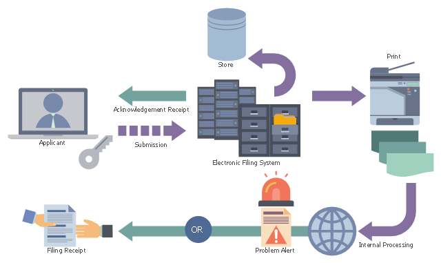
This example was designed on the base of the "Diagram of New Application Workflow" from the United States Patent and Trademark Office (USPTO) website. [uspto.gov/ images/ legalefs1.jpg]
"A nonprovisional application for a patent is made to the Director of the United States Patent and Trademark Office and includes:
(1) A written document which comprises a specification (description and claims);
(2) Drawings (when necessary);
(3) An oath or declaration; and
(4) Filing, search, and examination fees." [uspto.gov/ patents-getting-started/ general-information-concerning-patents#heading-12]
The diagram example "New application workflow" was created using ConceptDraw PRO software extended with the Business Process Workflow Diagrams solution from the Business Processes area of ConceptDraw Solution Park.
Business process flow diagram
HelpDesk
How to Draw a Map of USA States Using ConceptDraw PRO

 Target and Circular Diagrams
This solution extends ConceptDraw PRO software with samples, templates and library of design elements for drawing the Target and Circular Diagrams.
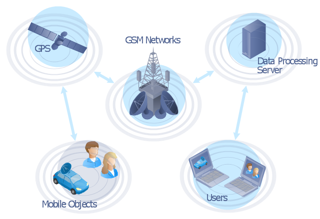
"The Global Positioning System (GPS) is a space-based satellite navigation system that provides location and time information in all weather conditions, anywhere on or near the Earth where there is an unobstructed line of sight to four or more GPS satellites. The system provides critical capabilities to military, civil and commercial users around the world. It is maintained by the United States government and is freely accessible to anyone with a GPS receiver." [Global Positioning System. Wikipedia]
This GPS operation diagram example was created using the ConceptDraw PRO diagramming and vector drawing software extended with the Telecommunication Network Diagrams solution from the Computer and Networks area of ConceptDraw Solution Park.
This GPS operation diagram example was created using the ConceptDraw PRO diagramming and vector drawing software extended with the Telecommunication Network Diagrams solution from the Computer and Networks area of ConceptDraw Solution Park.
GPS network diagram
- Usa Diagram
- The Diagram Of The United State
- Geo Map — United States of America Map | Australia Map | Network ...
- Defensive Strategy Diagram – 46 Defence | Geo Map - United States ...
- Process Flowchart | Organizational chart - United States Department ...
- Geo Map - United States of America Map | Learn how to create a ...
- Organizational chart - United States Department of Labor ...
- Geo Map — United States of America Map | Entity Relationship ...
- London election results | 2012 United States presidential election ...
- United States Map Diagram
- Geo Map - USA - Kansas | Geo Map - United States of America Map ...
- How to Create a Timeline Diagram in ConceptDraw PRO | Geo Map ...
- The Diagram Of Map Of United State
- CS Odessa Releases a Paid United States Mapping Solution for ...
- USA Maps | Geo Map - USA - Washington | 2012 United States ...
- Percentages of the U.S. population by race | Pie Charts | Pyramid ...
- USA Maps | Geo Map - United States of America Map | Basic ...
- Diagram Of North American Continent And Country On Its Map
- Diagram Of Usa States Map