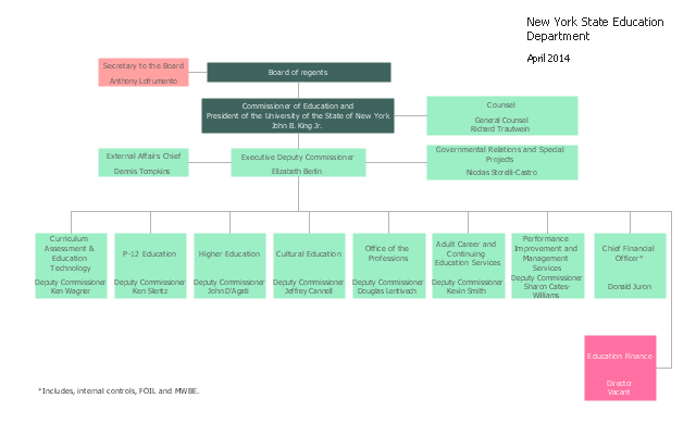
This organization chart sample was created on the base of the figure from the website of New York State Education Department (NYSED).
"The New York State Education Department is part of the University of the State of New York (USNY), one of the most complete, interconnected systems of educational services in the United States."
[oms.nysed.gov/ orgchart/ ]
The organizational chart example "New York State Education Department" was created using the ConceptDraw PRO diagramming and vector drawing software extended with the Organizational Charts solution from the Management area of ConceptDraw Solution Park.
Organizational chart
Geo Map - USA - New York

The vector stencils library New York contains contours for ConceptDraw PRO diagramming and vector drawing software. This library is contained in the Continent Maps solution from Maps area of ConceptDraw Solution Park.
Infographic software: the sample of New York City Subway map

How to draw Metro Map style infographics? Moscow, New York, Los Angeles, London

How to draw Metro Map style infographics? (New York)

New York Subway has a long history starting on October 27, 1904. Since the opening many agencies have provided schemes of the subway system. At present time are 34 lines in use. This page present New York City subway map construct with Metro Map Solution in Conceptdraw PRO software. This is a one-click tool to add stations to the map. It lets you control the direction in which you create new stations, change lengths, and add text labels and icons. It contains Lines, Stations, and Landmarks objects
Geo Map - USA - Vermont

The vector stencils library Vermont contains contours for ConceptDraw PRO diagramming and vector drawing software. This library is contained in the Continent Maps solution from Maps area of ConceptDraw Solution Park.
Draw Company Structure with Organization Charting Software

Draw Company Structure Diagram - get the detailed information about the company structure and hierarchy - who execute what tasks and who is in charge at this company. This information shows the reasoning and success of business and is indispensable for investors and financial institutions.
Geo Map - USA - Massachusetts

The vector stencils library Massachusetts contains contours for ConceptDraw PRO diagramming and vector drawing software. This library is contained in the Continent Maps solution from Maps area of ConceptDraw Solution Park.
How to draw Metro Map style infographics? (Los Angeles)

This is a one-click tool to add stations to the map. It lets you control the direction in which you create new stations, change lengths, and add text labels and icons. It contains Lines, Stations, and Landmarks objects.
Spatial infographics Design Elements: Location Map

Geo Map - USA - Montana

The vector stencils library Montana contains contours for ConceptDraw PRO diagramming and vector drawing software. This library is contained in the Continent Maps solution from Maps area of ConceptDraw Solution Park.
Geo Map - USA - New Mexico

The vector stencils library New Mexico contains contours for ConceptDraw PRO diagramming and vector drawing software. This library is contained in the Continent Maps solution from Maps area of ConceptDraw Solution Park.
Geo Map - USA - New Jersey

The vector stencils library New Jersey contains contours for ConceptDraw PRO diagramming and vector drawing software. This library is contained in the Continent Maps solution from Maps area of ConceptDraw Solution Park.
How to draw Metro Map style infographics? (London)

Organization Chart Software


- How to draw Metro Map style infographics? ( New York ...
- Vector Simple Drawing Of Long Island Ny
- Ny State Vector Image
- Infographic software: the sample of New York City Subway map ...
- How to draw Metro Map style infographics? Moscow, New York , Los ...
- How to draw Metro Map style infographics? ( New York ) | How to ...
- Organizational chart - New York State Education Department | Geo ...
- Geo Map - USA - New York | Draw Company Structure with ...
- How to draw Metro Map style infographics? Moscow, New York , Los ...
- Geo Map - USA - New York
- Metro Map | How to draw Metro Map style infographics? Moscow ...
- How to draw Metro Map style infographics? Moscow, New York , Los
- Metro Map | How to draw Metro Map style infographics? Moscow ...
- How to draw Metro Map style infographics? ( New York ) | Subway ...
- Education | How to Create Education Infographics | Organizational ...
- Metro Map | MTA Subway Map | Infographic software: the sample of ...
- Metro Map | How to draw Metro Map style infographics? Moscow ...
- Metro Map | How to draw Metro Map style infographics? Moscow ...
- Metro Map | How to draw Metro Map style infographics? Moscow ...
- How to Draw an Organization Chart | Organizational chart - New ...