The stencils library "Flags" contains 204 clipart images of state flags.
"There are two separate meanings for the term state flag in vexillology - the flag of the government of a sovereign state, and the flag of an individual subnational state, such as a U.S. state, or a Russian oblast. ...
A state flag is a variant of a national flag (or occasionally a completely different design) specifically designated and restricted by law or custom (theoretically or actually) to use by a country's government or its agencies. For this reason they are sometimes referred to as government flags. In many countries the state flag and the civil flag (as flown by the general public) are identical, but in other countries, notably those in Latin America, central Europe, and Scandinavia, the state flag is a more complex version of the national flag, often featuring the national coat of arms or some other emblem as part of the design. Scandinavian countries also use swallowtailed state flags, to further differentiate them from civil flags.
In addition, some countries have state ensigns, separate flags for use by non-military government ships such as guard vessels. For example, government ships in the United Kingdom fly the blue ensign." [State flag. Wikipedia]
The clip art example "Flags - Stencils library" was created using the ConceptDraw PRO diagramming and vector drawing software extended with the Continent Maps solution from the Maps area of ConceptDraw Solution Park.
www.conceptdraw.com/ solution-park/ maps-continent
European Union

United Nations
Afghanistan
Albania
Algeria
Andorra
Angola
Antigua and Barbuda
Argentina
Armenia
Australia
Austria
Azerbaijan
Bahamas
Bahrain
Bangladesh
Barbados
Belarus
Belgium
Belize
Benin
Bolivia
Bosnia and Herzegovina
Botswana
Brazil
Brunei
Bulgaria
Burkina Faso
Burma
Burundi
Cambodia
Cameroon
Canada
Cape Verde
Central African Republic
Chad

Chile
China
Colombia
Comoros
Congo
Congo
Costa Rica
C??te d'Ivoire
Croatia
Cuba
Cyprus

Czech Republic
Denmark
Djibouti
Dominica
Dominican Republic
Ecuador
England
Egypt

El Salvador
Equatorial Guinea
Eritrea
Estonia
France
Ethiopia
Finland
Gabon
Gambia
Georgia
Germany

Ghana
Greece

Greenland
Grenada
Guatemala
Guinea
Guinea-Bissau
Guyana
Haiti
Honduras
Hong Kong
Hungary
Iceland
India
Indonesia
Iran
Iraq

Ireland
Israel
Italy
Jamaica
Jordan
Japan
Kazakhstan
Kenya
Kiribati
North Korea
South Korea
Kosovo
Laos
Kuwait
Kyrgyzstan
Latvia

Lebanon
Lesotho
Liberia
Libya
Liechtenstein
Lithuania
Luxembourg
Macedonia
Madagascar
Malawi
Malaysia
Maldives
Mali
Malta
Marshall Islands
Mauritius
Mauritania
Mexico

Micronesia
Moldova
Monaco
Mongolia
Montenegro
Morocco
Mozambique
Namibia
Nauru
Nepal
Netherlands
New Zealand
Nicaragua
Niger
Nigeria
Norway
Oman
Pakistan
Palau
Palestine
Panama
Papua New Guinea
Paraguay
Peru
Philippines
Poland
Portugal
Puerto Rico
Qatar

Romania
Russia
Rwanda
St. Kitts and Nevis
St. Lucia
St. Pierre and Miquelon
St. Vincent and the Grenadines
Samoa
San Marino
S??o Tom?? and Pr??ncipe
Saudi Arabia
Scotland
Senegal
Serbia
Seychelles
Sierra Leone
Singapore
Slovakia
Slovenia
Solomon Islands
Somalia
South Africa

Spain
Sri Lanka
Sudan
South Sudan
Suriname
Swaziland
Sweden
Switzerland

Syria
Taiwan
Tajikistan
Tanzania
Thailand
Timor Leste

Togo
Tokelau
Tonga
Trinidad and Tobago
Tunisia
Turkey
Turkmenistan
Tuvalu
Uganda
Ukraine
United Arab Emirates

United Kingdom
United States
Uruguay
Uzbekistan
Vanuatu
Venezuela
Vietnam
Western Sahara
Yemen

Zambia
Zimbabwe
Geo Map - USA - California

Geo Map - Asia - Brunei

Geo Map - Europe - Slovenia

Geo Map — Africa — Tanzania

Geo Map - USA - Massachusetts

Geo Map - USA - Georgia

"The Andean States are a group of nations in South America that are defined by sharing a common geography (Andes mountain range) or culture such as the Quechua language and Andean cuisine which was primarily spread during the times of the Inca Empire, but also before and after it.
Politically speaking, Argentina and Chile are usually not considered part of the Andean States as they lack a strong native Andean heritage and are culturally more oriented towards Europe and they are not a members of the Andean Community of Nations (which Venezuela is in the process of leaving).
The Andes occupy the western part of South America, stretching through the following countries: Colombia, Venezuela, Ecuador, Peru, Bolivia, Argentina (not considered to be -geopolitically- an Andean State), Chile (not considered to be -geopolitically- an Andean State)." [Andean states. Wikipedia]
"Southern Cone (Spanish: Cono Sur, Portuguese: Cone Sul) is a geographic region composed of the southernmost areas of South America, south of and around the Tropic of Capricorn. Traditionally, it covers Argentina, Chile and Uruguay, bounded on the west by the Pacific Ocean, and south to the junction between the Pacific and Atlantic Oceans, which is the closest continental area of Antarctica (1000 km). In terms of social and political geography, the Southern Cone comprises Argentina, Chile, Paraguay, Uruguay, Southern Brazil and the Brazilian state of São Paulo.
High life expectancy, the highest Human Development Index of Latin America, high standard of living, significant participation in the global markets and the emerging economy of its members make the Southern Cone the most prosperous macro-region in South America." [Southern Cone. Wikipedia]
Eastern South America (Brazil). "Brazil Listeni/ brəˈzɪl/ (Portuguese: Brasil, IPA: [bɾaˈziw]), officially the Federative Republic of Brazil (Portuguese: República Federativa do Brasil, About this sound listen (help·info)), is the largest country in both South America and the Latin American region. It is the world's fifth largest country, both by geographical area and by population. It is the largest Portuguese-speaking country in the world, and the only one in the Americas. Bounded by the Atlantic Ocean on the east, Brazil has a coastline of 7,491 km (4,655 mi). It is bordered on the north by Venezuela, Guyana, Suriname and the French overseas region of French Guiana; on the northwest by Colombia; on the west by Bolivia and Peru; on the southwest by Argentina and Paraguay and on the south by Uruguay. Numerous archipelagos form part of Brazilian territory, such as Fernando de Noronha, Rocas Atoll, Saint Peter and Paul Rocks, and Trindade and Martim Vaz. It borders all other South American countries except Ecuador and Chile and occupies 47 percent of the continent of South America." [Brazil. Wikipedia]
"The Guianas, sometimes called by the Spanish loan-word Guayanas (Las Guayanas) refers to a region in north-eastern South America which includes the following three territories:
(1) French Guiana, an overseas department of France,
(2) Guyana, known as British Guiana from 1831 until 1966, after the colonies of Berbice, Essequibo, and Demerara, taken from the Netherlands in 1814, were merged into a single colony,
(3) Suriname, until 1814 a part of Dutch Guiana, together with Berbice, Essequibo and Demerara." [The Guianas. Wikipedia]
This political map sample was redesigned from the Wikimedia Commons file: South America Color-coded Regions.png. [commons.wikimedia.org/ wiki/ File:South_ America_ Color-coded_ Regions.png]
This file is licensed under the Creative Commons Attribution-Share Alike 3.0 Unported license. [creativecommons.org/ licenses/ by-sa/ 3.0/ deed.en]
The example "South America regions - Political map" was created using the ConceptDraw PRO diagramming and vector drawing software extended with the Continent Maps solution from the Maps area of ConceptDraw Solution Park.
Political map - South America regions

 USA Maps
Use the USA Maps solution to create a map of USA, a US interstate map, printable US maps, US maps with cities and US maps with capitals. Create a complete USA states map.
Geo Map - Africa

Geo Map - USA - Alabama

Geo Map — United States of America Map

Geo Map - South America - Mexico

"The Andean States are a group of nations in South America that are defined by sharing a common geography (Andes mountain range) or culture such as the Quechua language and Andean cuisine which was primarily spread during the times of the Inca Empire, but also before and after it. ...
The Andes occupy the western part of South America, stretching through the following countries: Colombia, Venezuela, Ecuador, Peru, Bolivia, Argentina (not considered to be -geopolitically- an Andean State), Chile (not considered to be -geopolitically- an Andean State)." [Andean states. Wikipedia]
This Andean states map was redesigned from Wikipedia file Andean States1.PNG.
[en.wikipedia.org/ wiki/ File:Andean_ States1.PNG]
This file is licensed under the Creative Commons Attribution-Share Alike 3.0 Unported license. [creativecommons.org/ licenses/ by-sa/ 3.0/ deed.en]
This Andean states political map example was drawn using the ConceptDraw PRO diagramming and vector drawing software extended with the design elements library South America. This example is included in the Continent Maps solution from the Maps area of ConceptDraw Solution Park.
Political map - Andean states

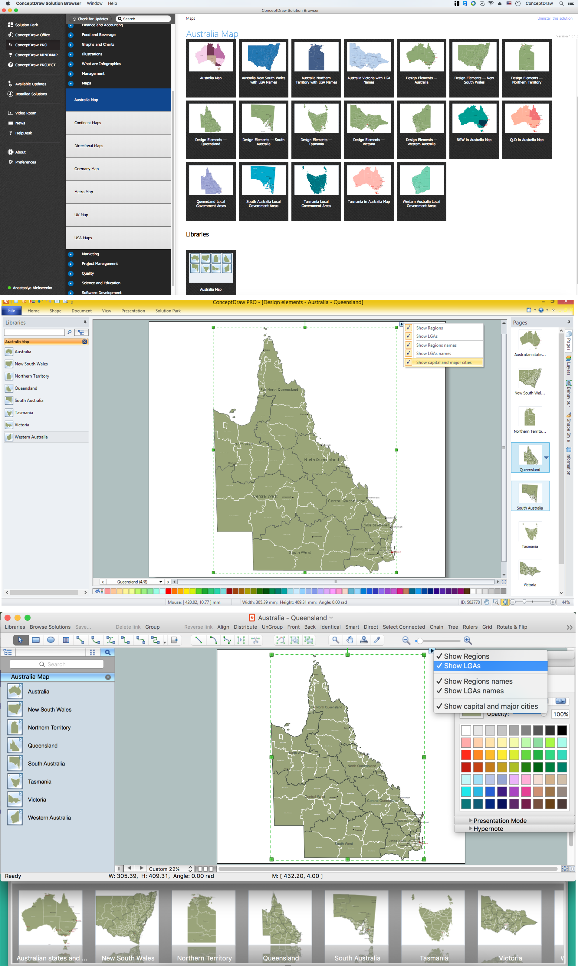
Australia Map — Queensland
- United Nation Logo And Its Member Countries
- Flags Of United Nation Pakistan United Kingdom Usa China France ...
- Map of USA with state names | Benefit Corporation legislation ...
- Andean states - Political map | South America regions - Political map ...
- Benefit Corporation legislation - Thematic map
- Map of USA | Geo Map - United States of America Map | Design ...
- North America Map With Nations And Capitals
- Cafeteria State Chart Diagram
- Benefit Corporation legislation - Thematic map | Continent Maps ...
- Southern Cone - Political map | South America regions - Political ...
- Geo Map - United States of America Map | Geo Map of Americas ...
- Design elements - Africa flags | Design elements - South America ...
- America Map With States
- South America regions - Political map | Canada regions - Political ...
- 2014 FIFA World Cup gualified teams
- How to Draw a Map of North America Using ConceptDraw PRO ...
- UML State Machine Diagram.Design Elements | UML Diagram ...
- South America regions - Political map | Southern Cone - Political ...
- Geo Map - Asia - Myanmar | Geo Map - South America Continent ...
- Georgia State Svg Image