Geo Map - South America - Mexico

The vector stencils library Mexico contains contours for ConceptDraw PRO diagramming and vector drawing software. This library is contained in the Continent Maps solution from Maps area of ConceptDraw Solution Park.
Geo Map - South America Continent

ConceptDraw PRO is idea to draw the geological maps of South America continent from the pre-designed vector geo map shapes.
Use Continent Maps solution from the Maps area of ConceptDraw Solution Park to draw thematic maps, geospatial infographics and vector illustrations for your business documents, presentations and websites.
Geo Map - South America - Bolivia

The vector stencils library Bolivia contains contours for ConceptDraw PRO diagramming and vector drawing software. This library is contained in the Continent Maps solution from Maps area of ConceptDraw Solution Park.
Geo Map - South America - Guyana

The vector stencils library Guyana contains contours for ConceptDraw PRO diagramming and vector drawing software. This library is contained in the Continent Maps solution from Maps area of ConceptDraw Solution Park.
Geo Map - South America - Puerto Rico

The vector stencils library Puerto Rico contains contours for ConceptDraw PRO diagramming and vector drawing software. This library is contained in the Continent Maps solution from Maps area of ConceptDraw Solution Park.
Geo Map - South America - Honduras

The vector stencils library Honduras contains contours for ConceptDraw PRO diagramming and vector drawing software. This library is contained in the Continent Maps solution from Maps area of ConceptDraw Solution Park.
Geo Map - South America - Peru

The history of Peru goes back to the distant past and its divided into several main stages. Geography of Peru is also diverse - there is a desert, as well as the ocean coast, and of course the mountain ranges.
The Continent Maps solution from Maps area of ConceptDraw Solution Park provides stencil library Peru, which is made up of well-designed vector shapes delivering easy experience in creating diagrams with ConceptDraw Pro software.
All ConceptDraw PRO documents are vector graphic files and are available for reviewing, modifying, and converting to a variety of formats: image, HTML, PDF file, MS PowerPoint Presentation, Adobe Flash, MS Visio (.VDX, .VSDX).
Geo Map - South America - Cuba

The vector stencils library Cuba contains contours for ConceptDraw PRO diagramming and vector drawing software. This library is contained in the Continent Maps solution from Maps area of ConceptDraw Solution Park.
Geo Map - South America - Paraguay

The vector stencils library Paraguay contains contours for ConceptDraw PRO diagramming and vector drawing software. This library is contained in the Continent Maps solution from Maps area of ConceptDraw Solution Park.
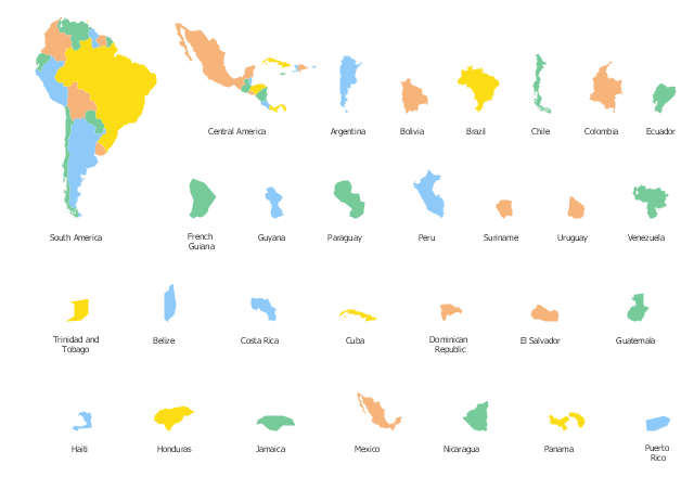
Use the map contours library "South America" to design thematic maps of South American countries using the ConceptDraw PRO diagramming and vector drawing software.
The vector stencils library "South America" contains 29 map contours: South America political map, Central America political map, state map contours of South American countries.
The map contours example "Design elements - South America" is included in the Continent Maps solution from the Maps area of ConceptDraw Solution Park.
South and Central America state map contours
Geo Map - South America - Jamaica

The vector stencils library Jamaica contains contours for ConceptDraw PRO diagramming and vector drawing software. This library is contained in the Continent Maps solution from Maps area of ConceptDraw Solution Park.
Geo Map - South America - Argentina

The vector stencils library Argentina contains contours for ConceptDraw PRO diagramming and vector drawing software. This library is contained in the Continent Maps solution from Maps area of ConceptDraw Solution Park.
Geo Map - South America - Venezuela

The vector stencils library Venezuela contains contours for ConceptDraw PRO diagramming and vector drawing software. This library is contained in the Continent Maps solution from Maps area of ConceptDraw Solution Park.
Geo Map - South America - Trinidad and Tobago

The vector stencils library Trinidad and Tobago contains contours for ConceptDraw PRO diagramming and vector drawing software. This library is contained in the Continent Maps solution from Maps area of ConceptDraw Solution Park.
Geo Map - South America - Ecuador

The vector stencils library Ecuador contains contours for ConceptDraw PRO diagramming and vector drawing software. This library is contained in the Continent Maps solution from Maps area of ConceptDraw Solution Park.
Geo Map - South America - Colombia

The vector stencils library Colombia contains contours for ConceptDraw PRO diagramming and vector drawing software. This library is contained in the Continent Maps solution from Maps area of ConceptDraw Solution Park.
Geo Map - South America - Panama

The vector stencils library Panama contains contours for ConceptDraw PRO diagramming and vector drawing software. This library is contained in the Continent Maps solution from Maps area of ConceptDraw Solution Park.
Geo Map - South America - Belize

The vector stencils library Belize contains contours for ConceptDraw PRO diagramming and vector drawing software. This library is contained in the Continent Maps solution from Maps area of ConceptDraw Solution Park.
Geo Map - South America - El Salvador

The vector stencils library El Salvador contains contours for ConceptDraw PRO diagramming and vector drawing software. This library is contained in the Continent Maps solution from Maps area of ConceptDraw Solution Park.
Geo Map - South America - Brazil

The vector stencils library Brazil contains contours for ConceptDraw PRO diagramming and vector drawing software. This library is contained in the Continent Maps solution from Maps area of ConceptDraw Solution Park.
- Geo Map - America | Geo Map - America - United States | Geo Map ...
- Design elements - South America | Map of USA with state names ...
- Geo Map - United States of America Map | Geo Map - South America ...
- Geo Map - South America Continent | Geo Map of America | Andean ...
- Geo Map of America | Geo Map - South America Continent | Geo ...
- North America map template | Design elements - South America ...
- Geo Map - America | Geo Map - America - United States | Geo Map ...
- Geo Map - America - United States | Geo Map - America | Geo Map ...
- South America flags - Stencils library | Geo Map - South America ...
- Languages of South America - Thematic map | Geo Map of America ...
- Argentina in South America - Political map | Geo Map - South ...
- Geo Map - America | Geo Map - South America | Geo Map - America ...
- Geo Map - America - United States | Design elements - USA | Geo ...
- Southern Cone - Political map | South America regions - Political ...
- Languages of South America map
- Languages of South America - Thematic map | Continent Maps ...
- Brazil in South America map | Geo Map - South America - Paraguay ...
- Geo Map - South America
- Map of USA with state names | Geo Map - South America - Haiti ...
- Languages of South America - Thematic map | Geo Map - South ...