HelpDesk
How to Draw Maps of Australia Using ConceptDraw PRO

Map of Australia

Geo Map - Australia - Victoria

 Australia Map
For graphic artists creating accurate maps of Australia. The Australia Map solution - allows designers to map Australia for their needs, offers a collection of scalable graphics representing the political geography of Australia, split into distinct state
 Education Package
Education Package is a comprehensive set of multifarious graphical solutions from ConceptDraw Solution Park, collected together in help to ConceptDraw PRO users working in a field of science, education and training, which is aimed at improving the quality of education and helping to design with ease variety of interesting and colorful educational materials, diagrams, charts and maps. Use it to present the information and knowledge in an interesting, clear, structured and simple form to achieve a success in education and pedagogy, to maintain the interest of students and pupils throughout the whole learning process, at the lectures, lessons and even during independent work with additional materials, to contribute to better perception of scientific information by listeners during the conferences and reports.
 Maps Area
Solutions from the Maps Area of ConceptDraw Solution Park collect templates, samples and libraries of vector stencils for drawing geographical, directional and transport maps.
Geo Map - South America Continent

Australia Map — Queensland

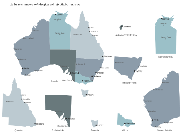
This sample displays map contours with capitals and main cities of Australia . Use it design your management infographics.
"The states and mainland territories of the Commonwealth of Australia combine to make up the world's sixth-largest country by total area. Australia comprises six states and various territories; the Australian mainland is made up of five states and three territories (including small, somewhat anomalous Jervis Bay Territory), with the sixth state being located on the island of Tasmania to the south of the mainland. In addition, there are six island territories, known as external territories. Australia also claims part of Antarctica as the Australian Antarctic Territory." [States and territories of Australia. Wikipedia]
The infogram shapes example "Design elements - Management map Australia" was created using the ConceptDraw PRO diagramming and vector drawing software extended with the Management Infographics solition from the area "Business Infographics" in ConceptDraw Solution Park.
Australia state map contours
Business Package for Management
Package intended for professional who designing and documenting business processes, preparing business reports, plan projects and manage projects, manage organizational changes, prepare operational instructions, supervising specific department of an organization, workout customer service processes and prepare trainings for customer service personal, carry out a variety of duties to organize business workflow.
Geo Map - Australia - New Zealand

Geo Map - USA - Oklahoma

Geo Map - USA - Louisiana

Geo Map - USA - Washington

Map Australia

- Australia map with cities - Template | Australia map - Template ...
- Australia states time zones - Thematic map | Design elements ...
- Australian State Capitals Map
- Canada Map With States And Cities
- Canadian States And Capitals
- Geo Map - Asia - Syria | Geo Map - Asia | Geo Map - United States of ...
- United States Of Australia Map
- Design elements - Management map Australia
- Geo Map - Canada - Northwest Territories
- Geo Map - Europe | Design elements - Asia | Design elements ...
- Major Cities In Germany Map
- Geo Map - Australia
- How to Draw Maps of Australia Using ConceptDraw PRO | Geo Map ...
- Germany Map With Major Cities
- Australia Map Big Cities
- Geo Map - Asia - Papua New Guinea | Geo Map - Australia | Design ...
- How To Draw Outline Of States In Map
- Fundamental Tool in Quality Management | Mind Mapping in the ...
- The Map Of States
- Sales Plan | Sales Dashboard | Australia Map | Sales Territory ...