Geo Map - Asia - Syria

Geo Map — Asia

Geo Map — United States of America Map

Geo Map - Canada

Geo Map - Africa

Geo Map — Europe — France

Geo Map — Australia — New Zealand

Geo Map of Americas

World Continents Map

Geo Map - South America - Guatemala

 Concept Maps
The technique of concept mapping was developed as a constructive way of representing knowledge in science and increasing the meaningfulness of learning. Now, the creation of a concept map is extremely helpful when used in education as learning and teaching techniques that assist memorization. Concept maps are also used for idea generation in brainstorming sessions, and for detailing the structure of complex ideas.
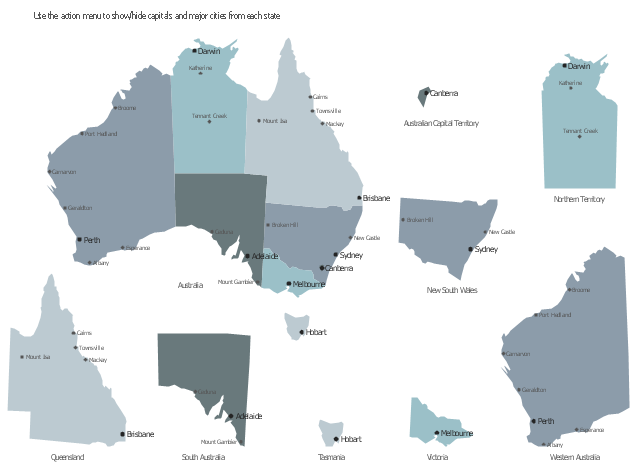
This sample displays map contours with capitals and main cities of Australia . Use it design your management infographics.
"The states and mainland territories of the Commonwealth of Australia combine to make up the world's sixth-largest country by total area. Australia comprises six states and various territories; the Australian mainland is made up of five states and three territories (including small, somewhat anomalous Jervis Bay Territory), with the sixth state being located on the island of Tasmania to the south of the mainland. In addition, there are six island territories, known as external territories. Australia also claims part of Antarctica as the Australian Antarctic Territory." [States and territories of Australia. Wikipedia]
The infogram shapes example "Design elements - Management map Australia" was created using the ConceptDraw PRO diagramming and vector drawing software extended with the Management Infographics solition from the area "Business Infographics" in ConceptDraw Solution Park.
Australia state map contours
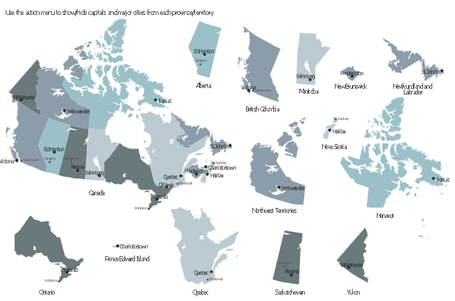
This sample displays state map contours with capitals and major cities of Canada provinces and territories. Use it to design your management infographics.
"The provinces and territories of Canada combine to make up the world's second-largest country by area. ... The ten provinces are Alberta, British Columbia, Manitoba, New Brunswick, Newfoundland and Labrador, Nova Scotia, Ontario, Prince Edward Island, Quebec, and Saskatchewan. The three territories are Northwest Territories, Nunavut, and Yukon." [Canada. Wikipedia]
The infogram shapes example "Design elements - Management map Canada" was created using the ConceptDraw PRO diagramming and vector drawing software extended with the Management Infographics solition from the area "Business Infographics" in ConceptDraw Solution Park.
Canada state map contours
How To Create Restaurant Floor Plan in Minutes

 Landscape & Garden
The Landscape and Gardens solution for ConceptDraw PRO v10 is the ideal drawing tool when creating landscape plans. Any gardener wondering how to design a garden can find the most effective way with Landscape and Gardens solution.
- Geo Map - Europe | EU 28: Candidate countries map | Geo Map ...
- West Africa countries | Geo Map - Africa | Geo Map - Africa - Guinea ...
- Continent Maps | Geo Map Software | Design elements - South ...
- Geo Map Software | East Africa countries map | West Africa countries ...
- Geo Map - Europe | Asia - Vector stencils library | Europe - Vector ...
- Geo Map - Europe | Maghreb countries - Political map | EU 28 ...
- Africa | Maps
- Geo Map - America
- Geo Map of America
- Geo Map - South America - Paraguay | Geo Map - South America ...
- Geo Map - America - United States
- Geo Map - Asia
- Geo Map - America
- Design elements - Asia | Geo Map - Asia | Continent Maps | Asian ...
- Brazil in South America map | Geo Map - South America - Paraguay ...
- Geo Map - Africa
- Geo Map - America
- Continent Maps | Design elements - Continental map | How to Draw ...
- Geo Map - Africa