Geo Map - Asia - Japan

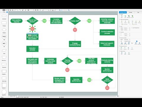
Types of Flowchart - Overview

Landscape Plan

 USA Maps
Use the USA Maps solution to create a map of USA, a US interstate map, printable US maps, US maps with cities and US maps with capitals. Create a complete USA states map.
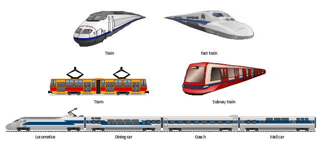
The vector clipart library Rail transport contains 8 images: railway train, fast train, subway train, tram, locomotive, dining car, coach, mail car.
Use the vector stencils library Rail transport to draw train illustrations, presentation slides, infographics and diagrams using the ConceptDraw PRO diagramming and vector drawing software.
"Rail transport is a means of conveyance of passengers and goods, by way of wheeled vehicles running on rails. It is also commonly referred to as train transport. In contrast to road transport, where vehicles merely run on a prepared surface, rail vehicles are also directionally guided by the tracks on which they run. Track usually consists of steel rails installed on sleepers/ ties and ballast, on which the rolling stock, usually fitted with metal wheels, moves. However, other iations are also possible, such as slab track where the rails are fastened to a concrete foundation resting on a prepared subsurface. Rolling stock in railway transport systems generally has lower frictional resistance when compared with highway vehicles and the passenger and freight cars (carriages and wagons) can be coupled into longer trains. The operation is carried out by a railway company, providing transport between train stations or freight customer facilities. Power is provided by locomotives which either draw electrical power from a railway electrification system or produce their own power, usually by diesel engines. Most tracks are accompanied by a signalling system. Railways are a safe land transport system when compared to other forms of transport." [Rail transport. Wikipedia]
The design elements library Rail transport is included in the Aerospace and Transport solution from the Illustration area of ConceptDraw Solution Park.
Vector clip art
 Pie Charts
Pie Charts are extensively used in statistics and business for explaining data and work results, in mass media for comparison (i.e. to visualize the percentage for the parts of one total), and in many other fields. The Pie Charts solution for ConceptDraw PRO v10 offers powerful drawing tools, varied templates, samples, and a library of vector stencils for simple construction and design of Pie Charts, Donut Chart, and Pie Graph Worksheets.
Geo Map — Europe

Geo Map — Asia — Indonesia

Geo Map - South America - Jamaica

Geo Map - Africa - Niger

Geo Map - Canada

7 Continents Map

 Sales Flowcharts
The Sales Flowcharts solution lets you create and display sales process maps, sales process workflows, sales steps, the sales process, and anything else involving sales process management.
Building Drawing Design Element: Piping Plan


Bubble diagrams in Landscape Design with ConceptDraw PRO

- Professions - Vector stencils library | Land sales process flowchart ...
- Map Elements Land Clipart Png
- Geo Map - Asia - Saudi Arabia | Walking Woman Clipart Png
- Png Vector Clipart Wood Biomass Wind Turbine Wind Turbine Solar
- Construction Vehicles Png
- Women Walking Vector Png
- Consultant Png
- Mountains Clipart Png
- Blue Hills Clipart Png
- River Clip Art Png
- Railway Clipart Png
- Walk Clipart Png
- Hill Clipart Png
- Mountain Hill Clipart Png
- Waterfall Png
- Wind Turbine Clipart Free Png
- Png Images Of Mountains Vector
- Png Hills
- Vehicles Clipart Png
- Railway Track Logo Png