Geo Map - Asia

Use Geo Map Asia to draw thematic maps, geospatial infographics and vector illustrations for your business documents, presentations and websites.
Geo Map - Asia - Japan

The vector stencils library Japan contains contours for ConceptDraw PRO diagramming and vector drawing software. This library is contained in the Continent Maps solution from Maps area of ConceptDraw Solution Park.
Geo Map - Asia - Indonesia

The vector stencils library Indonesia contains contours for ConceptDraw PRO diagramming and vector drawing software. This library is contained in the Continent Maps solution from Maps area of ConceptDraw Solution Park.
Geo Map - Asia - Thailand

The vector stencils library Thailand contains contours for ConceptDraw PRO diagramming and vector drawing software. This library is contained in the Continent Maps solution from Maps area of ConceptDraw Solution Park.
Geo Map - Asia - Yemen

The vector stencils library Yemen contains contours for ConceptDraw PRO diagramming and vector drawing software. This library is contained in the Continent Maps solution from Maps area of ConceptDraw Solution Park.
Geo Map - Asia - Kazakhstan

The vector stencils library Kazakhstan contains contours for ConceptDraw PRO diagramming and vector drawing software. This library is contained in the Continent Maps solution from Maps area of ConceptDraw Solution Park.
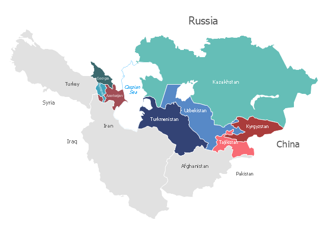
"Central Asia is the core region of the Asian continent and stretches from the Caspian Sea in the west to China in the east and from Afghanistan in the south to Russia in the north. It is also sometimes referred to as Middle Asia, and, colloquially, "the 'stans" (as the six countries generally considered to be within the region all have names ending with the Persian suffix "-stan", meaning "land of") and is within the scope of the wider Eurasian continent.
In modern contexts, all definitions of Central Asia include these five republics of the former Soviet Union: Kazakhstan (pop. 17.9 million), Kyrgyzstan (5.8 million), Tajikistan (8.0 million), Turkmenistan (5.2 million), and Uzbekistan (30.2 million), for a total population of 67.1 million as of 2013-2014. Afghanistan (pop. 31.1 million) is also sometimes included." [Central Asia. Wikipedia]
"The Caucasus / ˈkɔːkəsəs/ or Caucasia / kɔːˈkeɪʒə/ (for endonyms, see below), is a region at the border of Europe and Asia, situated between the Black and the Caspian seas. It is home to the Caucasus Mountains, which contain Europe's highest mountain, Mount Elbrus. Politically, the Caucasus region is separated between northern and southern parts. The southern parts consist of independent sovereign states: Abkhazia, Armenia, Azerbaijan, Georgia, Nagorno-Karabakh, South Ossetia, Turkey (part), Iran (part). The northern parts are under the jurisdiction of the Russian Federation." [Caucasus. Wikipedia]
This political map sample was redesigned from the Wikimedia Commons file: Caucasus central asia political map 2000.jpg. [commons.wikimedia.org/ wiki/ File:Caucasus_ central_ asia_ political_ map_ 2000.jpg]
The example "Caucasus and Central Asia 2000 - Political map" was created using the ConceptDraw PRO diagramming and vector drawing software extended with the Continent Maps solution from the Maps area of ConceptDraw Solution Park.
Political map - Caucasus and Central Asia 2000
Geo Map - South America - Peru

The history of Peru goes back to the distant past and its divided into several main stages. Geography of Peru is also diverse - there is a desert, as well as the ocean coast, and of course the mountain ranges.
The Continent Maps solution from Maps area of ConceptDraw Solution Park provides stencil library Peru, which is made up of well-designed vector shapes delivering easy experience in creating diagrams with ConceptDraw Pro software.
All ConceptDraw PRO documents are vector graphic files and are available for reviewing, modifying, and converting to a variety of formats: image, HTML, PDF file, MS PowerPoint Presentation, Adobe Flash, MS Visio (.VDX, .VSDX).
Continents Map

Geo Map of Americas

ConceptDraw is idea to draw the geological maps of America from the pre-designed vector geo map shapes and vector images map of america.
Use Continent Maps solution from the Maps area of ConceptDraw Solution Park to draw thematic maps, geospatial infographics and vector illustrations for your business documents, presentations and websites.
Geo Map - Europe

ConceptDraw PRO is idea to draw the geological maps of Europe from the pre-designed vector geo map shapes.
Use it to draw thematic maps, geospatial infographics and vector illustrations for your business documents, presentations and websites.
Geo Map - USA - Alaska

The vector stencils library Alaska contains contours for ConceptDraw PRO diagramming and vector drawing software. This library is contained in the Continent Maps solution from Maps area of ConceptDraw Solution Park.
Continents Map
Geo Map - South America Continent

ConceptDraw PRO is idea to draw the geological maps of South America continent from the pre-designed vector geo map shapes.
Use Continent Maps solution from the Maps area of ConceptDraw Solution Park to draw thematic maps, geospatial infographics and vector illustrations for your business documents, presentations and websites.
Geo Map - Africa - Uganda

The vector stencils library Uganda contains contours for ConceptDraw PRO diagramming and vector drawing software. This library is contained in the Continent Maps solution from Maps area of ConceptDraw Solution Park.
- South America regions - Political map | South Asia - Political map ...
- Design elements - Asia | Geo Map - Asia | Continent Maps | Asian ...
- Continent Maps | Central Asia - Political map | Political map of Asia ...
- A Sovereign Country In South Asia
- How To Draw Map Of South Asia
- South Asia Map Example
- Geo Map - Asia - Vietnam | Continent Maps | Central Asia - Political ...
- Asia Continent Map
- Continent Maps | Design elements - Continental map | How to Draw ...
- Geo Map - Asia - Pakistan | Central Asia - Political map | Geo Map ...
- Names Of Countries In Asia
- Geo Map - Asia - India
- Asia Continents
- Political map of Central America | South Asia - Political map ...
- Map Of Asia With Country Names
- Middle East - Political map | Geo Map - Asia | Continent Maps | Map ...
- Political map of Asia
- Geo Map - Asia - Pakistan | Asia flags - Stencils library | Asia flags ...
- Geo Map - Asia - Japan | Asia - Vector stencils library | Asia - Vector ...
- Geo Map - Asia - Turkey | Asia - Vector stencils library | European ...