Infographic design elements, software tools Subway and Metro style

The vector stencils library "Transport maps" contains 34 shapes for designing the transportation maps, metro maps, subway maps, underground maps, tube maps using the ConceptDraw PRO diagramming and vector drawing software extended with the Metro Map solution from the Maps area of ConceptDraw Solution Park.
Metro map shapes
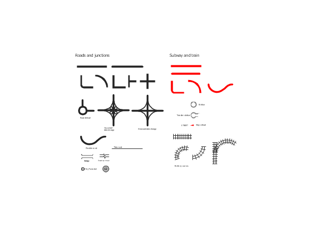
The vector stencils library "Roads and junctions" contains 38 symbols for creating the road and route maps, transit and directional maps, street and locator maps using the ConceptDraw PRO diagramming and vector drawing software.
The vector stencils library "Subway and train" contains 22 shapes for creating the transit maps of tube (metro) and railway.
"Road maps are perhaps the most widely used maps today, and form a subset of navigational maps, which also include aeronautical and nautical charts, railroad network maps, and hiking and bicycling maps." [Map. Wikipedia]
The example "Design elements - Roads and junctions, subway and train" is included in the Directional Maps solution from the Maps area of ConceptDraw Solution Park.
Road map stencils
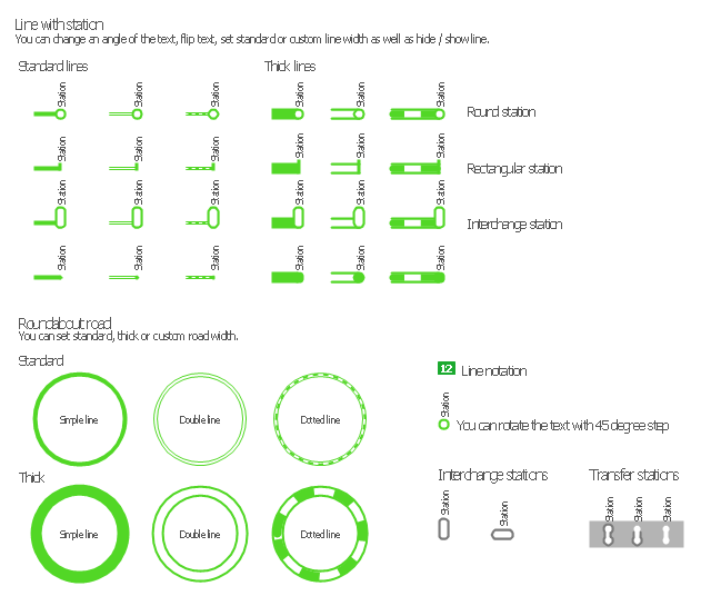
 Metro Map
Metro Map solution extends ConceptDraw PRO software with templates, samples and library of vector stencils for drawing the metro maps, route maps, bus and other transport schemes, or design tube-style infographics.
Metro Map

The Metro Map Solution from the Maps Area uses two ConceptDraw techniques: Replicating Objects and Switching Objects. And the result is a vector graphic document.
"A landmark is a recognizable natural or man-made feature used for navigation. ...
In urban studies as well as in geography, a landmark is furthermore defined as an external point of reference that helps orienting in a familiar or unfamiliar environment. ...
Landmarks are usually classified under natural landmarks or man-made landmarks, both are originally used to help navigation on finding direction. A variant is a seamark or daymark, a structure usually built intentionally to aid sailors navigating featureless coasts." [Landmark. Wikipedia]
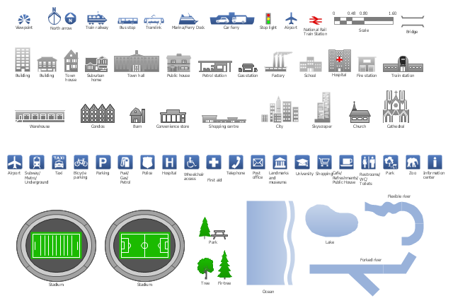
The vector stencils library Landmarks contains symbols for drawing directional maps, street maps, road maps, route maps, locator maps, transit maps, tourist maps using the ConceptDraw PRO diagramming and vector drawing software.
The example "Design elements - Landmarks" is included in the Directional Maps solution from the Maps area of ConceptDraw Solution Park.
In urban studies as well as in geography, a landmark is furthermore defined as an external point of reference that helps orienting in a familiar or unfamiliar environment. ...
Landmarks are usually classified under natural landmarks or man-made landmarks, both are originally used to help navigation on finding direction. A variant is a seamark or daymark, a structure usually built intentionally to aid sailors navigating featureless coasts." [Landmark. Wikipedia]
The vector stencils library Landmarks contains symbols for drawing directional maps, street maps, road maps, route maps, locator maps, transit maps, tourist maps using the ConceptDraw PRO diagramming and vector drawing software.
The example "Design elements - Landmarks" is included in the Directional Maps solution from the Maps area of ConceptDraw Solution Park.
Landmarks
Rail transport - Design elements

Use it to draw illustrations of trains and transportation of passengers and goods by railroads.
 Aerospace and Transport
This solution extends ConceptDraw PRO software with templates, samples and library of vector clipart for drawing the Aerospace and Transport Illustrations. It contains clipart of aerospace objects and transportation vehicles, office buildings and anci
- How to draw Metro Map style infographics? (London) | Infographic ...
- Design elements - 3D directional maps | Design elements - Subway ...
- Metro Map | Best Value Stream Mapping mac Software | Subway ...
- Value Stream Mapping - Design Elements | Subway infographic ...
- Infographic design elements , software tools Subway and Metro style ...
- Infographic design elements , software tools Subway and Metro style ...
- Design elements - Subway map , Map symbols | How to draw Metro ...
- How to draw Metro Map style infographics? (New York) | Infographic ...
- Spatial infographics Design Elements : Transport Map | Maps | Metro ...
- Infographic design elements , software tools Subway and Metro style ...
- Subway infographic design elements - software tools | Map ...
- Maps | Spatial infographics Design Elements : Transport Map | Metro ...
- Infographic design elements , software tools Subway and Metro style ...
- Metro Map | Design elements - Metro maps | How to draw Metro Map ...
- Subway infographic design elements - software tools | Infographic ...
- How to draw Metro Map style infographics? (New York)
- Map Infographic Design | Spatial infographics Design Elements ...
- Subway infographic design elements - software tools ...
- Rail transport - Design elements | Los Angeles county Metro Rail ...
- Spatial infographics Design Elements : Transport Map