Interior Design. Office Layout Plan Design Element


The vector stencils library Map symbols contains 19 icons for labeling the maps using the ConceptDraw PRO diagramming and vector drawing software.
The vector stencils library Subway map contains 41 shapes for creating the subway (tube, metro) maps using the ConceptDraw PRO.
"The various features shown on a map are represented by conventional signs or symbols. For example, colors can be used to indicate a classification of roads. Those signs are usually explained in the margin of the map, or on a separately published characteristic sheet.
Some cartographers prefer to make the map cover practically the entire screen or sheet of paper, leaving no room "outside" the map for information about the map as a whole. These cartographers typically place such information in an otherwise "blank" region "inside" the map -- cartouche, map legend, title, compass rose, bar scale, etc. In particular, some maps contain smaller "sub-maps" in otherwise blank regions—often one at a much smaller scale showing the whole globe and where the whole map fits on that globe, and a few showing "regions of interest" at a larger scale in order to show details that wouldn't otherwise fit." [Map. Wikipedia]
The example "Design elements - Subway map, Map symbols" is included in the Directional Maps solution from the Maps area of ConceptDraw Solution Park.
Map symbols

Geo Map - Africa

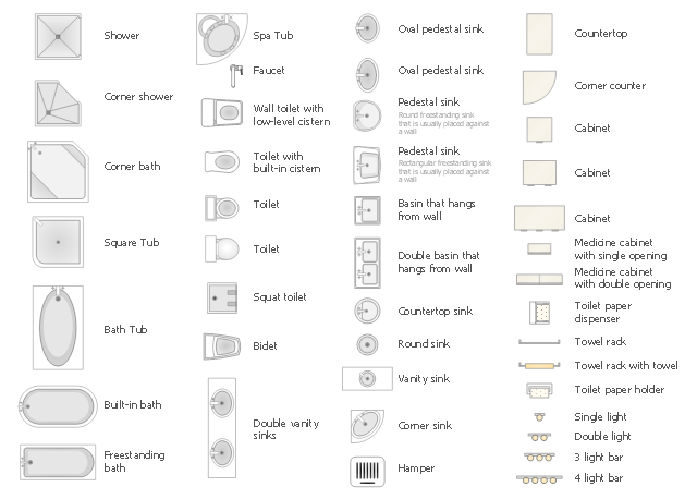
The vector stencils library Bathroom contains 41 symbols of bathtubs, toilets, faucets, sinks, showers, bathroom furniture.
Use the shapes library Bathroom to draw the bathroom furniture and equipment layouts and bathroom interioir plans using the ConceptDraw PRO diagramming and vector drawing software.
"A bathroom is a room for personal hygiene, generally containing a bathtub or a shower, and possibly also a bidet. In North America and some other regions, it characteristically contains a toilet and a sink...
Variations: Powder room, Shower room, Ensuite, Family bathroom, Jack and Jill bathroom, Wetroom." [Bathroom. Wikipedia]
The design elements library Bathroom is provided by the Floor Plans solution from Building Plans area of ConceptDraw Solution Park.
Geo Map - Europe - Norway

The vector stencils library "Landmarks" contains 34 signs and pictograms for drawing road and transit maps.
The vector stencils library "Map symbols" contains 10 signs and pictograms for drawing road and transit maps.
"A landmark is a recognizable natural or man-made feature used for navigation, a feature that stands out from its near environment and is often visible from long distances.
In modern use, the term can also be applied to smaller structures or features, that have become local or national symbols." [Landmark. Wikipedia]
The pictograms example "Design elements - Location map" was created using the ConceptDraw PRO diagramming and vector drawing software extended with the Spatial Infographics solution from the Maps area of ConceptDraw Solution Park.
Landmarks and Map symbols

Geo Map — United States of America Map

 USA Maps
Use the USA Maps solution to create a map of USA, a US interstate map, printable US maps, US maps with cities and US maps with capitals. Create a complete USA states map.
Geo Map - Asia - North Korea

Spatial infographics Design Elements: Location Map

 Business Package for Management
Package intended for professional who designing and documenting business processes, preparing business reports, plan projects and manage projects, manage organizational changes, prepare operational instructions, supervising specific department of an organization, workout customer service processes and prepare trainings for customer service personal, carry out a variety of duties to organize business workflow.
HelpDesk
How to Draw a Map of North America

Geo Map — Asia

Geo Map - Europe - United Kingdom

Directions Maps

- Map symbols - Vector stencils library | Interior Design Office Layout ...
- Floor Plan North Symbol
- UK Map | Architecture Visualization North Symbol Png
- Architectural North Arrows
- Map symbols - Vector stencils library | Design elements - Subway ...
- Map symbols - Vector stencils library
- North Arrow Architecture Symbol
- North Symbol Floor Plan
- Minimalist North Symbol
- Symbol Of Ruins In A Map
- North Symbol Architecture
- North Arrow Architecture
- Map symbols - Vector stencils library | USA Maps | Germany Map ...
- North Symbol Architecture Png
- Symbol Of Curiosity
- North Architectural Symbol
- Different Symbol Of North Direction
- Directions Maps | UK Map | Map of USA | North Direction Symbol Visio
- Design elements - Subway map, Map symbols | Map symbols ...
- Map symbols - Vector stencils library | Design elements - Location ...