Geo Map - Asia - Japan

Geo Map - Asia - Vietnam

Geo Map - Asia - Thailand

Geo Map - Asia - Malaysia

Geo Map - Asia - Nepal

Geo Map - Asia - Kuwait

Geo Map - Asia - Kazakhstan

Geo Map - Asia - Myanmar

Geo Map - Asia - Mongolia

Geo Map - Asia - Saudi Arabia

Geo Map - Asia - Indonesia

Use the map contours library "Asia" to design thematic maps of Asian countries using the ConceptDraw PRO diagramming and vector drawing software.
"Asia ... is the world's largest and most populous continent, located primarily in the eastern and northern hemispheres. ...
The boundaries of Asia are culturally determined, as there is no clear geographical separation between it and Europe, which together form one continuous landmass called Eurasia. The most commonly accepted boundaries place Asia to the east of the Suez Canal, the Ural River, and the Ural Mountains, and south of the Caucasus Mountains (or the Kuma–Manych Depression) and the Caspian and Black Seas. It is bounded on the east by the Pacific Ocean, on the south by the Indian Ocean and on the north by the Arctic Ocean." [Asia. Wikipedia]
The vector stencils library "Asia" contains 57 map contours: Asia state map contours, Asia political map, sea contours, lake contours.
The map contours example "Design elements - Asia" is included in the Continent Maps solution from the Maps area of ConceptDraw Solution Park.
Asia map contours

Geo Map - Asia - Papua New Guinea

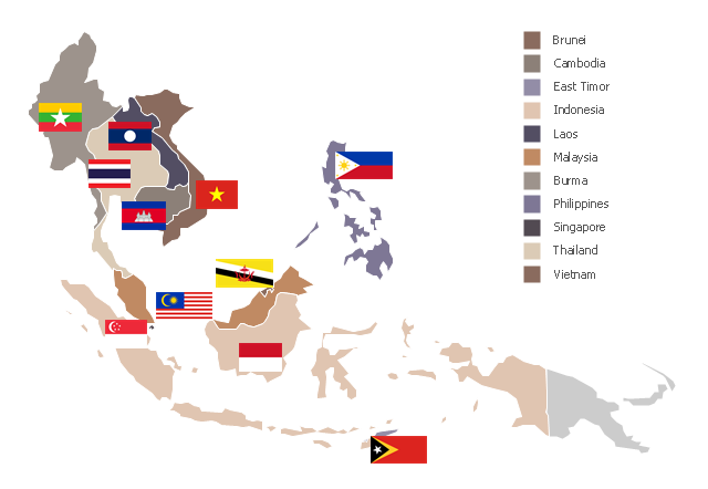
"Southeast Asia or Southeastern Asia is a subregion of Asia, consisting of the countries that are geographically south of China, east of India, west of New Guinea and north of Australia. The region lies near the intersection of geological plates, with heavy seismic and volcanic activity. Southeast Asia consists of two geographic regions:
(1) Maritime Southeast Asia, comprising Philippines, East Malaysia, East Timor, Indonesia, Brunei, and Singapore.
(2) Mainland Southeast Asia, also known as Indochina, comprising Cambodia, Laos, Myanmar (Burma), Thailand, West Malaysia and Vietnam." [Southeast Asia. Wikipedia]
This political map sample was redesigned from the Wikimedia Commons file: Suresteasia324.jpg. [commons.wikimedia.org/ wiki/ File:Suresteasia324.jpg]
This file is licensed under the Creative Commons Attribution-Share Alike 3.0 Unported license. [creativecommons.org/ licenses/ by-sa/ 3.0/ deed.en]
The example "Southeast Asia - Political map" was created using the ConceptDraw PRO diagramming and vector drawing software extended with the Continent Maps solution from the Maps area of ConceptDraw Solution Park.
Political map - Southeast Asia
- Map Of Vietnam Png
- Map Korea Png
- India Old Map With States Vector Png
- Uae Map Outline Png
- Japan Map Png Image
- China Map Png Image
- Asean Countries Map Png
- China Map Geo Png
- Kuwait Map Outline Png
- India Outline Map Png
- Singapore Map Outline Design Png
- Saudi Arabia Outline Map Png
- Bahrain Map Outline Color Png
- Greater China Map Png
- Thailand Map Outline Png
- Asia Outline Png
- Indian Map Vector Png
- Saudi Arabia Map Outline Png
- Geo Map - Asia - Japan
- Malaysia Map Transparent Png