HelpDesk
How to Support Your Mind Map with Visual Elements


Subway infographic design elements - software tools

Spatial infographics Design Elements: Continental Map

Spatial infographics Design Elements: Location Map

"A thematic map is a type of map or chart especially designed to show a particular theme connected with a specific geographic area. ...
A thematic map is a map that focuses on a specific theme or subject area, whereas in a general map the variety of phenomena - geological, geographical, political - regularly appear together. ...
Thematic maps emphasize spatial variation of one or a small number of geographic distributions. These distributions may be physical phenomena such as climate or human characteristics such as population density and health issues. ...
Thematic map are sometimes referred to as graphic essays that portray spatial variations and interrelationships of geographical distributions. Location, of course, is important to provide a reference base of where selected phenomena are occurring. ...
Thematic maps serve three primary purposes.
First, they provide specific information about particular locations.
Second, they provide general information about spatial patterns.
Third, they can be used to compare patterns on two or more maps." [Thematic map. Wikipedia]
The vector stencils library "Thematic maps" contains 7 continent map contours for creating the thematic maps of geographic regions displaying the metric values by countries, states and territories marked by different colors.
Use the design elements library "Thematic maps" to create spatial dashboards using the ConceptDraw PRO diagramming and vector drawing software for your Spatial Intelligence and Location Intelligence business practice.
The example "Design elements - Thematic maps" is included in the Spatial Dashboard solution from the area "What is a Dashboard" of ConceptDraw Solution Park.
Thematic map templates

Spatial infographics Design Elements: Transport Map

Geo Map - Asia

Use Geo Map Asia to draw thematic maps, geospatial infographics and vector illustrations for your business documents, presentations and websites.
The vector stencils library "3D directional maps" contains 40 symbols for creating pictorial maps, street maps, locator maps, transit maps, tourist maps with points of interest (POI), road maps and route maps using the ConceptDraw PRO diagramming and vector drawing software.
"Pictorial maps are a category of maps that are also loosely called illustrated maps, panoramic maps, perspective maps, bird’s-eye view maps and Geopictorial maps amongst others. In contrast to the regular road map, Atlas or topographic cartography, pictorial maps depict a given territory with a more artistic rather than technical style. The cartography can be a sophisticated 3-D perspective landscape or a simple map graphic enlivened with illustrations of buildings, people and animals. They can feature all sorts of varied topics like historical events, legendary figures or local agricultural products and cover anything from an entire continent to a college campus. ...
Pictorial maps usually show an area as if viewed from above at an oblique angle. They are not generally drawn to scale in order to show street patterns, individual buildings, and major landscape features in perspective. While regular maps focus on the accurate rendition of distances, pictorial maps enhance landmarks and often incorporate a complex interplay of different scales into one image in order to give the viewer a more familiar sense of recognition." [Pictorial maps. Wikipedia]
The design elements library "3D directional maps" is included in the Directional Maps solution from the Maps area of ConceptDraw Solution Park.
3D pictorial map symbols

Infographic design elements, software tools Subway and Metro style

Geo Map - Africa

Vector design elements library Africa contains country map contours, geographical maps, cartograms and thematic maps for ConceptDraw PRO diagramming and vector drawing software. To help visualize the business and thematic information connected with geographic areas, locations or customs.
All ConceptDraw PRO documents are vector graphic files and are available for reviewing, modifying, and converting to a variety of formats: image, HTML, PDF file, MS PowerPoint Presentation, Adobe Flash, MS Visio (.VDX, .VSDX).
The vector stencils library "Education maps" contains 44 map contours: the Group of Twenty (G20) state maps, EU state maps and world map.
Use it to visualize geospatial information on thematic maps in your education infograms.
"A world map is a map of most or all of the surface of the Earth. ...
A thematic map shows geographic information about one or a few focused subjects." [World map. Wikipedia]
The political World map example "Design elements - Education maps (World map)" was created using the ConceptDraw PRO diagramming and vector drawing software extended with the Education Infographics solition from the area "Business Infographics" in ConceptDraw Solution Park.
World map
.png--diagram-flowchart-example.png)
The vector stencils library "Transport map" contains 96 signs and pictograms for drawing road and transit maps.
"A transit map is a topological map in the form of a schematic diagram used to illustrate the routes and stations within a public transport system - whether this be bus lines, tramways, rapid transit, commuter rail or ferry routes. The main components are color coded lines to indicate each line or service, with named icons to indicate stations or stops.
Transit maps can be found in the transit vehicles, at the platforms or in printed timetables. Their primary function is to help users to efficiently use the public transport system, including which stations function as interchange between lines. Unlike conventional maps, transit maps are usually not geographically accurate - instead they use straight lines and fixed angles, and often illustrate a fixed distance between stations, compressing those in the outer area of the system and expanding those close to the center." [Transit map. Wikipedia]
The pictograms example "Design elements - Transport map" was created using the ConceptDraw PRO diagramming and vector drawing software extended with the Spatial Infographics solution from the Maps area of ConceptDraw Solution Park.
Transport map pictograms

The vector stencils library "Landmarks" contains 34 signs and pictograms for drawing road and transit maps.
The vector stencils library "Map symbols" contains 10 signs and pictograms for drawing road and transit maps.
"A landmark is a recognizable natural or man-made feature used for navigation, a feature that stands out from its near environment and is often visible from long distances.
In modern use, the term can also be applied to smaller structures or features, that have become local or national symbols." [Landmark. Wikipedia]
The pictograms example "Design elements - Location map" was created using the ConceptDraw PRO diagramming and vector drawing software extended with the Spatial Infographics solution from the Maps area of ConceptDraw Solution Park.
Landmarks and Map symbols

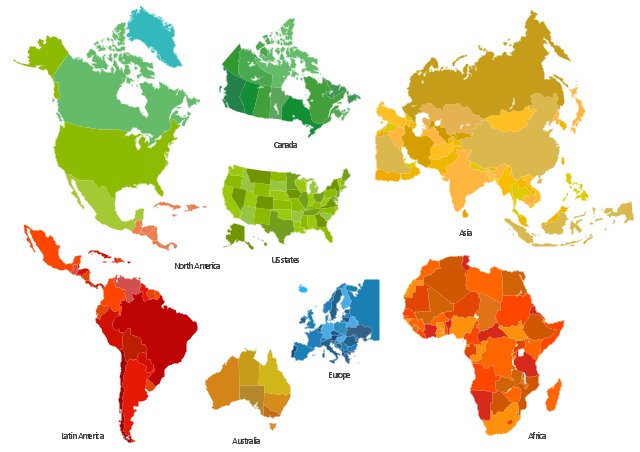
The vector stencils library "Africa" contains 51 African countries contour maps.
The vector stencils library "Asia" contains 47 Asian countries contour maps.
The vector stencils library "Australia and New Zealand" contains 10 contour maps.
The vector stencils library "Europe" contains 39 European countries contour maps.
The vector stencils library "Latin America" contains 30 Latin American countries contour maps.
The vector stencils library "North America" contains 70 North American countries contour maps.
"A continent is one of several very large landmasses on Earth. They are generally identified by convention rather than any strict criteria, with up to seven regions commonly regarded as continents. These are from largest in size to smallest: Asia, Africa, North America, South America, Antarctica, Europe, and Australia." [Continent. Wikipedia]
The contour maps example "Design elements - Continental map" was created using the ConceptDraw PRO diagramming and vector drawing software extended with the Spatial Infographics solution from the Maps area of ConceptDraw Solution Park.
Continental contour maps
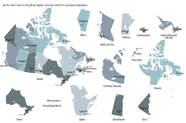
This sample displays state map contours with capitals and major cities of Canada provinces and territories. Use it to design your management infographics.
"The provinces and territories of Canada combine to make up the world's second-largest country by area. ... The ten provinces are Alberta, British Columbia, Manitoba, New Brunswick, Newfoundland and Labrador, Nova Scotia, Ontario, Prince Edward Island, Quebec, and Saskatchewan. The three territories are Northwest Territories, Nunavut, and Yukon." [Canada. Wikipedia]
The infogram shapes example "Design elements - Management map Canada" was created using the ConceptDraw PRO diagramming and vector drawing software extended with the Management Infographics solition from the area "Business Infographics" in ConceptDraw Solution Park.
Canada state map contours
- Design elements - 3D directional maps | Directional Maps | Maps ...
- Design elements - Transport map | Subway Map | Subway Train ...
- Spatial infographics Design Elements : Continental Map | Spatial ...
- Value Stream Mapping | Value Stream Mapping - Design Elements ...
- Spatial infographics Design Elements : Location Map | Design ...
- Hotel locator map | Maps | Design elements - 3D directional maps ...
- Design elements - Subway map , Map symbols | How to draw Metro ...
- Spatial infographics Design Elements : Continental Map | Subway ...
- Geo Map - Europe | Spatial infographics Design Elements ...
- Spatial infographics Design Elements : Continental Map | Design ...
- Spatial infographics Design Elements : Location Map | Directional ...
- Subway infographic design elements - software tools | Spatial ...
- Marketing | Internet marketing - Concept map | Design elements ...
- How to Support Your Mind Map with Visual Elements | How to ...
- 3D pictorial street map | Design elements - 3D directional maps ...
- Spatial infographics Design Elements : Continental Map ...
- Continent Maps | Spatial infographics Design Elements : Continental ...
- How to draw Metro Map style infographics? (London) | Spatial ...
- Biochemical pathway map - Key metabolic processes | Glucose ...
- Directional Maps | Design elements - 3D directional maps | Map ...